|
Biospeleology of the Piemonte |
 |
Systematic Photographic |
|
Biospeleology of the Piemonte |
|
Systematic Photographic |
 |
|
|
|
 |
 |
 |
|
 |
 |
|
|
|
|
|

TECHNICAL CARD
|
Commune: |
Sparone, Vasario |
Valley: |
Ribordone |
|
|
Mons: |
Punta Arbella |
Map I.G.M.: |
42 III NO Locana |
|
|
Coordinates: |
UTM 32T LR 8634 3376 |
Quota: |
1350 m a.s.l. |
|
|
Length: |
about 200 m |
Difference in level: |
about +30 m |
|
|
Lithotype: |
Saccharoid limestone |
|||

Before 1993, it was a cave cited in the speleological cadastre and visited a pair of time in the last thirty years. Its position was in fact indicated incorrectly on the map and the indications about the location were very hazy. The author spent some days in the winter 1992 searching the entrance
We have so had an important confirmation of the fact that the Punta d'Arbella and the surrounding summits have been important refuge massifs during the latter glaciations
During several following visits the author captured a lot of specimens of this new Cholevidae Leptodirinae insect that has been called Canavesiella lanai
It is a cold cave: the temperature of the inner ground, measured in May, was about 5 �C degrees; as a testimony of this fact, near the entrance it's often possible find tufts of Leontopodium alpinum![]() , about 400 m below the quota where this species is normally found.
, about 400 m below the quota where this species is normally found.
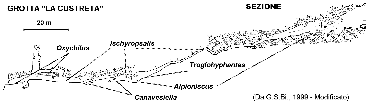
We can number among the more significant species: Alpioniscus cfr. feneriensis![]() , an Araneae Linyphiidae, 2 new species of Ischyropsalis
, an Araneae Linyphiidae, 2 new species of Ischyropsalis![]() actually in study, Chilopoda Lithobiidae and Geophilomorpha, Sphodropsis ghilianii ssp.
actually in study, Chilopoda Lithobiidae and Geophilomorpha, Sphodropsis ghilianii ssp.![]() , Trechus sp. and Oxychilus sp.
, Trechus sp. and Oxychilus sp.![]() .
.
Recently, the author returned to the "Custreta" Cave together to some speleologists belonging to the Biellese Speleological Group, and under the guide or the topographer Renato Sella, we have executed the complete topography of the cave.
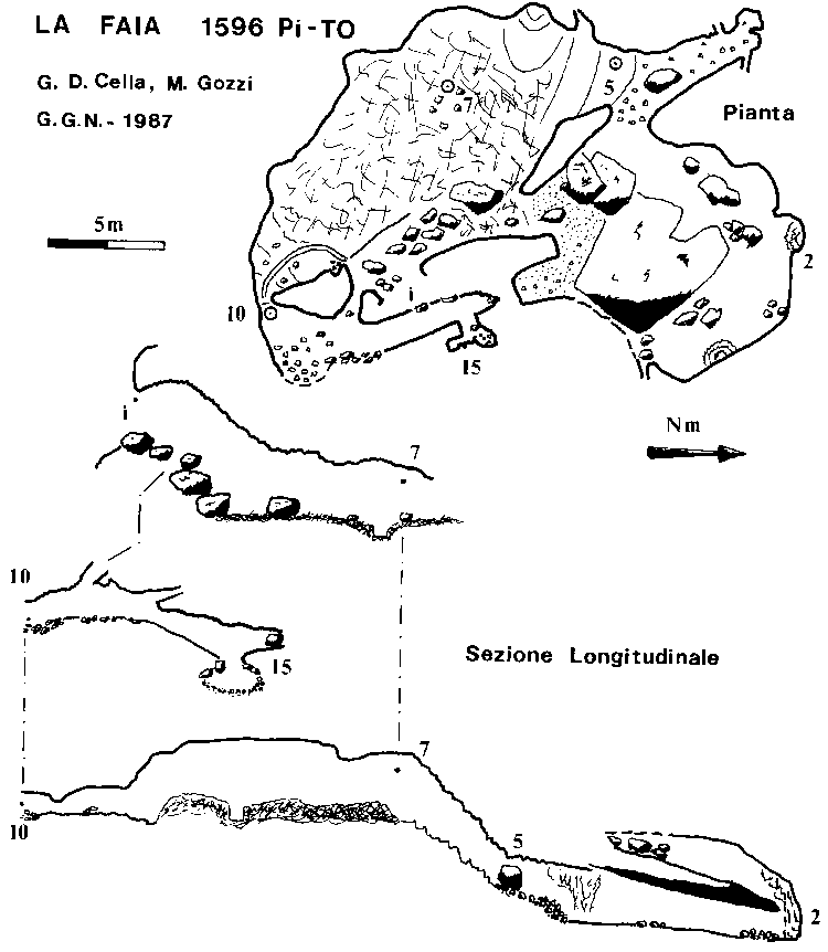
In the same period of the first finding of Canavesiella, the author carried out search also in a little valley![]() near to that of Sparone, where the "Custreta" is situated, and found a similar fauna also in the cave "Boo� d�la Faia"
near to that of Sparone, where the "Custreta" is situated, and found a similar fauna also in the cave "Boo� d�la Faia"![]() (1596 Pi/TO)
(1596 Pi/TO)![]() , above the sanctuary of Prascond�, at about 1800 m above the sea level
, above the sanctuary of Prascond�, at about 1800 m above the sea level![]() .
.
TECHNICAL CARD
|
Commune: |
Ribordone, Talosio |
Valley: |
Ribordone |
|
|
Mons: |
Alpe Rocco |
Map I.G.M.: |
42 III NO Locana |
|
|
Coordinates: |
UTM 32T LR 83353589 |
Quota: |
1780 m a.s.l. |
|
|
Length: |
58 m |
Difference in level: |
-9 m |
|
|
Lithotype: |
Saccharoid limestone |
|||
 |
 |
|
 |
|
BIBLIOGRAPHY |
BIBLIOGRAPHY |
BIBLIOGRAPHY |

|
Return to the page "Caves" |
|
|
|
|


Some embellishments, Javascript, etc. have been modified
from them situated on the site 
"A SBAFO! All for the WEB gratis and in
Italian... "; the author advise you to visit it.


