Gravity measurements over the Chicxulub crater
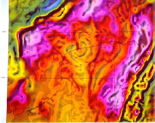
Regional Bouguer gravity anomaly map showing most of the Yucatán peninsula (North is up.). The outline of the peninsula is indicated by a thin dark line. Colour indicates the value of the gravity anomaly - warm colours (purple and red) represent gravity highs, cool colours (green and blue) represent gravity lows. The horizontal gradients of the Bouguer gravity anomaly (the positions of changes in the gravity anomaly values) are shown as grey shading with darker shading corresponding to larger changes. This gravity data set was compiled by the Decade of North American Geology project and consists of survey results gridded at ~6 km spacings. Note that approximately half of the Yucatán block of continental crust (which is outlined by a thick, nearly black gradient feature) is covered by a shallow sea.The Chicxulub crater lies buried, straddling the northwest coastline of the Yucatán peninsula. In this plot three concentric gradient features outline a circular gravity low ~180 km in diameter. The crater's negative anomaly is complicated by regional anomalies, including a low extending to the south and fan-shaped anomalies extending to the north. The crater was named Chicxulub because its center lies near the coastal town of Puerto Chicxulub (Image courtesy Geological Survey of Canada).
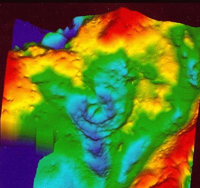
Three-dimensional Bouguer gravity anomaly map over the Chicxulub
crater (North is up.).
Compare with the regional Bouguer map also showing the shaded horizontal gradient.
The crater is represented by the near-circular low central to the figure (with
contained concentric structure).
Notice that regional gravity anomalies interfere with the circular pattern
(fan shape to the north
and double low to the south)
and that a gravity low expressed as a trough occurs to the east side. The
origin of most of the regional anomalies is not yet known, but correlations
to regional magnetic anomalies suggests that many are related to variations
in the basement rocks of the peninsula. Note that this image is not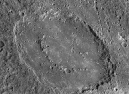 showing the shape of the crater; the negative gravity anomaly of the crater
corresponds to the relatively low densities of the rocks within the crater
(breccias and the melt
sheet) and the Tertiary
sediments filling the crater. The double humped central gravity high corresponds
to the central uplift buried deep within the crater. The Chicxulub
crater has no central topographic feature - the central peak characteristic
of smaller complex craters. Chicxulub is a peak-ring crater
with a poorly known topographic ring occurring at 40 to 45
km radius from the crater's center. A few minutes after the impact
the crater probably looked like a slightly larger version of the 165
km-diameter peak-ring crater Strindberg on Mercury.
Subsequent erosion probably substantially removed the rim of Chicxulub
before it was buried. (Image
courtesy Geological Survey of Canada).
showing the shape of the crater; the negative gravity anomaly of the crater
corresponds to the relatively low densities of the rocks within the crater
(breccias and the melt
sheet) and the Tertiary
sediments filling the crater. The double humped central gravity high corresponds
to the central uplift buried deep within the crater. The Chicxulub
crater has no central topographic feature - the central peak characteristic
of smaller complex craters. Chicxulub is a peak-ring crater
with a poorly known topographic ring occurring at 40 to 45
km radius from the crater's center. A few minutes after the impact
the crater probably looked like a slightly larger version of the 165
km-diameter peak-ring crater Strindberg on Mercury.
Subsequent erosion probably substantially removed the rim of Chicxulub
before it was buried. (Image
courtesy Geological Survey of Canada).
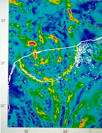
Horizontal gradient map of the Bouguer gravity anomaly over the Chicxulub crater (North is up.). The coastline is shown as a white line. A striking series of concentric features reveals the location of the crater. This image was constructed from gravity measurements taken by Petróleos Méxicanos beginning in 1948 in the course of petroleum exploration augmented by recent work of researchers from the Geological Survey of Canada, Athabasca University, the Universidad Nacional Autónoma de México, and the Universidad Autónoma de Yucatán. These recently acquired data were taken to map out detailed crater structure. All data were gridded at 750 m intervals before the horizontal gradient was computed. Most of the concentric gradient features can be related to inferred structural elements of the buried crater, including the central uplift (note the radial features revealed in the uplift), the collapsed transient cavity edge, faults in the zone of slumping, and the edge of the topographic basin - the now buried crater. White dots represent the locations of water-filled sinkholes (solution collapse features common in the limestone rocks of the region) called cenotes after the Maya word dzonot. A dramatic ring of cenotes is associated with the largest peripheral gravity gradient feature. The cenotes of the ring are typically larger than those found elsewhere on the peninsula. The sinkholes developed when sea level was lower during the Pleistocene glaciation, becoming water-filled when sea level returned to its present level. The ring represents a zone of high permeability where groundwater can flow to the sea creating coastal freshwater springs at the east and west sides of the crater. The origin of the cenote ring remains uncertain, although the link to the underlying buried crater seems clear. The cenotes of the ring are developed in near-surface Tertiary limestones overlying the crater, and are not directly related to the rocks of the crater. Somehow the crater is able to reach up through several hundred metres of sediment, and tens of millions of years of time, to influence groundwater flow. Some form of subsidence controlled by peripheral structure of the crater may have induced fracturing in the much younger rocks that cover the crater. The fracturing could then initiate the groundwater flow that caused the cenotes to form. This subsidence may be continuing today. Note that the crater is able to influence modern erosion of the sediments that bury it. The edges of the crater correspond to a notch in the coastline in the east, and to a sharp bend southwards in the west. Also, the cenote ring corresponds to a topographic low of up to 5 metres along much of its length. (Image courtesy Geological Survey of Canada).
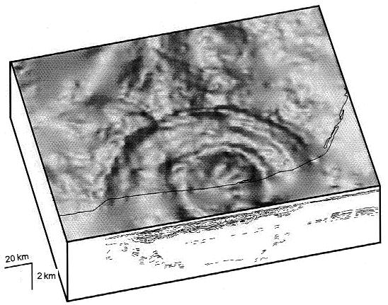
A perspective plot of the ~180 km-diameter Chicxulub crater with a cutaway view showing a cross section of the crater as revealed by seismic reflection data. This view is looking to the south; the Yucatán coastline is shown by a thin dark line. Note the different horizontal and vertical scales such that the cross section has a vertical exaggeration of approximately ten times. The vertical scale is approximate as seismic velocities vary with depth and rock type. The top surface shows the horizontal gradient of the Bouguer gravity anomaly similar to that shown in figure 3. The circular gradient features that correspond to crater structures lose definition near the coast because no gravity field surveying has been done in the coastal shallow water, leading to an approximately 20 km-wide gap in data coverage. The interpretation of seismic reflection data shown on the face of the cutaway is from Camargo and Suarez (1994), and is shown along the line where it was collected by a shipbourne survey. The seismic data reveal much of the crater's structure including the ~1 km-thick Tertiary sediments filling the crater, the crater edges, the peak ring, and the down-dropped blocks in the crater's zone of slumping. Note the contortion of the sediments in the down-dropped blocks. The central zone where no deep structures may be seen corresponds to the crater's collapsed transient cavity. (Image courtesy Geological Survey of Canada).
Tektites produced by the impact
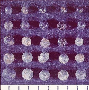
Altered tektites produced by the Chicxulub impact as preserved at the Dogie Creek, Wyoming, Cretaceous-Tertiary boundary locality. The scale bar shows divisions of millimetres. At this locality the ejecta layer from the Chicxulub crater is ~2 cm thick and at some places preserves the shapes of the individual tektites that compose the layer. Originally composed of glass, the tektites have been pseudomorphed (altered and replaced by a secondary mineral while their shape is preserved) by phosphate-bearing minerals (most commonly goyazite) at this site. The tektites are predominantly spheres at this locality; this photograph includes only one egg-shaped individual. (Image courtesy Geological Survey of Canada).
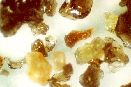
Unaltered tektite glass separated from the Cretaceous-Tertiary ejecta layer as preserved at the Mimbral locality, Tamaulipas state, Mexico. Although the tektite glass has been altered at most localities, a handful of sites preserved in marine sediments have been found where a remnant of the glass is preserved, particularly in carbonate-rich parts of the ejecta layer. The southernmost sites found near Beloc, Haiti contain the greatest abundances of unaltered tektite glass. Mimbral represents the second most prolific locality for tektite glass recovery. This photograph shows the dark brownish green glass which is the most commonly preserved material. The yellow and amber grains represent partially hydrated glass, the hydration is apparently the first step towards alteration/replacement. (Taken by Alan Hildebrand).
Shocked quartz grains produced by the impact
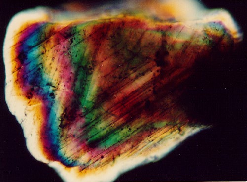
A 0.32 mm shocked quartz grain from intracrater breccia sample Y6 N14 of the Chicxulub crater. The drill hole Yucatán-6 was located ~50 km from the crater's center and penetrated ~500 metres of impact melt and breccias at its base. The melt and breccia units contain clear evidence of production by impact, including mineral grains showing evidence of shock metamorphism. In the mineral quartz the passage of a strong shock wave can cause dislocation of the grain's crystal structure along preferred crystallographic orientations. This quartz grain shows at least 8 sets of planar deformation features when rotated; two strong sets (and part of a third set) of shock lamellae are visible in this orientation. The lamellae are decorated with inclusions. Impact is the only natural process known to produce shock waves of sufficient strength to cause deformation of this type. (Taken in cross-polarized light.).
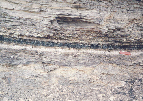
Outcrop of the Cretaceous-Tertiary (K/T) boundary
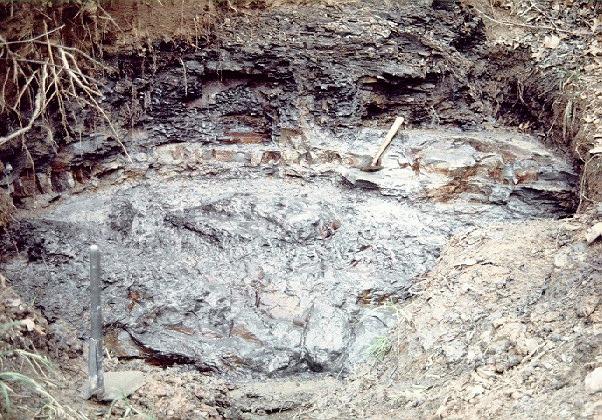
Outcrop of strata crossing the Cretaceous-Tertiary (K/T) boundary at Brazos River, Falls County, Texas; note pick and shovel for scale. The pick rests on a rippled sandstone bed, one of several coarse units found immediately below the paleontological K-T boundary at this locality. The base of the coarse beds is an erosional sequence that is overlain by a sedimentary breccia containing clasts up to one metre in size. The sequence fines upwards to a 0-7 mm dark, calcareous mudstone with associated geochemical anomalies (iridium, gold, rhenium, arsenic, antimony and selenium) that are characteristic of the K/T fireball layer. The sequence of coarse beds is unique in seven million years of Upper Cretaceous and Lower Tertiary stratigraphy exposed along the Brazos River near here and represents a highly unusual geological event. The enclosing strata form a nearly monotonous sequence of mudstones deposited on the middle to outer continental shelf in 100 to 150 metres of water. The coarse boundary sequence apparently represents the deposits produced by a series of giant waves produced by the Chicxulub impact as they rolled across the continental shelf of North America before washing up on the shore. The thin bed with trace-element anomalies apparently represents the fine fraction of the fireball layer that settled out on top of sediments transported and deposited by the giant waves. (Image courtesy Geological Survey of Canada). The coarse boundary sequence would all comprise part of the Chicxulub formation as defined by Hildebrand (1992): "[...] the Chicxulub Formation is defined as the units of rock deposited by the Chicxulub impact including material ejected from the crater, fragments of the projectile if they exist, and secondary deposits produced by the effects of the impact such as seismicity and impact waves." Historically, the significance of this Brazos River deposit is that it is the first locality recognised as having an impact wave deposit. This represented the first step in the process which located the K/T impact to the region between the Americas.
NOTE: The K-T boundary separates the age of the reptiles and the age of the mammals, which was first recognized over one hundred years ago by geologists who realized that there was a dramatic change in the types of fossils deposited on either side of this boundary. This boundary also separates two of the three eras of the Phanerozoic (see time scale at left), which is the time in earth history that began with the origin of complex life and extends to the present. These two eras are called the Mesozoic and Cenozoic. Dinosaurs were prevalent during the Mesozoic Era and extinct during the Cenozoic Era. The last segment of the Mesozoic Era, from 135 to 65 millions of years ago, is called the Cretaceous Period. The first segment of the Cenozoic Era, from 65 million years ago until the present, is called the Tertiary Period. The abbreviation for the boundary between the Cretaceous and Tertiary periods is the K-T boundary, where K is the abbreviation for the German form of the word Cretaceous. This boundary corresponds to one of the greatest mass extinctions in Earth's history. At least 75 percent of the species on our planet, both in the seas and on the continents, were extinguished forever. The most famous of the vanquished are the dinosaurs. However, these giants were only a small fraction of the plants and animals that disappeared. In the oceans, more than 90 percent of the plankton was extinguished, which inevitably led to the collapse of the oceanic food chain. Rocks deposited during the Cretaceous Period and Tertiary Period are separated by a thin clay layer that is visible at several sites around the world. A team of scientists led by Luis Alvarez (a Nobel Prize-winning physicist) and his son Walter (a geologist) discovered that the clay layer contains a strikingly high concentration of iridium, an element that is much more common in meteorites than in Earth's crustal rocks. Like meteorites, asteroids and comets also have relatively large abundances of iridium. Consequently, they proposed that an impacting asteroid or comet hit the Earth, generating the iridium anomaly, and causing the mass extinction event (?). The discovery of high iridium concentrations in the clay layer at several places around the world suggested the impact was a large one.
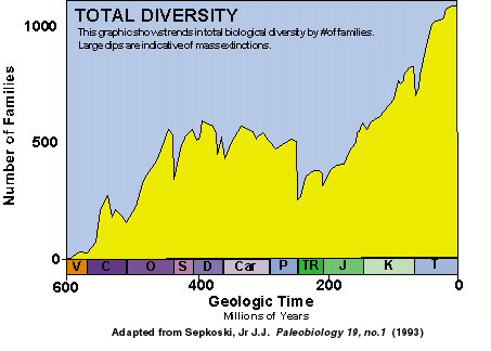
This graphic shows biological diversity throughout geologic time. The dips indicate mass extinction events.
These findings led to an extensive search for a large impact crater that is 65 million years old. Seven researchers finally located the impact site on Mexico's Yucatan Peninsula. It is a huge buried impact crater that is called Chicxulub, a Maya word that roughly translates as "tail of the devil." The crater, now buried beneath a kilometer-thick sequence of sediments, has been imaged using geophysical techniques that allow us to visualize underground structures. It appears to have a diameter of 145 to 180 km, which makes it one of the largest confirmed impact structures on Earth. Only Sudbury in Canada and the Vredefort structure in South Africa could potentially be larger.
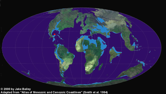
A paleogeographic reconstruction of the continents 65 Ma showing the impact location in red and modern continents then submerged in light blue.
The asteroid or comet that produced the Chicxulub crater was roughly 10 km in diameter. When an object that size hits Earth's surface, it causes a tremendous shock wave while transferring energy and momentum to the ground. The impact was similar to a large explosion, although the energy of the Chicxulub impact dwarfs anything modern civilization has experienced. The energy of the impact was comparable to 100 million megatons of TNT, 6 million times more energetic than the 1980 Mount St. Helens volcanic eruption. The impact ejected rock from several kilometers beneath the surface of the Earth and carved out a bowl-shaped crater nearly 100 km in diameter. In addition, the shock of the impact produced magnitude-10 earthquakes, which were greater than the magnitude of any we have ever measured in modern times.
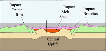
Chicxulub Structure
The initial bowl-shaped crater was very unstable, and its walls quickly collapsed along a series of faults that enlarged the final diameter to between 145 and 180 km. At the same time, the rock that had been compressed beneath the crater by the impact rebounded, producing a peak-ring structure in the crater's center. These dramatic changes, which rapidly transported huge volumes of rock over distances of tens of kilometers, occurred within only a few minutes.

Peak Ring Crater Animation
Because the impact site was in a shallow sea, water rushed in to fill the circular depression. Kilometer high waterfalls tumbled over the rim of the crater and roared furiously across the floor of the crater. Because seawater filled and covered the crater, sediment on the bottom of the sea soon buried the impact scar. The crater is no longer visible today, even when standing directly over it. In more recent times, the impact crater has affected the circulation of groundwater on the Yucatan Peninsula. This groundwater, has in some areas, dissolved the limestone in the Yucatan peninsula. Below ground, this has produced caves. At the surface, this has produced cenotes which are groundwater springs. The explosion that produced the Chicxulub crater excavated a huge amount of material, which was then ejected upwards. Most of the debris was deposited as a blanket of material that covered North America and possible South America. Near the impact crater the debris is tens to hundreds of meters thick, while as far away as Colorado (over 2000 km distance), the debris is still a centimeter thick (see photograph below). Additional material was lofted in an expanding, vapor-rich plume that included gas from the vaporized asteroid or comet. This plume rose far above the Earth's atmosphere, enveloping it, and eventually depositing a thin layer of debris around the entire world.
Photograph of the K/T boundary sequence at Raton Basin in Colorado. The light gray unit in the middle of the photograph (marked with the red knife) is composed of two layers that mark the K-T boundary. A coal deposited in the Tertiary Period, after dinosaurs disappeared, is deposited on top of the K-T boundary layers.
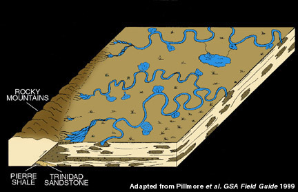
Diagram of the Raton Basin as it appeared before the impact event. The mudstone and siltstone at the bottom of the above Raton Basin photograph were deposited in an environment such as this. Adapted from Pillmore et al. in GSA Field Guide 1999.
The LUNAR CATACLYSM HYPOTHESIS
Was the origin of life connected to the lunar cataclysm ?...
Immagine a 360° della superficie lunare. Apollo 14. Usa il mouse per navigare nell'immagine.
The most famous impact event that affected Earth is perhaps the Chicxulub impact event, "which has been linked" to the extinction of the dinosaurs 65 million years ago (?). It is, however, only one of many impact events that have affected our planet and not even one of the largest. The record of these processes is very poor on Earth, because our planet has a lot of geologic processes that destroy or mask evidence of impact events. Mountain building processes crumple impact craters, plate subduction consumes impact craters, erosion dissects impact craters, and lava flows and sediments often bury any remaining impact craters. While scientists continue to discover a handful of impact craters each year, the number of known craters is quite small (currently ~160; see Map for a current listing of impact craters). A much better record of the impact cratering history of the Earth is preserved on our neighboring Moon. Because water does not flow across its surface, lava no longer erupts from its volcanoes, and plate tectonics has never occured there, the record of bombardment in the Earth-Moon system is far better preserved. Over 300,000 impact craters the size of Barringer Crater (or Meteor Crater; ~1km in diameter) in Northern Arizona and larger exist on the Moon. They have been created as asteroids and comets pelted its surface, at the same time similar object pelted the Earth. However, because of the Earth's larger size, it would have suffered about 10 times more impact events, or over 3 million impact craters greater than 1 km in diameter ! These impact craters have been produced on the Earth and Moon over their 4.5 to 4.6 billion year history. Studies of the impact cratering histories of the Earth-Moon system and observations of asteroids and comets in our solar sytem indicate that impact events continue to occur on both the Earth and Moon and that they occured more frequently earlier in Earth's history. But an additional twist of this story began to emerge when scientists began studying rocks collected on the Moon by Apollo astronauts. Analyses of lunar samples collected by Apollo astronauts revealed a surprising feature: the crust of the Moon seems to have been severely heated ~3.9 billion years ago, metamorphosing the rocks in it. Scientists suggested this metamorphic event may have been created by a large number of asteroid and/or cometary collisions in a brief pulse of time, <200 million years, in what was called the lunar cataclysm. If a lunar cataclysm really occurred, then lots of impact melted rocks with that same age should also exist. And, indeed, additional analyses of impact melts collected by Apollo astronauts revealed a range of impact ages, but, significantly, none older than 3.85Ga. This also seemed to imply a lunar cataclysm ~3.9 Ga, which completely destroyed or metamorphosed impact melts produced by older impact events.
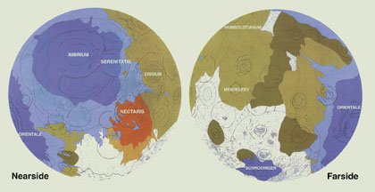
Maps showing regions of the Moon that were resurfaced during Nectarian Period (brown) and Imbrian Period (blue), and outlines of larger basins. Also shown are pre-Nectarian units (darkest brown) and areas of unclear stratigraphic relationships (gray).
However, the interpretation of these data were controversial, because all of the Apollo landing sights were restricted to the nearside equatorial region of the Moon. This restriction was a mission limitation because it was necessary to maintain communication with Earth. The result, unfortunately, was a potentially biased set of samples. Critics of the luanr cataclysm hypothesis suggested the Apollo samples are dominated by the effects of the large impact basins (Nectaris, Cresium, Serenitatis, and Imbrium) in the nearside equatorial region of the Moon and do not reflect a global impact record. More recently, a new set of samples was discovered that can help test the hypothesis of a lunar cataclysm. Begining in 1981, scientists began finding meteorites that looked very similar to the rocks collected by Apollo astronauts. It was soon realized that these meteorites came from the Moon and were delivered to the Earth by recent impact events on the lunar surface. Since impact events occur randomly on the surface of the Moon, the collection of lunar meteorites provided a set of samples from a much larger region of the lunar surface than the Apollo collection. They were a perfect set of samples to test the lunar cataclysm hypothesis. Among the lunar meteorite collection was a set of rocks called regolith breccias. These are rocks composed of the broken fragments of lots of other, older rocks. Some of these fragments are samples of impact melts that occured farther back in the moon's history. To test the lunar cataclysm hypothesis, one could extract these fragments and determine when they had formed. If they also failed to record impact events prior to 3.9 Ga, like the Apollo samples, then this would seem to confirm the lunar cataclysm hypothesis.
Examples of the Largest Craters Produced by the Cataclysm on the Moon
|
|
Diameter (km) | Age (Billion Years) |
| Orientale | 930 | ~3.85 |
| Schrödinger | 320 | |
| Imbrium | 1200 | 3.85 +/- .01 |
| Bailly | 300 | |
| Sikorsky-Rittenhouse | 310 | |
| Hertzprung | 570 | 3.89 +/- .009 |
| Serenitatis | 740 | 3.895 +/- .017 |
| Crisium | 1060 | |
| Humorum | 820 | |
| Humboldtianum | 700 | |
| Medeleev | 330 | |
| Korolev | 440 | |
| Moscovienese | 445 | |
| Mendel-Rydberg | 630 | |
| Nectaris | 860 | 3.89 - 3.91 |
In a University of Arizona study released in 2000, the ages of impact melts in 4 lunar meteorites were reported. The collection of impact melt samples had a range of ages, meaning they had been produced in impact events that occurred from 3.9 to 2.7 billion years ago on the Moon. Significantly, none of the ages were older than ~3.9 billion years ago. In the case of the Moon, this event appears to have nearly resurfaced the entire planet.
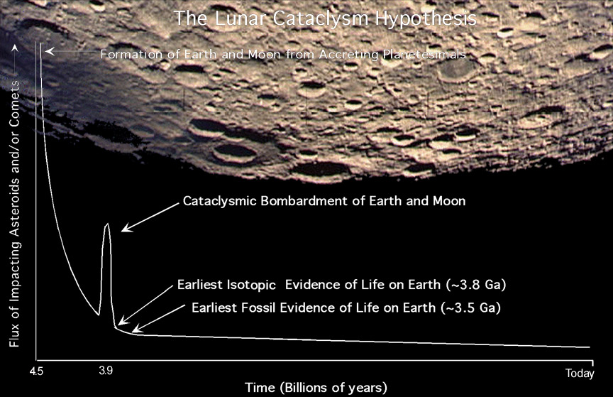
Observations of impact craters on the Moon indicate that >1,700 impact craters with diameters >20 km were produced during the cataclysm. This implies that >17,000 impact craters with diameters >20km were produced on the Earth during this same period of time, which lasted from 20 to 200 million years. Each of these impact events is large enough to have produced global effects and some of the largest would have produced impact craters with diameters that exceeded 1,000 km. That is, impact craters the size of continents were being produced on the Earth. Scientists are now wondering if this cataclysmic bombardment may have affected life on Earth or been involved in life's origins. The earliest isotopic evidence of life we have is from rocks ~3.8 billion years old, immediately after the cataclysm.
This is a short routine to evaluate the scaling equations to determine the diameter of a crater given details on the nature of the projectile, conditions of impact, and state of the target. The transient crater diameter is evaluated by three independent methods, yield scaling, pi-scaling and Gault's semi-empirical relations supplemented by rules on how crater size depends on gravity and angle of impact.
program crater
c
c Short program to evaluate the scaling equations to determine
c the diameter of a transient crater given details on the nature
c of the projectile, conditions of impact, and state of the
c target. The diameter is evaluated by three independent methods,
c yield scaling, pi-scaling and Gault's semi-empirical relations
c supplemented by rules on how crater size depends on gravity and
c angle of impact.
c
c Updated Nov. 1997 to compute projectile size from a given
c transient crater diameter. Projectile and crater diameter
c computation functions merged into a single program April 1998.
c See Melosh, Impact Cratering, chapter 7 for more details
c
c Updated Oct. 1999 to take final crater diameters as well as
c transient crater diameters into account.
c
c
implicit none
real*4 Cd(3),beta(3),Ct,Dt,Dstd,L,rhoproj,v,theta,rhotarget,g,W
real*4 pi,third,pitwo,pifac,gearth,gmoon,m,dscale,anglefac,densfac
real*4 rhomoon,Dstarmoon,Dstar,Dsimple,Dpr,Dprmoon,Dfinal
real*4 Dpiscale,Dyield,Dgault,gsmall,Tform
real*4 Lpiscale,Lyield,Lgault
character ans,cratertype*14
integer targtype,comptype
pi=3.14159265
third=1./3.
c
c constants for the Schmidt-Holsapple pi scaling and
c gravity conversion factors
c
data Cd/1.88,1.54 ,1.6 /
data beta/0.22,0.165,0.22/
data gearth,gmoon/9.8,1.67/
data rhomoon,Dstarmoon,Dprmoon/2700.,1.8e4,1.4e5/
c
c***********************************************************************
c
c get input conditions from the user's keyboard
c
c***********************************************************************
10 continue
write(*,999)
read(*,*) comptype
if((comptype.ne.1).and.(comptype.ne.2)) then
write(*,1010)
goto 10
endif
if(comptype.eq.2) then
write(*,1400)
read(*,*) Dt
if(Dt.eq.0.0) then
write(*,1500)
read(*,*) Dfinal
endif
endif
write(*,1000)
read(*,*) rhoproj
if(comptype.eq.1) then
write(*,2000)
read(*,*) L
endif
write(*,3000)
read(*,*) v
write(*,4000)
read(*,*) theta
write(*,5000)
read(*,*) rhotarget
write(*,6000)
read(*,*) g
20 write(*,7000)
read(*,*) targtype
if((targtype.lt.1).or.(targtype.gt.3)) then
write(*,7010)
goto 20
endif
c
c convert units to SI and compute some auxiliary quantites
c
v=1000.*v !km/sec to m/sec
Dt=1000.*Dt !km to m
Dfinal=1000.*Dfinal !km to m
theta=theta*(pi/180.) !degrees to radians
anglefac=(sin(theta))**third !impact angle factor
densfac=(rhoproj**0.16667)/sqrt(rhotarget)
pifac=(1.61*g)/v**2 !inverse froude length factor
Ct=0.80 !coefficient for formation time
if(targtype.eq.1) Ct=1.3
Dstar=(gmoon*rhomoon*Dstarmoon)/(g*rhotarget) !transition crater
diameter
Dpr =(gmoon*rhomoon*Dprmoon )/(g*rhotarget) !peak-ring crater
diameter
c
c***********************************************************************
c
c computation for specified projectile diameter
c
c***********************************************************************
if(comptype.eq.1) then
m=(pi/6.)*rhoproj*L**3 !projectile mass
W=0.5*m*v**2 !projectile kinetic energy
pitwo=pifac*L !inverse froude number
dscale=(m/rhotarget)**third !scale for crater diameter
c
c Pi Scaling (Schmidt and Holsapple 1987)
c
Dpiscale=dscale*Cd(targtype)*pitwo**(-beta(targtype))
Dpiscale=Dpiscale*anglefac
c
c Yield Scaling (Nordyke 1962) with small correction for depth
c of projectile penetration
c
Dyield=0.0133*W**(1/3.4)+1.51*sqrt(rhoproj/rhotarget)*L
Dyield=Dyield*anglefac*(gearth/g)**0.165
c
c Gault (1974) Semi-Empirical scaling
c
gsmall=0.25*densfac*(W**0.29)*anglefac
if(targtype.eq.3) gsmall=0.015*densfac*(W**0.37)*anglefac**2
if(gsmall.lt.100.) then
Dgault=gsmall
else
Dgault=0.27*densfac*(W**0.28)*anglefac
endif
Dgault=Dgault*(gmoon/g)**0.165
c
c Compute crater formation time from Schmidt and Housen
c
Tform=(Ct*L/v)*pitwo**(-0.61)
c
c Compute final crater type and diameter from pi-scaled transient dia.
c
Dsimple=1.56*Dpiscale
if (Dsimple.lt.Dstar) then
Dfinal=Dsimple
cratertype='Simple'
else
Dfinal=(Dsimple**1.18)/(Dstar**0.18)
cratertype='Complex'
endif
if((Dsimple.lt.Dstar*1.4).and.(Dsimple.gt.Dstar*0.71))
& cratertype='Simple/Complex'
if(Dfinal.gt.Dpr) cratertype='Peak-ring'
c
c Print out results
c
write(*,8000) Dyield,Dpiscale,Dgault,Tform
write(*,8100) Dfinal/1000.,cratertype
c
c***********************************************************************
c
c computation for specified crater diameter
c
c***********************************************************************
elseif(comptype.eq.2) then
c
c convert input crater rim-to-rim diameter to transient crater dia.
c
if(Dt.eq.0.) then
if(Dfinal.lt.Dstar) then
Dt=0.64*Dfinal
else
Dt=0.64*(Dfinal*Dstar**0.18)**0.8475
endif
endif
dscale=((6.*rhotarget)/(pi*rhoproj))**third
c
c Pi Scaling (Schmidt and Holsapple 1987)
c
Dstd=Dt/anglefac
Lpiscale=(Dstd*dscale*pifac**beta(targtype))/Cd(targtype)
Lpiscale=Lpiscale**(1./(1.-beta(targtype)))
c
c Yield Scaling (Nordyke 1962) without correction for projectile
c penetration depth.
c
Dstd=(Dt*(g/gearth)**0.165)/anglefac
W=(Dstd/0.0133)**3.4
Lyield=((12.*W)/(pi*rhoproj*v**2))**third
c
c Gault (1974) Semi-Empirical scaling
c
Dstd=Dt*(g/gmoon)**0.165
if((Dstd.le.10.).and.(targtype.eq.3)) then
W=((Dstd/0.015)/(densfac*anglefac**2))**2.70
elseif(Dstd.lt.300.) then
W=((Dstd/0.25)/(densfac*anglefac))**3.45
else
W=((Dstd/0.27)/(densfac*anglefac))**3.57
endif
Lgault=((12.*W)/(pi*rhoproj*v**2))**third
c
c Compute crater formation time for Pi-scaled diameter
c
Tform=(Ct*Lpiscale/v)*(pifac*Lpiscale)**(-0.61)
c
c Print out results
c
write(*,8500) Lyield,Lpiscale,Lgault,Tform
else
write(*,9500) comptype !user should never get here
endif
c
c***********************************************************************
c
c Check to see if user wants to quit
c
c***********************************************************************
write(*,9000)
read(*,*) ans
if((ans.eq.'Y').or.(ans.eq.'y')) goto 10
stop
c
999 format(/
&' *** IMPACT SIZE ***'//
&'This is a program to estimate the size of a gravity-'/
&'dominated impact crater or the projectile that made it.'/
&'Three different estimates are presented, but the '/
&'pi-scaling method is currently considered the best!'//
&' enter the type of computation desired (1 or 2):'/
&' type 1, crater size'/
&' type 2, projectile size....................... ',$)
1010 format(/
&' entry error! computation type must be 1 or 2. Try again!')
1400 format(/
&'Crater descriptor:'//
&' enter the transient crater diameter in km'/
&' (if the final, not the transient crater diameter'/
&' is known, enter zero (0.0) here)................. ',$)
1500 format(/
&' enter the final crater diameter in km............. ',$)
1000 format(/
&'Projectile descriptors:'//
&' enter the projectile density in kg/m^3............ ',$)
2000 format(
&' enter the projectile diameter in m................ ',$)
3000 format(/
&'Impact conditions:'//
&' enter the impact velocity in km/sec............... ',$)
4000 format(
&' enter the impact angle in degrees................. ',$)
5000 format(/
&'Target descriptors:'//
&' enter the target density in kg/m^3................ ',$)
6000 format(
&' enter the acceleration of gravity in m/sec^2...... ',$)
7000 format(
&' enter the target type, (1-3):'/
&' type 1 = liquid water'/
&' type 2 = loose sand '/
&' type 3 = competent rock or saturated soil....... ',$)
7010 format(//'target type must be 1, 2 or 3. try again!'//)
8000 format(//'Three scaling laws yield the following *transient*',
&' crater diameters:'/
&' (note that diameters are measured at the pre-impact surface.'/
&' Rim-to-rim diameters are about 1.25X larger!)'//,
&' Yield Scaling Dyield = ',1pe10.2,' m'/
&' Pi Scaling (Preferred method!) Dpiscale = ',1pe10.2,' m'/
&' Gault Scaling Dgault = ',1pe10.2,' m'//
&' Crater Formation Time Tform = ',1pe10.2,' sec'
& //)
8100 format(
&'Using the Pi-scaled transient crater, the *final* crater has'/
&'rim-to-rim diameter=',1pe10.2,' km, and is of type: ',a14//)
8500 format(//'Three scaling laws yield the following projectile',
&' diameters:'/
&' (note that diameters assume a spherical projectile)'//
&' Yield Scaling Lyield = ',1pe10.2,' m'/
&' Pi Scaling (Preferred method!) Lpiscale = ',1pe10.2,' m'/
&' Gault Scaling Lgault = ',1pe10.2,' m'//
&' Crater Formation Time Tform = ',1pe10.2,' sec'
& //)
9000 format('Do you want to make another calculation (y/n)?......',$)
9500 format('unrecognized computation type = ',i5,
&' (should be either 1 or 2)')
end
Criteri decisionali per stabilire una GRANDE ESTINZIONE
Nella storia del nostro pianeta si sono verificate moltissime estinzioni, piccole o grandi che siano hanno comportato la scomparsa di specie o di gruppi di specie. Un paleontologo americano, G.Simpson, ha calcolato che dall'origine della vita ad oggi si sono estinte il 97% delle specie esistite. C'è però chi sostiene che le specie non si estinguano, ma evolvano in altre specie per selezione naturale. In questo caso quando una specie si trasforma (evolve) in un'altra si dice che c'è stata una pseudo-estinzione. Secondo alcuni le estinzioni possono essere graduali, richiedendo milioni di anni affinchè una specie scompaia e la loro apparente rapidità sarebbe dovuta alla incompleta documentazione fossile. Il soccombere di una specie sarebbe determinato dai caratteri da essa posseduti che si sono modellati in tempi darwiniani per adattamento all'ambiente circostante. Un'estinzione definita catastrofica invece avviene in modo improvviso ed i caratteri, favorevoli o meno evolutosi nella specie in tempi normali, sarebbero del tutto ininfluenti per decidere della sua sopravvivenza. Le regole sono quindi diverse e affidate alla casualità.
A tutt'oggi sono state individuate cinque grandi estinzioni più alcune minori:
1°-450 milioni di anni fa, fine Ordoviciano, una glaciazione prolungata dovuta al passaggio del continente Gondwana nei pressi del Polo sud causò l'abbassamento del livello del mare e la riduzione degli habitat marini. In quest'epoca la vita ancora non si era diffusa sulla terraferma. La percentuale stimata di specie estinte è dell'85%;
2°-365 milioni di anni fa, fine Devoniano, per glaciazione o impatti asteroidali scompaiono circa il 70% delle specie marine e degli invertebrati terrestri;
3°-250 milioni di anni fa, fine Permiano, la più grande estinzione di tutti i tempi. La percentuale stimata di specie coinvolte è del 90-95%, meno del 5% delle specie marine riuscì a sopravvivere mettendo a dura prova la presenza della vita sulla Terra. Secondo alcune ipotesi questa fu un'estinzione che avvenne in tempi rapidissimi, meno di 100.000 anni, e l'analisi dei campioni di roccia fa supporre che ci sia stato qualche fenomeno esterno (come la caduta di un asteroide) che abbia sviluppato una enorme quantità di energia. È stato anche trovato un cratere da impatto risalente al Permiano, ma sia prima che dopo questa grande estinzione se ne sono verificate due minori per cui l'argomento è ancora discusso. L'ipotesi alternativa è che invece l'estinzione sia stata causata da un intenso vulcanismo verificatosi proprio in quel periodo come dimostrano enormi depositi basaltici derivati dall'accumulo di lava. Gli effetti sul clima sono gli stessi in entrambi i casi. Altre ipotesi minori vedono come causa di estinzione della vita marina l'anossia, cioè la mancanza di ossigeno causata da motivi sconosciuti, oppure per concentrazione troppo elevata di anidride carbonica. Evidenze di anossia anche questa volta sono state rilevate dall'analisi delle roccie marine risalenti al Permiano.
4°-205 milioni di anni fa, fine Triassico, la percentuale di specie coinvolte è del 75% con prevalenza di organismi marini;
5°-65 milioni di anni fa, fine Creataceo, l'estinzione più famosa quella che determinò la scomparsa dei dinosauri. La percentuale stimata di specie coinvolte è dell'80%.
L'ipotesi inizialmente più diffusa come causa di questa estinzione fu l'esplosione di una supernova molto vicina alla Terra. Successivamente si scoprì negli strati geologici nei pressi di Gubbio una insolita concentrazione di iridio, elemento raro sulla Terra ma comune nelle meteoriti (e nelle eruzioni vulcaniche) e si fece strada un'altra ipotesi, quella di un evento extraterrestre. Cominciò allora la caccia al cratere da impatto che si concluse diversi anni dopo nello Yucatan dove un'enorme struttura circolare sotterranea che era stata scambiata per un vulcano venne identificata, grazie a rilevazioni dal satellite, come cratere originato dall'impatto di una meteora o di una cometa del diametro di circa 10 chilometri e che secondo le stime liberò un'energia pari a 10.000 volte quella che si sarebbe potuta liberare da tutto l'arsenale nucleare mondiale ai tempi della seconda guerra mondiale. Questa ipotesi è oggi quella che trova i maggiori consensi, ma non è universalmente accettata.
NOTA: (alcune mie "profonde" riflessioni...) La storia geologica del nostro pianeta è costellata di estinzioni, più o meno importanti. Quella avvenuta alla fine del Mesozoico è soltanto la più nota, probabilmente a causa della scomparsa di un gruppo di organismi ben noto al pubblico, i dinosauri. In realtà insieme ai grandi rettili scomparvero, in quell'occasione, molti altri organismi, quali cefalopodi (ammoniti, belemniti), molluschi (rudiste), protisti (rotalipore, globotruncane)...organismi che ben pochi conoscono. Se per un momento tralasciamo l'estinzione di fine Mesozoico, scopriamo che vi sono state diverse importanti estinzioni, negli ultimi 500 milioni di anni: in particolare sono note le estinzioni della fine dell'Ordoviciano e della fine del Permiano; in realtà bisognerebbe parlare anche delle estinzioni della fine del Devoniano, di quella avvenuta tra il Triassico ed il Giurassico, ecc. Tutte queste estinzioni "di massa" interessarono una cospicua percentuale di tutte le forme di vita esistenti, e certamente episodi come questi, indipendentemente dalle cause - ancora da determinare - hanno messo a dure prova la resistenza e la stessa sopravvivenza della vita sul nostro pianeta. Tuttavia, alcuni milioni di anni sono sufficienti affinchè la diversificazione biologica, la speciazione e i fenomeni evolutivi portino ad una nuova rinnovata espansione delle forme di vita sulla Terra. Alcuni autori hanno avanzato l'ipotesi che a partire dal Permiano (fine Paleozoico) si sia verificata un'estinzione ogni 26 milioni di anni (la causa sarebbe da ricercarsi in un'ipotetica compagna oscura del Sole, la stella Nemesis, che ogni 26 milioni di anni passerebbe attraverso la nube di Oort, serbatoio di comete ed asteroidi, provocando un bombardamento a tappeto in tutto il sistema solare). Altri attribuiscono l'estinzione di fine Mesozoico ad un disastroso vulcanismo globale. Riferimenti sulle due teorie, quella dell'impatto meteoritico e quella del vulcanismo globale, possono esere trovate nella bibliografia (Estinzione e sopravvivenza: letture dalle Scienze). Altri autori, infine, affermano sia inutile ricercare una causa specifica per un'estinzione. L'estinzione di massa avvenuta alla fine del Paleozoico (250-220 milioni di anni fa) è stata probabilmente la più estesa e grave: si stima che oltre il 90 per cento di tutte le forme di vita del nostro pianeta scomparvero nel giro di pochi milioni di anni. Essa è così lontana nel tempo che rimangono poche tracce studiabili, in ogni caso la vita attuale non mostra alcuna traccia di quel remoto "incidente". Per quel che riguarda l'ultima grande estinzione, quella di fine Cretaceo (quella in cui scomparvero "anche" i dinosauri), sono passati 65 milioni di anni da allora: la scomparsa progressiva - probabilmente durò svariati milioni di anni - dei grandi rettili liberò una grande quantità di nicchie ecologiche, subito conquistate dai piccoli mammiferi, organismi a sangue caldo presenti già dal Triassico ma, durante la dominazione dei rettili, relegati ad un ruolo secondario. Cosa sarebbe accaduto se i rettili non si fossero estinti, decine di milioni di anni fa ? Avrebbero potuto evolvere verso forme intelligenti ? Avrebbero potuto sviluppare una civiltà, una tecnologia ? Nessuno conosce sufficientemente i meccanismi evolutivi da poter immaginare cosa avrebbero potuto fare i rettili se avessero potuto dominare sulla terra per altre decine di milioni di anni. Un'estinzione non comporta necessariamente la scomparsa della vita; in genere si tratta della scomparsa di un gruppo limitato di organismi, a favore di un gruppo di animali (o vegetali) più agguerrito e resistente, che ne prende il posto. Una delle variabili più importanti in questo avvicendamento di famiglie, generi e specie biologiche è l'adattamento alle modificazioni ambientali. Nel corso dell'estinzione, o, per usare un termine più appropriato, della crisi biologica della fine del Paleozoico, forse la più importante della storia geologica del nostro pianeta, scomparvero i nautiloidi, molluschi cefalopodi oggi rappresentati da pochissime specie (esempio, l'argonauta, o il nautilus), ed il loro posto fu preso dai cefalopodi ammoniti. Le ammoniti costituiscono un gruppo di fossili-guida importantissimo, per cui le conosciamo molto bene. A loro volta le ammoniti si estingueranno alla fine del Cretaceo, insieme ai dinosauri e ad altri. Il loro posto, nei mari del nostro pianeta, fu preso dai teleostei, i pesci ossei. La famiglia degli ominidi, alla quale apparteniamo noi (e solo noi) non ha mai avuto un contatto diretto coi dinosauri. Gli ominidi comparvero solo molte decine di milioni di anni dopo la scomparsa dell'ultimo dinosauro. Antenati umanoidi compresi, siamo comparsi sulla scena della vita terrestre appena quattro milioni di anni fa. I dinosauri dominarono la terra per oltre centocinquanta milioni di anni. Tutto sommato, siamo un genere animale piuttosto giovane. Non rischiamo una crisi biologica naturale ma ora siamo noi a provocare l'estinzione di centinaia di specie ogni anno, a causa degli sconvolgimenti ambientali provocati dalle nostre attività. Le teorie avanzate dagli studiosi per cercare di spiegare le estinzioni di massa sono tante e tanto si è scritto. Vorrei soltanto segnalare l'insolita spiegazione fornita da Kock nel 1967 per spiegare la scomparsa di così tanti organismi alla fine del Cretaceo. Secondo questo autore l'estinzione potrebbe essere stata provocata dalla presenza del selenio, un elemento proveniente da ceneri e rocce vulcaniche, particolarmente abbondante nei sedimenti del Cretaceo superiore. Questo elemento, assorbito dai vegetali, potrebbe aver provocato l'avvelenamento e quindi la scomparsa degli erbivori, e, conseguentemente, dei carnivori. La spiegazione più bizzarra: quella secondo la quale a provocare l'estinzione dei grandi rettili sarebbe stata la sistematica predazione delle loro uova da parte dei primi, piccoli mammiferi. Vai a LINK correlato.
Bibliografia...
AA.VV. (1988) - La testimonianza
dei fossili. Le Scienze Quaderni n.42.
AA.VV. (1992) - Estinzione e sopravvivenza. Le Scienze Quaderni n.68.
Allasinaz A. (1985) - Paleontologia Generale. ECIG. Genova.
Carta M. (1999) - Introduzione alla Paleontologia. Ed. Windcloak. Udine.
Cock N.C. (1986) - Disappearance of the dinosaurs. Journ. of Paleontology
n.44.
Fortey R. (1997) - Età: quattro miliardi di anni. Longanesi &
C.
Gayrard-Valy Y. (1987) - I fossili: orme di mondi scomparsi. Electa/Gallimard.
Halstead L.B. (1982) - Alla ricerca del Passato. Ist. geografico de
Agostini.
Malaroda R. (1975) - Paleontologia generale. Ed. CEDAM, Padova.
Padoa E. (1978) - Storia della vita sulla Terra. Feltrinelli.
Rossi Ronchetti R. (1981) - Lezioni di Paleontologia generale. UNICOPLI,
MI
Sarà M. (1994) - L'evoluzione dei viventi. Fenice 2000. Milano
Simpson G.G. (1987) - I fossili e la storia della vita. Zanichelli.
Stanley S.M. (1982) - L'evoluzione dell'evoluzione. Mondadori.
Thenius E. (1975) - Testimonianze fossili. Boringhieri.
Van Andel T.H. (1985) - Storia della Terra. Mondadori.


