|
Biospeleology of the Piemonte |
 |
Systematic Photographic |
|
Biospeleology of the Piemonte |
|
Systematic Photographic |
 |
|
|
|
 |
 |
 |
|
 |
 |
|
|
|
|
|
RASSEGNA SPELEOLOGICA ITALIANA
MEMORIA IX
GRUPPO SPELEOLOGICO PIEMONTESE
C.A.I. - U.G.E.T. - TORINO - 1970
SPELEOLOGIA DEL PIEMONTE
PARTE II -
The MONREGALESE2) The Tanaro Valley
a) The Armetta Mons zone and the other caves on the right side of the Tanaro River
32
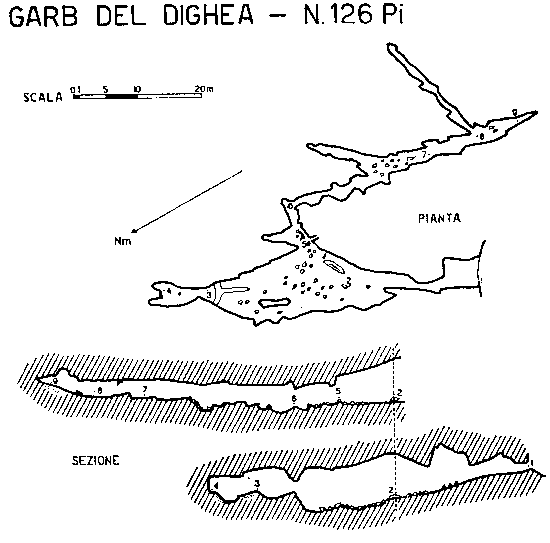
No. 126 Pi (CN) - GARB DEL DIGHEA
Commune of Ormea, Village Alpisella, Resort Colla Bassa.
Itinerary
From Ormea follow the carriage way toward Alpisella and from here the road of Caprauna as far as the north-western slopes of the Guardia Mons, where begin a muletrack that leads to the Colla Bassa. The cave opens at about 200 metres from the Colla and can be reached following the grassy slope towards the Armetta Mons: the entrance is visible at the basis of a rocky step.
IGM Map 31 II NE (Ormea); long. 4�31'09"; lat. 44�07'40";
UTM Coordinates: 1480 8601; distance 1030 m far in the direction south 26� west from the Armetta Mons.
Altitude: about 1590 m over the sea level.
DESCRIPTION
The entrance is shallow (1 X 4 m) and exposed to south, open in Triassic limestone, introduce through a bottleneck to an ascending hall (10 X 25 m) with landslides and rocky walls, isolated by the fusion of cavities open in slits and in parallel diaclasis (evident in the vault); by the sides there are short tunnels and inchways. The great hall ends after a short slope in a closed room with little niches and water pool in the thaw season.
About in the middle of the hall, on the right side, there is a split through which enters in a little gallery with lateral niches and ravines, and walls with calcareous shields. Then the corridor turns and opens in a space with breakdowns and ends in a fissure stop up by earth; to the left it shows a narrow branch with a muddy floor. Totally the cave is 143 m long and has a difference in level of 6 m down from the entrance.
The temperature was 7,2�C in the inner part (June); here there is a lot of humidity and dropping water. A faible rocky covering separates the cave from the overhanging karstic tableland.
TOPOGRAPHY
Performed by Dematteis in 1955 (see. pag. 159).
159
|
|
|
 |
|


Some embellishments, Javascript, etc. have been modified
from them situated on the site 
"A SBAFO! All for the WEB gratis and in
Italian... "; the author advise you to visit it.