NAUTICAL PAPER
Guides of NAUTICAL PAPER
NAUTICAL PAPER
Hydrographical institute
The ECDIS is also a concrete example of coordination to normative level and standardization between various international organizations which the IMO (International Maritime Organization, organism of the UN that coordinates relative the normative activities and of standardization to international marine navigation), the IHO (International Hydrographic Organization, organization that coordinates the procedures and the standards for the production and spread of international nautical cartography) and the IEC (International Electrotechnical Commission).
Even if to visual level the nautical paper and the digital paper them can seem much similar, in reality in the ENC are archiviate all the relative information to every single element of the paper.
Nautical Paper Electronic (ENC) is a database (standardized in content, structure formed) published for being used in the ECDIS under the authority of the Hydrographical Institutes governed to you.
The net can also concur, in the event a ship was found unprovided of one particular paper, the distribution of the same one.
The every shape of single ENC generally does not coincide with that one of the correspondent traditional paper in how much contiguous the common data of ENCs and of equal scope of navigation, not being able itself to overlap, they have been partially eliminates to you, in agreement with the technical detailed lists of the IHO - S-57 (IHO Transfer Standard for Digital Given Hydrographic).
.
info: NAUTICAL PAPER
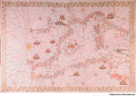
Photo by www.istitutodatini.it
Hydrographical institute
The 21 July to Genoa near the prestigious center of the Yacht Italian Club, the Hydrographical Institute of Navy of Genoa, Agency of Military Navy and Cartographic Organ of the State has introduced, derived from the nautical paper electronic (ENC), the innovative “nautical Papers for diporto” the waits from 134 years and today truth thanks to the most advanced technologies of the field.
The nautical, indispensable paper for navigation in emergency, like established from International Convention SOLAS of the 1974 (Safety Of Life At Sea, safeguard of the human life in sea) is only that one produced from the Hydrographical Service of State that, in the event of the Italy, from 1865 is entrusted Military Navy which they give 1872 manages it through the Hydrographical Institute.
In I furrow of the tradition and of the technological innovation that characterizes it, the Hydrographical Institute of Navy, beginning from 2004 has cured the distribution of the nautical paper electronic, equivalent for law to the traditional nautical paper and from today it is renewed ulteriorly with the production of the nautical paper for the diporto, derived from the paper electronic.
The Institute has center to Genoa, in Saint Fort George, where they operate approximately 250 military and civil persons between whom they assure the production of the nautical documentation of competence with one pulling anniversary of beyond 100.000 papers and 50,000 banns.
Italian Navy League - Run on-linens
The position of a ship comes characterized on the nautical paper (term that indicates in nearly the totality of cases the paper of Mercatore) by means of its coordinates latitude (j) and longitude (l).
Obvious the advantage of this unit of measure, in how much on the paper of Mercatore the distances can directly be measured in miles (that is in first of arc) with a calipers, using like compare features of the graduazione in first of the always present meridian on vertical sides of the nautical paper.
E' necessary but to have the shrewdness to take the calipers openings, to horse of the medium latitude of the area of the paper on which we carry out the measure of the distance, in how much the present graduazione on the meridian designed to the vertical margins of the paper represents the scale of the latitudes and has inasmuch as, on the paper of Mercatore, this scale is object of expansion to growing of the latitude.
If we are operating on a nautical scale paper small, it is necessary to take calipers openings limited and to change them varying of the latitude of the zone of the nautical paper where we are carrying out the measure.
Not to never use the scale of the longitudes brought back on the margins ups and downs of the nautical paper; we have inasmuch as, for the convergence of the meridians on the land sphere, their mutual distance diminishes to growing of the latitude (even if apparently on the paper of Mercatore the distance between they appears constant) and therefore the lengths of arc taken on the parallels do not correspond to the definition of nautical mile.
Italian Navy League - Run on-linens
The requirement to supply to the sailors a efficient and economic way in order to collect the elements and the data of interest for navigation, has carried to the development of the nautical papers, that they resolve the problem to represent, on a flat surface - the nautical paper - the points and the lines situate to you on the surface of the land sphere that instead is one surface () nearly spherical.
One characteristic to factor common of all the types of paper is the scale.
It indicates the relationship between the length of a whichever segment between two points, chosen on the paper, and the real distance of the same points on the land sphere.
As an example, with the scale 1:250.000, the length of a cm on the paper, it corresponds to the real distance of 2.500 meters.
With a 1:20.000 scale, a centimeter on the paper corresponds in reality to 200 mt.
As we will see this assertion is true single in determines fields to you of the nautical paper, in relation to the type of paper and the value of the scale, as indicated in the instructions brought back in the title it of every nautical paper.
With “low” scales, that is those that represent a wider portion of the land surface, the value of the scale (as factor of conversion of the distances measured to those real ones) are generally applicable without error in the zone center them of the paper and increasing errors in the farther areas from the zone are committed center them.
Benefits
Portolano Nauticard
Nauticard has tested MINE 168 and it united distributes it to the CD in Bundle offer of the papers.
The BOX OF the LANDINGS PLACE come opened with a click on the icona of the specific landing place wished that it is be posizionato on the paper with the classic symbol in magenta, represented from one sailing boat enclosed in a circle.
NAUTICAL PAPER:
EDITIONS THE SURF - PORTOLANI AND NAUTICAL PAPERS
News generates them, history, meteorology, cartography, services and infrastructures for the nautical one.
CORRESPONDENCE and QUIZ for the Examination of Nautical Patent One series of exercises, quiz and a questionnaire of aid to the preparation of the nautical patent.
VADEMECUM OF the DIPORTISTA NEW Biancucci Admiral EDITION WITH sure CD-ROM Andare in boat without problems with the law All the norms that discipline the diporto nautical with detailed esplicazioni, comments, varied, clear modulistica nautical, protect marine areas, aid in sea, etc
The LAWYER IN BOAT a guide to the Yachting Law di Andrea Petragnani Ciancarelli 130 pages the author faces in this book, subdivided in 13 understood them, many arguments relative you to the nautical norm, useful in order to resolve more attends problems lawyers of the diportisti.
The objective of the text, addressed mainly to the shipowners, but also to the operating ones of the nautical world, is that one to address the customer in order better to comprise and to manage sometimes the difficult nautical relationship between and straight.
The sea and its legal regimen, the stagionalità of the nautical one from diporto, the relationship with the coastal authorities, the contracts of buying and selling construction and of the units from diporto, the aid in sea, the insurance policies, are only some arguments face to you, making reference continuously the enforced norm: Code of the Nautical one from diporto, Navigation code and Civil code.
Worlds of Paper: Nautical Portolani and papers
Once it marks on the paper the arrival and departure points to you, the route was indicated from the rumbles; in the necessity, after a sure feature, to take an other direction, an other rumble was enough to fold the prow of the ship second.
Naturally it had at the same time to bring back on the paper the distance that was estimated to have covered, every day.
Ancient Geographic and Nautical papers
Banet Panadès Nautical Paper of the Mediterranean XVI century University of Bologna, Museum of Astronomy clicca on the image the nautical paper of Banet Panadès, cartographer maiorchino, filler a legenda with the name of the author, the place and the date in which Palermo was executed (, 1556); the parchment represents the river basin of the Mediterranean Mar, the Mar Nero, the Sea of Azov and the Atlantic coasts of Europe and the North Africa.
The nautical paper of Giulio di Cesar Petrucci, executed to Pisa in the 1571, similar one to that one of Panadès, rich is decorated with the rivers in green, the toponimi of the black or red cities in, lagos in blue and the twenty main ones in gold.
page type
Livorno was the last “nautical School” to develop itself between those Italians, re-entering in the production of the “medievalistica nautical cartography” that re-enters in the productive field of the Italian Schools of Genoa, Venice, Ancona, Messina and Naples.
The creation in native place of a cartographic laboratory attrezzatissimo and the nautical cartographic school was determined just from the navigatorie and war necessities of the Knights of Santo Stefano.
The founder of the School Livornese di Nautical Cartografia was a Dalmatian of Ragusa, Vincenzo Volcio di Demetrio, that he began just the job to Livorno in 1592.
Nautical banns and paper peach on Radiomarittimi.it
ITS Services Marittimi and Satellitari offers the supply of nautical instruments, paper nautical fishes and nautical papers realized from the main national and international institutes.
Moreover it offers to the own Customers the supply of traditional nautical instruments and marine banns, nautical nautical papers and paper peach realized from the main national and international institutes.
In the within of the supply of edge instrumentation we comprise also the sale of the material range: Italian and foreign marine banns, the relative material of correspondence, nautical the nautical cartography and paper fish, realized official cartography from the Hydrographical Institute of the Italian Navy, IMO (International Marine Organization), and from English Admiralty UKHO (United Kingdom Hidrografic Office).
The ARCS Navigator, nautical nautical papers and paper peach that is visualized through software appropriates makes interfacciano part to you or however, with the integrated systems of navigation.
Paper nautical ITS peach Services Marittimi and Satellitari.
The nautical papers and acquired paper peach have a limitless duration and are modernized to the moment of the sale.
ITS Radiomarittimi Services
ITS Services Marittimi and Satellitari, in the within of the supply of edge instrumentation comprises also the sale of realized official nautical cartography from the Hydrographical Institute of the Italian Navy, IMO and from English Admiralty UKHO.
ITS Services Marittimi and Satellitari offers the supply of nautical instruments, paper nautical fishes and nautical papers realized from the main national and international institutes.
ITS Services Marittimi and Satellitari operates in the field of nautical with the sale of instruments of navigation and the services for traditional the communication and advancing.
ITS Services Radiomaritttimi and Satellitari comprises also the sale of the material range: Italian and foreign marine banns, the relative material of correspondence, the official nautical cartography.
Categories:
- affittasi sea
- construction boats
- manifacturing boats
- boats in Sicily
- list boats
- houses sea
- nautical serene
- rent sailing boats
- nautical Rome
- accessories boats
- sea fen
- boats La Spezia
- calories fish sword
- common of vietri on the sea
- nautical Naples
- prices new boats
- prescription zuppa fish
- Liguria peach
- tour sea
- nautical sale
- prescription fish sword