Cities in Iraq
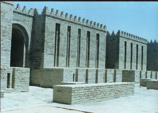
Babylon
Streets
of Babylon
It was Hammurabi who made Babylon
one of the great cities of the ancient world. Archaeologists have
discovered that in his city the streets were laid out in straight
lines that intersect approximately at right angles, an innovation
that bears witness to city planning and strong central government.

There were 24 streets
in Babylon, running either parallel to the river or at a
right angle to it. These streets were narrow, irregular,
ranging from about four to twenty feet in width with high
windowless walls on each side. The streets were not
paved, with the exception of the Processional Way, but
instead created with raw earth. Streets provided access
to houses, temples, and public buildings. They also
carried the burden of becoming the dumping grounds for
the city. The citizens of Babylon, not unlike those of
Renaissance England, threw their garbage and filth into
the streets. Then, they covered it up with layers of clay.
As a result, the streets of Babylon began to rise, and
eventually, houses needed to be built on higher ground.
Here are the two main roads of Babylon:
Aibur-Shabu: The
street known to the Babylonians as Aibur-shabu (the enemy
shall never pass) was the name of the road leading from
the north to the Ishtar gate. It was a broad paved road
that ran for 200m between high walls (the eastern wall of
the northern palace and the western side of the eastern
outer bastion).
Processional Way: The
most famous street was the "Processional Way"
which ran along the eastern side of the southern palace,
through the Ishtar gate and outside the inner town to a
special festival house called the Bit Akitu situated to
the north. The road climbs gently upwards towards gate.
Center of the roadway was laid with huge flagstones of
limestone, either side were slabs of reb beccia veined
with white, each paving stone has an inscription of
Nebuchadnezzar's dedication. On leaving the gate, the
Processional Way goes past the Southern Palace, sloping
downwards then some 900m south turns west between the
ziggurat enclosure and the Marduk temple towards the
Euphrates bridge built by both Nabonidus and
Nebuchadnezzar.
The way was lined with
figures of some 120 lions, the symbol of Ishtar in molded
glazed bricks. The lions on the Ishtar gate have a dark
blue background. They were either white with yellow mane
or yellow with red manes (now weathered to green).
The
Hanging Gardens of Babylon
The appeal of the
Hanging Gardens of Babylon lies with the human desire to
return to the simple and exquisite life in the Garden of
Eden, a life of Earthly Paradise. The myth of an original
Garden with perfumed trees and luscious fruits, birds and
animal life, and rivers of life giving waters is common
to many faiths including Christianity,
Judaism and Islam.
This mystical and peaceful Paradise holds a fascination
for the peoples of all ages and cultures, and which helps
us to understand the allure of the first Wonder, the
Hanging Gardens of Babylon.
The Hanging Gardens of
Babylon are alluded to in many ancient historical texts,
but it is the one Wonder which we are unsure even existed.
Current day archeologists are still examining the
evidence and trying to determine if and where these
Gardens existed. The oldest and best historical reference
to the Hanging Gardens of Babylon comes from the third
century BC, written by a priest of Babylon named Berosus.
He wrote an ancient document called the Babylonica,
which is a wonderfully extensive document about many
aspects of ancient Babylonian life. His source materials
were ancient Babylonian cuneiform records, which he
studied and interpreted. Cuneiform tablets were clay
plaques into which the written language of Babylonian
cuneiform was pressed using writing utensils made from
reeds. In his historical documents, Berosus wrote about
Babylonian astronomy, the history of the city, the
ancient creation myths and the great Epic of Gilgamesh.
He listed the dynasties of kings and the countries they
ruled; and he also gave us the most accurate record of
the great Nebuchadnezzar's rule during his many years as
King.
Hatra- City of Sun
Hatra is an archaeological site situated
in a depression in the northern jazirah of Iraq that lies between
the Tigris and Euphrates, 3KM to the west of Tharthar valley and 10KM
south west of the city of Mosul.
Nowadays, Hatra can be
reached through a 27KM road that branches off west of the
Baghdad - Mosul highway 85KM from Mosul.
It lies some 70KM from
the ancient city of Assur.
Hatra was an Arab
capital mentioned in a number of Aramaic writings.
The Kingdom of Hatra
was bordered to the east by the Tigris river, to the west
by the Euphrates river, to the north by Taurus Mountains
and to the south by Madain (Ctesiphon) outskirts.
The influence of
Hatra, however, had extended beyond Sinjar to reach
Khabur and Nsaibin, according to Arab writings.
Hatra has a special
geographic and strategic position that enabled it to
control trade and military routes along the Tigris and
Euphrates.
Hatra linked
Mesopotamia, with the Arab Gulf via a
land route. The rocky land of the Hatra, which made the
city as non-deplete source of stone used in the
construction of buildings and making of sculptures.
|

