The Unknown World Trail map
Part
V, The West: Atruaghin lands, Sind and Adri Varma
[Image: Ancient map]
This article follows previous installments detailing the south east
of the Known World (Five Shires, Karameikos, Ierendi, Minrothad and
Thyatis) in Threshold issue #13: http://pandius.com/Threshold_13.pdf,
the Broken Lands and Shadowlands in Threshold issue #14
http://pandius.com/Threshold_14.pdf,
the central nations (Darokin, Alfheim, Glantri and Ethengar) in
Threshold issue #15 http://pandius.com/Threshold_15.pdf,
and the eastern nations (Ylaruam, Rockhome and the Northern Reaches)
in Threshold issue #16 http://pandius.com/Threshold_16.pdf,
and to be completed with the north in Threshold issue #19. See the
introduction of the first article of this series for a full
explanation of the population maps and the purpose of these articles.
[Image: Known World
Populations]
http://pandius.com/Known_world_populations.png
[Image: Map key Populations]
Yellow: Settled lands, high human (or halfling) density,
average 75 humans (or halflings) per square mile.
Orange:
Borderlands, low human or halfling population, average 25 people per
square mile. May contain other races also, average 2.5 people per
square mile.
Purple: Humanoids, giants and others, average
25 per square mile. May also contain small number of humans, average
1.2 per square miles.
Green: Elves, average 20 per square
mile. May also contain small numbers of fairies, average 2.5 per
square mile.
Dark green: Elven borderlands, average 10
elves per square miles. Should also contain fairies, average 10 per
square mile.
Brown: Dwarves and/or gnomes, average 70 per
square miles. Each hex should be inhabited by 4,000-5,000 dwarves
with very low numbers of other creatures, if any.
Dark Brown:
Dwarven borderlands, average 15 per square miles. Should contain also
humanoids and other races, average 15 per square mile.
Blue:
Lupins or Rakasta, average 40 per square mile.
Yellow-green:
Humans and elves of Wendar, average 50 per square mile.
Gold:
Wendar borderlands, average 20 humans or elves per square mile. May
also contain fairies, average 5 per square miles.
Grey:
Oghriz of the Adri Varma, average 25 per square mile.
Light
orange: Mixed Oghriz, humanoids and humans, average 25 per square
mile.
[Image: Atruaghin
Populations]
http://pandius.com/Atruaghin_people.png
In the
Atruaghin lands, I have marked only towns and cities of the clans as
settled territory, meaning they are regions inhabited only by
humans. In the yellow hexes there are about 75 people per square mile
with a total population of 350,000 people. Some of these people will
be roaming the wilderlands most of the year, given the nomadic life
of most clans.
The borderlands in orange are about 560
hexes and should have a very low human density, about 10 per square
mile, and 10 members of other races, like centaurs, lupins, fairies
and wood imps, ents, harpies, orcs and other humanoids,
werecreatures, lizardmen and troglodytes, meaning about 350,000 human
inhabitants and 350,000 of other races.
The wilderlands
in purple, numbering about 470 hexes, should have about 25
inhabitants of other races per square mile and about 1 human, meaning
about 750,000 inhabitants of various races, mostly red orcs and other
humanoids, fairies and centaurs, lizardmen and troglodytes, and
30,000 humans.
The territory should be able to support about
1,000 dragons. My estimation of the population of the land is 730,000
humans, 300,000 red orcs, 150,000 other humanoids, 50,000 lupins,
50,000 centaurs, 50,000 other fairies, 150,000 lizardmen and 150,000
troglodytes, 200,000 other creatures which could include
werecreatures, geonids, rockmen, gyerians, tortles, crabmen,
brutemen, chameleon men, frogfolk, caymen or any other race the DM
could find appropriate. Canon products in fact have little or no
information about other people which could live in the Atruaghin
lands, and only red orcs, centaurs and werecreatures are mentioned.
Note also that the total square miles given in canon product, less
than 50,000, is clearly wrong. Looking at the 8 miles per hex canon
map, the total area is more like 70,000 square miles. The population
estimated in canon products is 231,000 human inhabitants, while
Simone Neri in his “Demografia Mystariana1
estimated about 280,000 inhabitants, mostly humans with some small
minorities of other races. As explained in the previous articles of
this series, I prefer to assume a much higher population density,
particularly for non-human races.
[Image:
Atruaghin Wilderlands]
Area:
320 x 28 miles, or 8,960 square miles.
Days to cross2:
3 days traversing the region or 25 days bordering the Plateau,
normally it is possible to cover only 12 miles per day due to the
difficult terrain.
Intelligent inhabitants: probably up to
225,000 (red orcs, ogres, kobolds, goblins, hobgoblins, bugbears,
geonids, gremlins, hill giants, harpies, lupins, troglodytes,
brutemen, werecreatures, and at least 120 dragons), with extensive
underground areas.
[Image:
View of the Orclands hills]
Caption: View of the
Orclands hills
In
Canon products:
- In GAZ14 there are no details about
the wilderlands of the Atruaghin lands.
- The Poor Wizard’s
Almanac lists only normal animals such as horses, buffalo, birds of
prey, jungle beasts, great cats and snakes. In 1011 AC the Clans are
invaded by rogue Alphatian wizards, but later free themselves.
-
In PC1 Tall Tales of the Wee Folk, centaurs are mentioned in the
Plateau. In PC4 Night Howlers, it is rumoured that the Atruaghin
would be able to turn into their totemic animals, suggesting a form
of lycanthropy.
- In TM2 The Eastern Countries Trail Map, a King
Hutapanca is mentioned. He could be a King of the Tiger clan, which
is however named as Naravipa Dagger Tooth in the Poor Wizard’s
Almanac.
In Fan productions:
- The
replica map of Atruaghin lands by Thorfinn Tait is stored here:
http://pandius.com/m_atrugh.html,
also contains explanations on the canon names encountered in the map.
- The Monstrous Atlas: The Atruaghin clans by Sheldon Morris is
here in the Vaults: http://pandius.com/ma_atru.html
- Fan Almanacs from AC 1014 to 1019 in the Vaults of Pandius
http://pandius.com/alm.html
include descriptions of Atruaghin and events, with the ascent of
Eelsha Spider’s Kiss to High Priestess of the Tiger Clan and
their raids on Darokin in 1014 AC. A humanoid invasion and a
surrender of the Tiger Clan to Darokinian and other clans’
forces in 1015 AC. A successful rebellion against the Church of
Atzanteotl among the Tiger Clan in 1019 AC, and a Darokinian gold
rush in the territory of the Bear Clan, with war brewing.
- Long
Runners, Royal Basset Hounds, Mongrels and Shag Head lupins from
Dragon Magazine #237 are indicated as present in the Atruaghin lands
by Simone Neri. According to Átila Pires dos Santos from
Threshold Magazine issue #2 History of the Lupins
http://pandius.com/histlupn.html
the local breeds are the Shunka Warakin and the Urd and Grey Kobolds
also live in the region.
- More fan developments and idea for the
Atruaghin lands can be found in the section of the Vaults of Pandius
http://pandius.com/atruagh.html
Area:
140 x 24 miles, or 3,200 square miles.
Days to cross: 3 days
traversing the region or 10 days bordering the Plateau, normally it
is possible to cover only 12 miles per day due to the difficult
terrain.
Intelligent inhabitants: probably up to 80,000 (gnolls,
other humanoids, undead, fairies, hill giants, geonids, gremlins,
harpies, lizardmen, troglodytes, brutemen, werecreatures and at least
50 dragons), with extensive underground areas.
[Image:
View of Bear clan village atop the Plateau]
Caption:
Bear clan village atop the Plateau
In
Canon products:
- In GAZ14 or other canon products
there is no information about this region, see above about canon
information on the Atruaghin territories.
In Fan
productions:
- See above
Area:
185 x 20 miles, or 3,700 square miles.
Days to cross: 2 days
traversing the region or 20 days bordering the coast, normally it is
possible to cover only 10 miles per day due to the difficult terrain.
Intelligent inhabitants: probably up to 95,000 (kobolds, gnolls,
other humanoids, hill giants, harpies, troglodytes, lizardmen,
brutemen and at least 50 dragons), with extensive underground areas.
[Image:
Turtle clan canoe]
Caption: Turtle clan canoe
meeting visitors
In
Canon products:
- In GAZ14 there is no canon
information about this region.
- Merrow and Kna are probably the
most common inhabitants of the coast, or so it can be deduced from
the map in PC3 The Sea People.
In Fan
productions:
- See region 1 above
Area:
160 x 80 miles, or 12,800 square miles.
Days to cross: 10 days
north - south or 20 days east - west, normally it is possible to
cover only 8 miles per day due to the difficult terrain.
Intelligent
inhabitants: probably up to 350,000 (humanoids, faeries, gremlins,
harpies, lizardmen, troglodytes, brutemen and at least 200 dragons),
with possible underground areas.
[Image:
Elk clan family]
Caption: Elk clan family in the
forest
In
Canon products:
- In GAZ14 this area is not described,
only named as The Singing Forest on the map. The Palace of Atruaghin
however is described in the Gazetteer as a connection between the
Outer and the Hollow Worlds.
- In Who’s Who Among Dragons
by Bruce Heard, published in Dragon Magazine #170 and reproduced in
the Vaults http://pandius.com/whoswho.html,
in the deep of the forest lies Atturamak, the realm dominated by
Attura, a 16-HD green dragon.
In Fan productions:
-
See region 1 above.
[Image: Sind
Populations]
http://pandius.com/Sind_people.png
In
Sind, I have marked as settled areas, in yellow, only the big
cities and their immediate vicinities. There are only about 130 such
hexes, but their density should be quite high, around 100 people per
square mile, therefore containing 830,000 inhabitants. In Jaibul
there are 12 hexes of high density, containing about 75,000 people.
The borderlands are extensive, about 700 hexes with a
population of 1,125,000 humans and about 125,000 non-humans. In
Jaibul there are about 85 hexes of wilderlands which should contain
135,000 human inhabitants and 15,000 non-human ones.
The blue
regions in the north of Sind are those inhabited by lupins and
rakasta, and should amount to about 350,000.
The wilderlands
of Sind, depicted in purple, are immense. There are about 2,340 hexes
of wilderlands which should contain 150,000 human inhabitants and
3,750,000 non-human inhabitants. Jaibul has 65 wilderland hexes for a
non-human population of about 100,000 intelligent creatures.
The
territory of Sind and Jaibul should be able to support more than
3,000 dragons.
My estimation of the total human population of the
region of Sind and Jaibul is therefore 2,315,000 inhabitants, which
is way higher than the 550,000 human inhabitants in Sind (plus the
same number of humanoids and minions of Hule) estimated in the Poor
Wizard’s Almanac. My estimation is not very far from the
about 2 million human inhabitants in Sind and Jaibul estimated by
Simone Neri in his Demografia.
Given the extension of the
wilderlands and borderlands in the region my estimation of the
non-human population, however, is way higher, reaching 4 million
intelligent creatures. These creatures should be lupins and rakasta,
gnolls, manscorpions, trolls, sphinxes, undead, efreets and djinns
(mentioned in the Poor Wizard’s Almanac ) shapeshifters
of various nature (mentioned in the History of Sind) bugbears,
gnolls, ogres (mentioned in the settled lands in X4 Master of the
Desert Nomads) and also red and grey orcs, thouls, gargoyles
(supposed by Simone Neri) adaptors, beholders, bhuts, faenare,
geonids, giants, harpies, mujina, nagpa, pooka, sidhe, tabi,
troglodytes, werecreatures (supposed by Sheldon Morris based on
nearby lands and the encounters in modules X4 and X5). The Explorer’s
Manual of Champions of Mystara Boxed Set mentions on page 18
Dylkes Sahib ("Mister Charming”), the legendary father of
all crocodiles, living in the Salt Swamp. I imagined him in Threshold
issue #9 as a huge black dragon with gatormen servants. Lizardmen,
caymen, chameleon men and brutemen could also be present in Sind, as
they are all creatures present in the B and X series of modules.
The
Wilderlands of Sind
[Image:
Sind Wilderlands]
http://pandius.com/Sind_wilderlands.png
Area:
56 x 72 miles, or 4,000 square miles.
Days to cross: 4 days east -
west or 5 days north - south, normally it is possible to cover only
12 miles per day due to the difficult terrain.
Intelligent
inhabitants: probably up to 100,000 (ogres, grey orcs, kobolds,
gremlins, manscorpions and at least 50 dragons), with possible
underground areas.
In
Canon products:
- In Champions of Mystara’s
Explorer Manual the mumlyket of Kadesh is briefly described on page
22.
- In the Poor Wizard’s Almanac Sind is briefly
described, flora and fauna listed is animal herds (cattle), giant
ants, bandits in the desert, basilisks, camels, cockatrices, djinn,
red dragons, efreet, elephants, ghouls, gnolls, giant lizards,
manscorpions, mummies, giant scorpions, shadows, sphinxes and trolls.
In the time of 1010-1013 AC Sind is occupied by the force of the
Master of Hule, but in the meantime the new religion of Gareth is
rising, and rebels rise against the occupants.
- The first part
of X4, Master of the Desert Nomads is set in Sind invaded by the
force of the Master of Hule (even if at the time Sind has not been
developed yet as a nation and is not mentioned as such) from
Pramayama to the Salt Swamp and the Sind desert.
In
Fan productions:
- The replica map of Sind by Thorfinn
Tait is stored here: http://pandius.com/m_sndjai.html,
also contains explanations on the canon names encountered in the map.
- The Monstrous Atlas: The Kingdom of Sind by Sheldon Morris is
here in the Vaults: http://pandius.com/ma_sind.html
- Fan Almanacs from AC 1014 to 1019 in the Vaults of Pandius
http://pandius.com/alm.html
include descriptions of Sind and events, with Sind freed from the
Master’s forces between 1016 and 1017 AC and the independence
of northern mumlykets.
- More fan resources on Sind can be found
in its section in the Vaults of Pandius: http://pandius.com/sind.html
2 - Kurish Massif (aka Amsorak Mountains)
Area:
480 x 96 miles, or 46,000 square miles.
Days to cross: 100 days
east - west or 20 days north - south, normally it is possible to
cover only 5 miles per day due to the difficult terrain.
Intelligent
inhabitants: probably up to 1,200,000 (giants, ogres, grey orcs, red
orcs, bugbears, kobolds, other humanoids, lupins, rakasta, gremlins,
tabi, troglodytes, brutemen and at least 700 dragons), with extensive
underground areas.
[Image:
Sindian battle against humanoids]
Caption: Sindian
battle against humanoids
In
Canon products:
- In Champions of Mystara’s
Explorer Manual the mumlykets of Kadesh, Peshmir and Gunjab are
briefly described on page 20-23. In the boxed set the mountains are
called Amsorak mountains, even if the map has Kurish Massif. Amsorak
could be the Darokinian name, and Kurish the Sindhi one.
- In
Dragon Magazine #247, the article “Rakasta of Mystara” by
Bruce Heard mentions Mountain Rakasta in the Kurish Massif.
In
Fan productions:
- See area 1 above
- In Dragon
Magazine #237, the article “Lupins of the Mystara setting”
introduces several breeds. Sind is not mentioned, but Simone Neri in
his “Demografia Mystariana” supposes almost all the breed
described for Glantri and the Savage Coast could also be present in
Sind. Atila Pires dos Santos created the Senjabi as a Sindian breed
here http://pandius.com/lupnbred.html
and in Threshold magazine issue #2, where he supposes also some Urd
kobolds could live in Sind as well as in Atruaghin lands. The Senjabi
should inhabit mostly Peshmir and the northern mumlykets.
- In
“History And Evolution Of Rakastas” by Simone Neri
http://pandius.com/rakhevol.html
rakasta and rakshasa inhabited Sind until their expulsion during the
revolt against the shapeshifters. I assume however many still inhabit
the northern mountains.
3 - The Desert of Baratkand
Area:
175 x 175 miles, or 31,000 square miles.
Days to cross: 14 days
east - west or north - south, normally it is possible to cover only
12 miles per day due to the difficult terrain.
Intelligent
inhabitants: probably up to 700,000 (ogres, grey orcs, gnolls,
kobolds, humans, gremlins, nagpa, tabi, manscorpions and at least 400
dragons), with possible underground areas.
[Image:
Baratkand desert]
Caption: View of the desert
Area:
400 x 36 miles, or 15,000 square miles.
Days to cross: 3 days east
- west or 30 days north - south, normally it is possible to cover
only 12 miles per day due to the difficult terrain.
Intelligent
inhabitants: probably up to 350,000 (red orcs, gnolls, kobolds,
geonids, brutemen, troglodytes, manscorpions and at least 200
dragons), with extensive underground areas.
[Image:
Sindian warriors fighting a red orc]
Caption:
Sindian warriors fighting a red orc
Area:
200 x 80 miles, or 16,000 square miles.
Days to cross: 50 days
east - west or 20 days north - south, normally it is possible to
cover only 4 miles per day due to the difficult terrain.
Intelligent
inhabitants: probably up to 400,000 (gatormen, lizardmen, caymen,
troglodytes, frogfolk, kobolds and other humanoids, manscorpions and
at least 250 dragons), with possible underground areas.
[Image:
View of the swamp]
Caption: View of the swamp
Area:
130 x 64 miles, or 8,300 square miles.
Days to cross: 2-8 days
east - west or 10 days north - south, normally it is possible to
cover only 12 miles per day due to the difficult terrain.
Intelligent inhabitants: probably up to 200,000 (gnolls, kobolds
and other humanoids, humans, sis’thik, manscorpions and at
least 120 dragons), with possible underground areas.
[Image:
Ruins in the desert]
Caption: Ruins in Shakarkand
Area:
88 x 72 miles, or 6,340 square miles.
Days to cross: 6 days east -
west or 7 days north - south, normally it is possible to cover only
12 miles per day due to the difficult terrain.
Intelligent
inhabitants: probably up to 150,000 (gnolls, kobolds and other
humanoids, humans, sis’thik, efreet, djinn, manscorpions and at
least 100 dragons), with possible underground areas.
Area:
290 x 40 miles, or 11,500 square miles.
Days to cross: 4 days east
- west or 29 days north - south, normally it is possible to cover
only 10 miles per day due to the difficult terrain.
Intelligent
inhabitants: probably up to 200,000 (gnolls, kobolds and other
humanoids, humans, sis’thik, efreet, djinn, desert ghosts,
manscorpions and at least 150 dragons), with possible underground
areas.
[Image:
Maharaja’s entourage]
Caption: Maharaja’s
entourage
Area:
180 x 50 miles, or 9,000 square miles.
Days to cross: 4 days east
- west or 15 days north - south, normally it is possible to cover
only 12 miles per day due to the difficult terrain.
Intelligent
inhabitants: probably up to 200,000 (gnolls, kobolds and other
humanoids, humans, sis’thik, efreet, djinn, manscorpions and at
least 130 dragons), with possible underground areas.
[Image:
Adri Varma Populations]
http://pandius.com/Adri_Varma_people.png
Foreword:
About Gulluvia and the Adri Varma Plateau
Gulluvia was
introduced in the first edition of the module B3 Palace of the Silver
Princess (orange cover) where the disappeared city of Haven was
placed in the Adri Varma plateau northwest of Glantri. Later the
module was moved to Karameikos in the (green cover) later edition and
both Gulluvia and the Adri Varma plateau were basically ignored by
later canon products (except for a brief mention in the Dragonlord
trilogy, set in 500 AC, about the Overlord’s army amassing in
the unnamed territory north west of Glantri4).
The Mystara fan community however filled the void and now there are a
lot of resources about the Adri Varma plateau, listed below, and also
a Gazetteer in Italian by Omnibius (Roberto Roma), translated into
English by Gary Davies and available in the
Vaults:
http://pandius.com/Adri_Varma.pdf
which compiles and expand the available fan resources. The Adri Varma
plateau is also inhabited by unique races, such as the oghriz (mixed
Neathar/Oltec humans, orcs and ogres), the stolari (cactus men), the
ungolwaith or sandfolk (four armed humanoids introduced in the module
DA3: “City of the Gods”) and the ubue (humanoids
with three heads, arms and legs which appear in the original edition
of B3).
In
Adri Varma, I have marked as civilized in yellow only the
human communities of Gulluvia and the town nearest to Glantri and
Sind. There are about 30 such hexes with should have a relative high
density (over 100 people per square mile) and a total population of
200,000, mostly humans with some humanoids and oghriz. I have marked
in orange (as borderlands) the rest of the territory more or
less controlled by Gulluvia. There are about 105 such hexes for a
population of about 170,000 people mostly humans with some humanoids
and oghriz.
The light orange hexes are instead inhabited
by oghriz, humanoids and humans, in roughly the same proportion with
a majority of humans in the south and oghriz in the north. A few
humanoids are integrated in the human or oghriz society, while some
are hostile to both. There are about 185 such hexes for a population
of 300,000 inhabitants.
The hexes in grey are those
inhabited mostly by oghriz with minorities of humans and humanoids.
The area of Sol-Klor, the oghriz city, should have a density of more
than 100 people per square mile. It is about 35 hexes wide and should
have 230,000 inhabitants. The rest of the grey hexes are inhabited by
nomadic oghriz and have therefore a much lower density, containing
about 400,000 inhabitants in 300 hexes.
The blue hexes are
inhabited by lupins and rakasta. There are about 230 such hexes which
should support a population of about 500,000 inhabitants.
Last,
the true wilderlands of the plateau, in purple, cover most of
its territory, 3,000 hexes with a density of about 20 people per
square miles and 3,750,000 inhabitants, mostly sandfolk, stolari,
manscorpions, ubue, giants, ogres, orcs, trolls, hobgoblins, goblins,
kobolds, bugbears, troglodytes, brutemen, lizardmen, geonids, faerie,
faenare, werecreatures and frogfolk. An estimation of the different
people inhabiting the plateau could be of 450,000 humans, 700,000
oghriz, 250,000 lupins, 250,000 rakasta, 500,000 sandfolk, 500,000
stolari, 300,000 orcs, 200,000 ogres, 200,000 hobgoblins, 200,000
goblins, 200,000 bugbears, 200,000 kobolds, 200,000 manscorpions,
200,000 ubue, 200,000 brutemen, 200,000 troglodytes, 100,000
lizardmen, 100,000 trolls, 100,000 frogfolk, 100,000 geonids, 100,000
fairies, including centaurs, 100,000 giants, 100,000 faenare, 100,000
werecreatures, undead and other intelligent races. The plateau should
also be able to support 3,500 dragons.
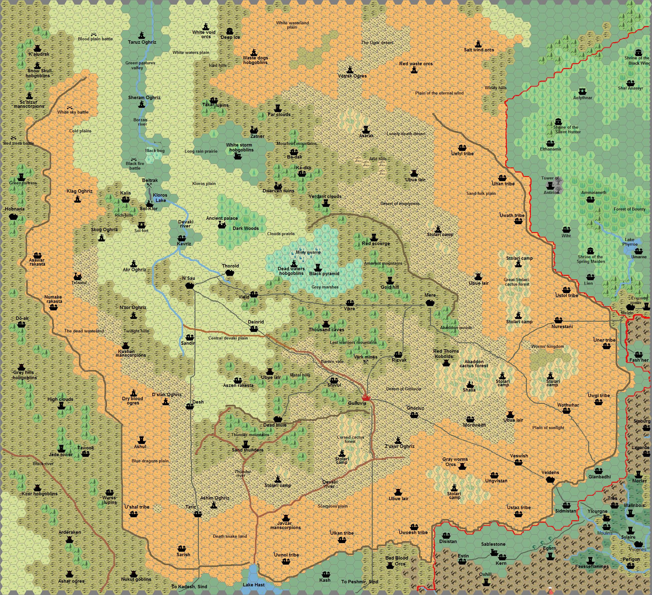
The
Wilderlands of Adri Varma
[Image:
Adri Varma
Wilderlands]
http://pandius.com/Adri_Varma_wilderlands.png
1 - Northern Wasteland
Area:
305 x 210 miles, or 64,000 square miles.
Days to cross5:
25 days north - south or 18 days east - west, normally it is possible
to cover only 12 miles per day due to the difficult terrain.
Intelligent inhabitants: probably up to 1,280,000 (oghriz, orcs,
ogres, hobgoblins, giants, other humanoids, lupins, sandfolk,
stolari, ubue, brutemen and at least 1,000 dragons), with extensive
underground areas.
[Image:
Northern desert with snow]
Caption: Northern desert
with snow
In
Canon products:
- This region is not described in the
original B3
In Fan productions:
- All
the available resources on the Adri Varma Plateau are stored here on
the Vaults of Pandius: http://pandius.com/adrivarm.html
- Sheldon Morris’ Monstrous Atlas
http://pandius.com/ma_adriv.html
list as intelligent inhabitants of the Plateau brownies, dragons,
dwarves, geonids, giants, hobgoblins, leprechauns, lupins,
manscorpions (scorpionfolk), nagpa, neanderthals (brutemen), ogres,
orcs, rakasta, sidhe, thouls, ubue. Other intelligent beings which
should inhabit the plateau are oghriz, sandfolk and stolari (from
other fan resources), centaurs, kobolds (as they appear in the
original B3), and possibly chameleon men, caymen, other fairies,
gargoyles, gyerians, hivebrood, other humanoids, lizard men,
troglodytes, werecreatures and any other creature mentioned in
adventures and modules set in the Known World.
- In my 8 miles
per hex map of the Plateau (http://pandius.com/adri.jpg)
I placed in this region mostly humanoids, lupins, brutemen, giants
and sandfolk.
2
- Adri Varma Hills
Area:
560 x 40-160 miles, or 56,000 square miles.
Days to cross: 70 days
north - south or 5-20 days east - west, normally it is possible to
cover only 8 miles per day due to the difficult terrain.
Intelligent
inhabitants: probably up to 1,120,000 (hobgoblins, goblins, giants,
lupins, rakasta, fairies, manscorpions and at least 700 dragons),
with extensive underground areas.
[Image:
Stream in the hills]
Caption: Stream in the hills
In
Canon products:
- This region is not described in the
original B3
In Fan productions:
- See
region 1 above.
- In my 8 miles per hex map of the Plateau
(http://pandius.com/adri.jpg)
I placed in this region mostly humanoids, lupins, rakasta, fairies
brutemen, giants and manscorpions.
3
- The Dark Wood and the Misty Swamp
Area:
150 x 80 miles, or 12,000 square miles.
Days to cross: 15 days
north - south or 8 days east - west, normally it is possible to cover
only 10 miles per day due to the difficult terrain.
Intelligent
inhabitants: probably up to 245,000 (hobgoblins, brutemen, fairies,
centaurs lizardmen, troglodytes, caymen and at least 180 dragons),
with extensive underground areas.
In
Canon products:
- The Misty Swamp was described on page
4 of the original B3. Fans later expanded the story about a
mysterious evil wizard living in the area.
In Fan
productions:
- See region 1 above, in particular
Atzri-Voca, Azcan Lich by Christopher Cherrington
http://pandius.com/atzrivoc.html
- In my 8 miles per hex map of the Plateau
(http://pandius.com/adri.jpg)
I placed in this region the Black Pyramid of Atzri-Voca, hobgoblins
and fairies. The Ancient Palace marked on the map is the original
location of Princess Argenta palace of Haven from B3.
4
- The Thousand Caves
Area:
120 x 40 miles, or 5,000 square miles.
Days to cross: 15 days
north - south or 5 days east - west, normally it is possible to cover
only 8 miles per day due to the difficult terrain.
Intelligent
inhabitants: probably up to 120,000 (humanoids, brutemen,
troglodytes, manscorpions and at least 75 dragons), with very
extensive underground areas.
[Image:
Painting of humanoids and oghriz fighting]
Caption:
Painting of humanoid and oghriz fighting
In
Canon products:
- This region was described on page 4
of the original B3 under Moorfowl mountains. The text says the former
dwarven mines have been overrun by evil creatures.
In
Fan productions:
- See region 1 above.
- In my 8
miles per hex map of the Plateau (http://pandius.com/adri.jpg)
I placed in this region The Thousand Caves, an extensive underground
network of former dwarven and gnomish mines, now mostly occupied by
humanoids and troglodytes.
5
- Western Gulluvia
Area:
120 x 80 miles, or 10,000 square miles.
Days to cross: 15 days
north - south or 10 days east - west, normally it is possible to
cover only 8 miles per day due to the difficult terrain.
Intelligent
inhabitants: probably up to 120,000 (rakasta, giants, ubue, humanoids
and at least 150 dragons), with extensive underground areas.
[Image:
Western Gulluvia in spring]
Caption: Western
Gulluvia in Spring
In
Canon products:
- The village of Dead Mule was briefly
described on page 4 of the original B3, as a former peaceful town of
miners occupied by Gulluvia soldiers.
In Fan
productions:
- See region 1 above.
- In my 8 miles
per hex map of the Plateau (http://pandius.com/adri.jpg)
I placed here the Aszen rakasta, ubue lairs and giants in the
stronghold of Sand Thunders.
6
- The Red Waste of the South East
Area:
400 x 160 miles, or 64,000 square miles.
Days to cross: 13 days
north - south or 35 days east - west, normally it is possible to
cover only 12 miles per day due to the difficult terrain.
Intelligent inhabitants: probably up to 1,300,000 (rakasta,
giants, ubue, humanoids and at least 1,000 dragons), with possible
underground areas.
[Image:
View of the Stolari desert]
Caption: View of the
Stolari desert
In
Canon products:
- This region is not described on page
4 of the original B3, as the desert depicted on the Plateau in later
canon maps is not present in the module. The town of Velders is
briefly described as occupied by Gulluvia and subject to humanoid
raids.
In Fan productions:
- See
region 1 above.
- In my 8 miles per hex map of the Plateau
(http://pandius.com/adri.jpg)
I placed here mostly the Ungolwaith (sandfolk), the stolari, ubue,
manscorpions with some tribes of oghriz, ogres, orcs, kobolds and
some human villages. (Velders is wrongly spelled Veldens on my map.
|
|
[Image:
Ancient map]
|
|
|
|
[Image:
Known World Populations]
|
https://drive.google.com/open?id=0B4FkxRFtCZ22alVTYUNxZUhlLXM |
|
|
[Image:
Map key Populations]
|
https://drive.google.com/open?id=0B4FkxRFtCZ22ZFMwX2pMZEhuaEk |
|
|
[Image:
Atruaghin Populations]
|
https://drive.google.com/open?id=0B4FkxRFtCZ22cnRJZ3VhQ1V1cHM |
|
|
[Image:
Atruaghin Wilderlands]
|
https://drive.google.com/open?id=0B4FkxRFtCZ22X0Q1cDZGS0xBTFk |
|
|
[Image:
Horse clan riders]
|
|
|
|
[Image:
View of the Orclands hills]
|
|
|
|
[Image: View of
Bear clan village atop the Plateau] |
|
|
|
[Image: Turtle
clan canoe] |
|
|
|
[Image: Elk
clan family] |
|
|
|
[Image: Sind
Populations] |
https://drive.google.com/open?id=0B4FkxRFtCZ22YVJSaXJwNGVkZTA |
|
|
[Image: Sind
Wilderlands] |
https://drive.google.com/open?id=0B4FkxRFtCZ22MkoyTUpLUURCX1E |
|
|
[Image: Sindian
battle against humanoids] |
|
|
|
[Image:
Baratkand desert] |
|
|
|
[Image: Sindian
warriors fighting a red orc] |
|
|
|
[Image: View of
the swamp] |
|
|
|
[Image: Ruins
in the desert] |
|
|
|
[Image:
Maharaja’s entourage] |
|
|
|
[Image: Adri
Varma Populations] |
https://drive.google.com/open?id=0B4FkxRFtCZ22WThpSXNsWmVMX0E |
|
|
[Image: Adri
Varma Wilderlands] |
https://drive.google.com/open?id=0B4FkxRFtCZ22bWg0OXNLdmZMd0U |
|
|
[Image:
Northern desert with snow] |
|
|
|
[Image: Stream
in the hills] |
|
|
|
[Image:
Painting of humanoids and oghriz fighting] |
|
|
|
[Image: Western
Gulluvia in spring] |
|
|
|
[Image: View of
the Stolari desert] |
1Available here: http://www.kofn.net/download/ambientazioni/demografiaMystariana.pdf in Italian only, but part of it was updated and translated in English in Threshold issue #1 http://pandius.com/Threshold_1.pdf and #3 http://pandius.com/Threshold_3.pdf.
2By foot with light encumbrance. However as this refers to difficult wilderlands, often without trails, the movement rate on horses should not be much different. Note also that the chance of getting lost in these areas, unless the PCs have a good map or a good guide, should be very high, so the actual travel time could easily double.
3The destructive aspect of Ixion in Champions of Mystara boxed set, page 15 of the Explorer’s manual.
4See also David Keyser’s Dragonlord Chronicles - Detailed Summaries http://pandius.com/dlrdchrn.html
5By foot with light encumbrance. However as this refers to difficult wilderlands, often without trails, the movement rate on horses should not be much different. Note also that the chances of getting lost in these areas, unless the PCs have a good map or a good guide, should be very high, so the actual travel time could easily double.
.jpg)
.jpg)