The Unknown World Trail map
Part
III, The Central lands: Darokin, Alfheim, Ethengar and Glantri
This
article follows the first installment detailing the south east of the
Known World in Threshold issue #13 and the Broken Lands and
Shadowlands in issue #14. See the introduction of the first article
of this serie for a full explanation of the population maps and the
purpose of these articles.
[Image:
Known World Populations]
http://pandius.com/Known_world_populations.png
[Image:
Map key Populations]
Yellow: “Civilized” lands, high human (or
halfling) density, average 75 humans (or halflings) per square
mile.
Orange: Borderlands, low human or halfling
population, average 25 people per square mile. May also contain other
races, average 2.5 people per square mile.
Purple:
Humanoids, giants and others, average 25 per square mile. May also
contain small numbers of humans, average 1.2 per square miles.
Green: Elves, average 20 per square mile. May also contain
small numbers of fairies, average 2.5 per square mile.
Dark
green: Elven borderlands, average 10 elves per square miles.
Should also contain fairies, average 10 per square mile.
Brown:
Dwarves and/or gnomes, average 70 per square miles. Each hex should
be inhabited by 4,000-5,000 dwarves with very low numbers of other
creatures, if any.
Dark Brown: Dwarven borderlands,
average 15 per square miles. Should also contain humanoids and other
races, average 15 per square mile.
Blue: Lupins or
Rakasta, average 40 per square mile.
Area: 220 x 25 miles, or 5,500 square miles.
Days to cross3:
55 days east-west or 7 days north-south, normally it is possible to
cover only 4 miles per day due to the difficult terrain.
Intelligent
inhabitants: probably up to 145,000 (giants, bugbears, gnolls, orcs,
ogres, faenare, harpies, werecreatures and at least 80 dragons), with
extensive underground areas.
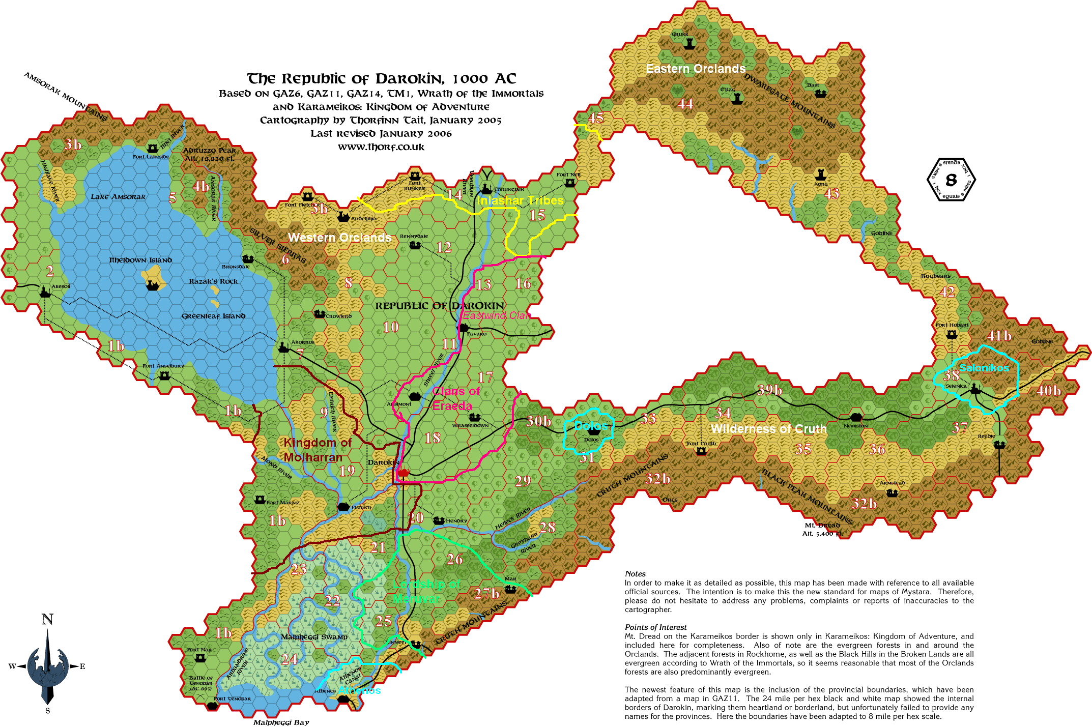
In Canon products:
-
In Gazetteer 11 The Republic of Darokin the region is briefly
described on page 7 and 8 of the DM’s guide, while Fort
Lakeside is described on page 41. The medium height is given at
12,000 feet (3,658 meters) but in the Trail Map 1 Adruzzo Peak is
indicated as the tallest mountain at 18,820 feet (5,736 meters).
-
A Master level adventure on page 58 deals with the demon Razrog who
now occupies the abandoned Itheldown island in Lake Amsorak. The
other two islands are described on pages 45 and 50 of the DM guide. A
detailed view of the islands is also included in the map, replicated
by Thorfinn Tait http://pandius.com/m_msorak.html
- Part of the adventure The Immortals’ Fury takes places in
Corran keep, built on the mountains of this region and pillaged by
monsters long ago. The PCs encounter intelligent Lightning zombies
and retrieve the Shield of Benekander. After the adventure, it is
suggested that Jeddarin Corran will rebuild the keep, while the
zombies may be helped by Nyx to establish a home elsewhere.
- The
adventure in Dungeon magazine #51, The Witch of Windcrag, against an
harpy, could be set here or near one of the other mountain chains of
region 3 and 4.
- According to the Dragonlord Chronicles by
Thorarrin Gunnarsson, the renegade black dragon Murodhir had a
kingdom in the mountains north of Lake Amsorak before he was killed
by the Dragonlord around 500 AC, see also the detailed summary of the
trilogy by David Keyser: http://pandius.com/dlrdchrn.html.
In Fan productions:
-
The replica map of Darokin by Thorfinn Tait
http://pandius.com/m_darokn.html
gathers all the available canon geographical information on the
Republic.
- The Republic is described in the fan almanacs from
1015 AC http://pandius.com/darokin.html#almanac
and there are events set in the nation, see also Harri Maki’s
list of events http://pandius.com/almindex.html
and the 1019 AC Almanac, featuring peace talks with the Shadow elves
http://pandius.com/1019kla.html#kla11c
- The Codex Immortalis by Marco Dalmonte, Book Two
http://pandius.com/Codex2e.pdf,
deals with the Darokin pantheon on page 84.
- For a list of
monsters, check Sheldon Morris’ Monstrous Atlas
(http://pandius.com/ma_daro.html).
-
Mike Phillips mapped the whole of Darokin in 2 2/3 miles per hex
http://pandius.com/m_dkn223.html,
including wilderlands and borderlands.
- The extensive work done
on the History of Darokin by fans, particularly Geoff Gander, John
Calvin, Greg Weatherup, Sheldon Morris and Aaron Nowack, published in
the Vaults http://pandius.com/darokin.html#history
is often relevant for most of the wilderlands of Darokin. A summary
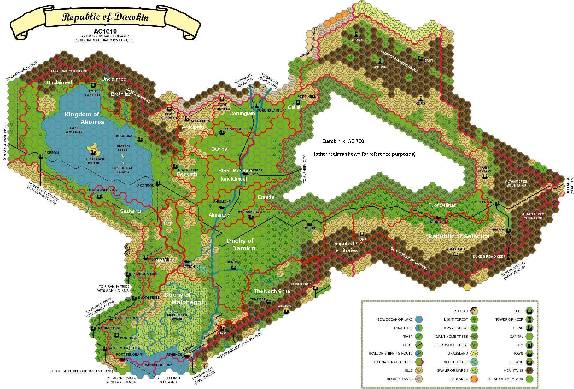
can also be found in my article Past Ages of the Known World in
Threshold issue 12. Maps of Darokin in 300 BC
http://pandius.com/darokin8300bclabels3ya.png,
685 AC http://pandius.com/m_dk685a.html,
700 AC http://pandius.com/darokinmod6xh.jpg
and 800 AC http://pandius.com/m_dk800a.html
were also made by Geoff Gander and others.
- The lost elven realm
of Brethilad http://pandius.com/brethild.html
was created by Geoff Gander north of the lake.
- Several Darokian
NPC’s were developed by fans and are published in the Vault of
Pandius: http://pandius.com/npcs.html#daronpcs
Some of them, particularly werecreatures, are particularly useful as
inhabitants of borderlands and wilderlands.
In Canon products:
-
In Gazetteer 11 the region is briefly described on page 7 of the DM’s
guide. The description of Tenobar on page 44 is also relevant and the
swamp is further described on page 45 and 47, where it is described
as inhabited by lizard men, ogres, orcs, hobgoblins, goblins,
kobolds, trolls, human bandits and cultists, and many monsters, and
considered an extremely dangerous place.
- The adventure Action
on the Athenos on page 55 of the DM’s guide is set in this
region.
- In the article Who’s Who Among Dragons, written
by Bruce Heard in Dragon magazine #171 and available also here
http://pandius.com/whoswho.html,
the swamp was revealed to be the domain of Thalkor, a powerful black
dragon. About these powerful dragons, see also my article Who’s
Who in the Wyrmsteeth part 2 in Threshold issue #9.
In Fan productions:
-
Mike Phillips made a map of the region called Westerlands
http://pandius.com/m_westln.html
with details on the borderlands and the swamp populations, later
detailing it further in 2 ⅔ mph
http://pandius.com/m_malphs.html
and describing some villages http://pandius.com/malphvlg.html.
Mike also described his campaign in the region
http://pandius.com/darochrn.html,
which started with an expanded version of Action on the Athenos.
-
Morphius Shadowleaf made a detailed map of the Malpheggi Swamp
available at the Vaults of Pandius http://pandius.com/malph.jpg
and also detailed some dangers of the swamp
http://pandius.com/malph_sp.html
- Carl Quaif created The Sisterhood of the Fens
http://pandius.com/fensistr.html
for this region
- Sheldon Morris made a Monstrous Atlas also for
the swamp http://pandius.com/ma_malp.html
3
- Cruth mountains, Black Peaks and Canolbarth borderlands
Area: 430 x 10-40 miles, or 9,000 square miles.
Days to cross: 100
days east-west or 7 days north-south, normally it is possible to
cover only 4 miles per day due to the difficult terrain.
Intelligent
inhabitants: probably up to 235,000 (giants, bugbears, gnolls, orcs,
ogres, faenare, harpies, werecreatures and at least 130 dragons),
with extensive underground areas.
Area: 330 x 25-120 miles, or 30,000 square miles.
Days to cross:
80 days east-west or 15 days north-south, normally it is possible to
cover only 4 miles per day due to the difficult terrain.
Intelligent
inhabitants: probably up to 750,000 (giants, bugbears, gnolls, orcs,
ogres, faenare, harpies, werecreatures and at least 400 dragons),
with extensive underground areas.
In Canon products:
-
In Gazetteer 11 the region is briefly described on page 7 of the DM’s
guide. The ruins of Ardelphia are described on page 33. The Orclands
and the humanoid fortresses are described on the following pages.
-
The altitudes of these mountains are not indicated in canon sources,
but as Mount Tarsus in Thyatis is 11,380 feet (3,469 meters) and the
Makkres in Rockhome are up to 15,000 feet (4,572 meters), probably
the tallest mountains here would reach up to 10,000 feet (3,048
meters).
- The adventure Orclands on page 56 of the DM’s
guide is set in this region.
- The adventure The Hand of Thar on
page 57 of the DM’s guide is set in this region.
- The
adventure DA1 Adventures in Blackmoor starts along the border to
continue in the Broken Lands and to ancient Blackmoor.
- The
adventure in Dungeon magazine #46, Dovedale, could be set in a
borderlands north of Selenica, or in the previous region 3.
- The
AD&D adventure Janx’s Jinx in Dungeon magazine #56 is meant
to be set in the same area as the above.
- The Tower of Doom
videogame begins in this region and continues in the Broken Lands,
and the sequel Shadow over Mystara is partially set in the Orclands.
In Fan productions:
-
The Voyage of the Discovery by Robin takes place in this region:
http://pandius.com/discvoyg.html
and she also made a 1mph map of Ardelphia to Corunglain
http://pandius.com/rdlpcrng.html
and obviously her ongoing 1mph map of the Upper Broken Lands, already
mentioned in Threshold issue #14, touches and details this region as
well.
- Geoff Gander wrote an adventure titled The Secret of the
Callair Hills available for sale on DriveThru RPG, which can be
easily set in this region as he explains in the Vaults:
http://pandius.com/callairh.html
-
A geographic entry for the Orclands was included in the 1015 fan
almanac and all those following, and is published at the Vaults of
Pandius http://pandius.com/orcland2.html
- Possible new developments for the Orclands humanoids were
imagined by Gordon McCormick in The Vision of Truth and Light
http://pandius.com/vistruth.html
and by me in The Tale Bringer (A Kingdom of Humanoids)
http://pandius.com/talebrik.html
- Sean Meaney developed the City State of Xorg
http://pandius.com/City_State_of_Xorg.doc
Alfheim
Area: 30 x 300 miles, or 9,000 square miles.
Days to cross4:
About 7 days east-west or 60 days following the border, normally it
is possible to cover only 5 miles per day due to the difficult
terrain.
Intelligent inhabitants: probably up to 200,000 (elves,
fairy folk, faenare, humanoids, aranea, gremlins, harpies,
werecreatures and at least 120 dragons), possibly with underground
areas.
In Canon products:
-
In Gazetteer 5 The Elves of Alfheim the good magic points of
Misthaven, Shadowdown and Algorn’s Last Stand are described, as
the nearby clanholds. According to Bruce Heard’s answer in
Dragon magazine #189, the good magic points will go dormant after the
Shadowelf conquest of Alfheim (described in the Wrath of the
Immortals boxed set), while the bad magic points will remain active.
- The adventure The Grand Tour on page 80 of the DM’s guide
starts near Shadowdown, then moves to all the clanholds of Alfheim.
-
The adventure The Nithian Lich on page 91 takes places in the town of
Shadowtree near the lakes of Selinar in the east of Alfheim.
- The
Expert adventure Rough Play on page 95 of the DM’s guide deals
with the Dwarven organization The Thorns active on this border of
Alfheim.
- In the module O2 Blade of Vengeance the Emerlas, the
northern region of Alfheim, is described in detail with a family of
red dragons as the main antagonist.
- The module CM7 The Tree of
Life starts in the forest of Selinar in Eastern Alfheim.
- The
module B7 Rahasia could easily be set in this region of Alfheim.
-
In the Dragonlord Trilogy by Thorarinn Gunnarsson, near Shadowdown
there is the monastic community of Silvermist, apparently inhabited
by elven priests of Terra, but in reality also a meeting point for
dragons and followers of the Great One.
- The Dungeon Magazine #1
adventure The Elven Home, featuring a treant and stirges, could be
set in this region or in other borderlands of Alfheim.
In
Fan productions:
-
The replica map of Alfheim by Thorfinn Tait
http://pandius.com/m_lfheim.html
gathers all the available canon geographical information on the
Realm, and the same for Aengmor http://pandius.com/m_engmor.html.
-
Aengmor is described in the fan almanacs starting in 1015 AC
http://pandius.com/aengmor.html#almanac
with events set in the nation. See also area 1 of Darokin above and
1019 AC events, including the Ceremony of Reconciliation
http://pandius.com/1019fla.html#fla12e
- The Codex Immortalis by Marco Dalmonte, Book Two
http://pandius.com/Codex2e.pdf,
deals with the Alfheim pantheon on page 82.
- For a list of
monsters, check Sheldon Morris’ Monstrous Atlas
http://pandius.com/ma_alfm.html
- Threshold issue #10 was dedicated to elves and contains
articles on the Elven Calendar and Elven Migrations, by me, Elven
Class Variants, by Craig Antoun, and the Fall and Rise of Canolbarth,
by Robin, detailing the fate of the forest after the Shadowelves’
conquest.
- The Demise of the Great Canolbarth forest by Robin
http://pandius.com/m_cbrth.html
is also published on the Vaults of Pandius, as her detailed 1 mile
per hex map of Alfheim http://pandius.com/m_cbrth1.html
which has a lot of locations and ideas about the Elven Kingdom.
-
More discussions and contributions to the future of Alfheim and
Aengmor can also be found in this section
http://pandius.com/aengmor.html#campaign
of the Vaults of Pandius.
- See also Elven Language by Jonathan
Nolan http://pandius.com/elflang.html,
Trees of Life in Mystara http://pandius.com/treelife.html
and the article The Lost Origins of the Elves in Threshold issue #12
by LoZompatore.
[Image:
Deer in the forest]
2 - Thornbush and the River of Monsters
Area: 25 x 80 miles, or 2,000 square miles.
Days to cross: About
14 days east-west or 4 days north-south, normally it is possible to
cover only 6 miles per day due to the difficult terrain.
Intelligent
inhabitants: probably up to 35,000 (elves, fairy folk, faenare,
humanoids, aranea, gremlins, harpies, werecreatures and at least 30
dragons), with possibly underground areas.
In Canon products:
-
In Gazetteer 5 The Elves of Alfheim, the good magic point of Dewdrop
is described, as is the bad magic point of Thornbush, which
constantly produces monsters. The Sump, a mile wide and thousand feet
deep depression that drains water, is described on page 23, as is the
Weir, a two mile long fence to keep inhabitants of the River of
Monsters out of the Sump.
- The adventure The Great Hunt on page
77 of the DM’s guide is related to Thornbush.
- The Basic
scenario Defend the Weir and the Master adventure Into the Bad Magic
Point on page 95 of the DM’s guide take place in this region.
- In the module X10 Red Arrow, Black Shield, the Alfheim mission,
which liberated the tomb of King Alevar from a red dragon, is located
in the “denser part of the forest”, which could be this
area or one of the other wilderlands.
In
Fan productions:
-
See area 1
Area: 16 x 32 miles, or 400 square miles.
Days to cross: About 8
days east-west or 4 days north-south, normally it is possible to
cover only 4 miles per day due to the difficult terrain. The region
also has traps.
Intelligent inhabitants: Less than 8,000 (mostly
elves, fairy folk, faenare and at least 10 dragons in the service of
the army), with possibly underground areas.
In Canon products:
-
In Gazetteer 5 The Elves of Alfheim the good magic point of Ironbark
is described as the site of an elven victory against Darokinians and
a site favourable to reversal and defensive magic.
In
Fan productions:
-
See area 1
4 - Southern Alfheim and Dragontree
Area: 10 x 240 miles, or 2,900 square miles.
Days to cross: About
2 days north-south or 50 days following the border, normally it is
possible to cover only 5 miles per day due to the difficult terrain.
Intelligent inhabitants: probably up to 60,000 (elves, fairy
folk, faenare, humanoids, aranea, gremlins, harpies, werecreatures,
beastmen and at least 45 dragons), with possibly underground areas.
In Canon products:
-
In Gazetteer 5 The Elves of Alfheim the good magic points of Dream
Land, Glowtree and Turnclaw are described, as is the bad magic point
of Dragontree. The beast men invasion of the wizard Illodius of 550
AC started in Turnclaw. Beastmen and werecreatures could still be
present in the region. According to a Bruce Heard’s answer in
Dragon magazine #189, the Dream Land will be removed from Mystara
after the Shadowelves conquest of Alfheim.
- The module CM9 Legacy
of Blood takes place in Fenhold, near Alfheim’s southern
border.
- The supplement PC1 Tall Tales of the Wee Folk,
describes in detail the region of Dream Land
- The Dungeon
Magazine #26 adventure Caravan Guards, featuring bhuts, is set in the
Darokian road near the southern border of Alfheim.
In
Fan productions:
-
See area 1
[Image:
Deep of the woods]
5 - Stalkbrow and the Selinar hills
Area: 16 x 80 miles, or 1,500 square miles.
Days to cross: About 4
days north-south or 20 days east-west, normally it is possible to
cover only 4 miles per day due to the difficult terrain.
Intelligent
inhabitants: probably up to 30,000 (elves, fairy folk, faenare,
humanoids, goblins, aranea, gremlins, harpies, werecreatures and at
least 20 dragons), with possibly underground areas.
In Canon products:
-
In Gazetteer 5 The Elves of Alfheim the good magic point of Goblin
Park is described, as is the bad magic point of Stalkbrow. The alien
goblins which invaded in 700 AC could still be present or reappear in
the area. Undead, nightmare creatures or fiends could be appropriate
for Stalkbrow.
- See area 1 about the module CM7 and the
Gazetteer adventure The Nithian Lich, set near this region.
In
Fan productions:
-
See area 1, also in Threshold issue #10, DesertNomad wrote the
article “The Stalkbrow Bad Magic Node”, describing the
area and proposing to place there the module CM5 Mystery of the Snow
Pearls. Gyerians are present in the module, so a population of them
could live in Alfheim.
I
have depicted most of Ethengar as borderlands, 840 orange
hexes, an enormous territory claimed and inhabited by the nomadic
Ethengarians, but shared with other intelligent creatures and wild
animals, monsters and spirits. I have considered civilized areas in
yellow
to only be the trade road that goes to the Heldann territories,
Vestland, Rockhome and Darokin, for a total of 75 hexes. The
Ethengarians patrol it in force, making it one of the safest routes
of the Known World. There are five big wilderlands for a total of 330
hexes, depicted in purple.
Estimations of the Ethengar population in the Poor Wizard’s
Almanac and in the Demografia Mystariana of Simone Neri give a figure
of slightly more or slightly less than 300,000, with a very low
density. I disagree because Ethengar is one of the most ancient
nations of the Known World, so even if the Ethengarians have
maintained a traditional nomadic lifestyle, I expect them to be
highly organized in their environment, and therefore with quite
advanced magic, defensive systems, and medicine, making it unlikely
they would have a very sparse population.
My estimation therefore
is a relative high density along the trade roads, with about 200,000
people, almost all humans except for some dwarven or elvish visitors.
The density of this area is still quite lower than the other
civilized areas of the Known World, at about 40 people per square
mile. The borderlands should have a density quite lower than other
similar regions with substantial populations, but still with only 15
people per square mile they should be able to support at least
800,000 inhabitants, mostly humans with about 50,000 other
intelligent creatures, mostly humanoids, centaurs, fairy folk,
faenare and/or gyerians, werecreatures and undead.
The
wilderlands should have a similar density, but humans should be
almost absent and the 400,000 inhabitants should be composed entirely
of humanoids, centaurs, fairy folk, faenare, werecreatures and the
Spirits of the Ethengarian traditions. These spirits could be pookas
or fairy folk, as the DM prefers. In total the steppes should be able
to support 1,000,000 Ethengarians or slightly less, and 450,000 other
intelligent inhabitants, with about 1,200 dragons.
The
Wilderlands of Ethengar
Area: 32 x 80 miles, or 2,500 square miles.
Days to cross: About 4
days north-south or 10 days east-west, normally it is possible to
cover 8 miles per day on foot, with high chances of getting lost.
Intelligent inhabitants: probably up to 50,000 (orcs, trolls and
other humanoids, centaurs, fairy folk, faenare and/or harpies or
gyerians, werecreatures and at least 20 dragons), with extensive
underground areas.
In Canon products:
-
In Gazetteer 12 The Golden Khan of Ethengar the Tanguts are said to
inhabit a tunnel system, and are allied to Moghul Khan of Yellow
Orkia. Taijits pay Moghul Khan to attack the Yakkas. Their number as
given is only 240, but I would raise it considerably.
- On page
43 of the DM’s guide the animals common in the steppes are
bear, camel, wild cat, chameleon lizard, dog, eagle, falcon, giant
boar, gerbil, wild goat, hawk, horse, lion, monkey, owl, sheep,
snake, swan, tiger, wolf, and yak. Spirits or pookas in the humanoid
shapes of these animals are therefore appropriate for the
wilderlands.
- The adventure Welcome to the Lands of the
Ethengars on page 51 could begin near this region.
- The module
BSOLO Ghost of Lion Castle, is set in Ethengar and could be
appropriate for this region.
- Dragon Magazine #237 does not
mention any specific lupin breed in Ethengar, but as there are
several in Glantri, Heldann and Norwold it is likely some also live
in the steppes. A lupin similar to the Tibetan Mastiff
https://en.wikipedia.org/wiki/Tibetan_Mastiff
would be appropriate. Rakasta could also be present in the steppes.
In
Fan productions:
-
The replica map of Ethengar by Thorfinn Tait
http://pandius.com/m_ethngr.html
gathers all the available geographical information on the steppes
-
See also the Monstrous Atlas
of the Ethengar Khanates by Sheldon Morris
http://pandius.com/ma_ethn.html
- The Ethengar Khanates are described in the fan almanacs from
1015 AC http://pandius.com/ethengar.html#almanac
and there are events set in the steppes, see also Harri Maki’s
list of events linked in the first area of Darokin and the 1019 AC
Almanac, featuring a raid on the Heldannic lands
http://pandius.com/1019amb.html#amb12f
- The Codex Immortalis by Marco Dalmonte, Book Two
http://pandius.com/Codex2e.pdf,
deals with the Ethengar pantheon on page 86.
- Sean Meaney
imagined an Ethengar
Invasion of insects carrying fungus from Glantri
http://pandius.com/ethinv.html
- Centaurs in Ethengar are described by Lost Woodrake
http://pandius.com/eth_cent.html
and by Christopher Richard Davies http://pandius.com/ethcent2.html
in the Vaults of Pandius.
- Development of an Ethengarian air
force of pegasus and other flying creatures is imagined by Sharon
Dornhoff http://pandius.com/ethieair.html
and by John Hare http://pandius.com/ethiear2.html
in the Vaults.
[Image:
Ethengar grassland]
Caption:
Ethengar grassland
Area: 64 x 64 miles, or 4,000 square miles.
Days to cross: About 8
days north-south or east-west, normally it is possible to cover 8
miles per day on foot, but it is very easy to get lost.
Intelligent
inhabitants: probably up to 80,000 (hobgoblins and other goblinoids,
centaurs, fairy folk, faenare and/or harpies or gyerians,
werecreatures and at least 60 dragons), with possibly underground
areas.
In Canon products:
-
In Gazetteer 12 The Golden Khan of Ethengar, on page 35 of the DM’s
guide, the Gostai are depicted on the verge of extinction, numbering
about 600. I prefer them much stronger and more numerous.
- The
mini campaign In the Service of the Golden Khan from page 58 of the
DM’s guide features Gostai goblins and other humanoids.
In Fan productions:
-
See area 1 above.
3 - Hooplak hobgoblins territory
Area: 175 x 30 miles, or 5,000 square miles.
Days to cross: About
4 days north-south or 22 days east-west, normally it is possible to
cover 8 miles per day on foot, but it is very easy to get lost.
Intelligent inhabitants: probably up to 100,000 (goblins and
other goblinoids, centaurs, fairy folk, faenare and/or harpies or
gyerians, werecreatures and at least 75 dragons), with possibly
underground areas.
In Canon products:
-
In Gazetteer 12 The Golden Khan of Ethengar, on page 35 of the DM’s
guide, the Hooplak are depicted on the verge of extinction, numbering
only 300, and willing to ally with the Ethengarians. If the latter is
true, I prefer their numbers to be much higher. As their territory
borders Amburyr, the domain of the red dragon Ambur which rules from
the ruins of Jhyrrad (see Who’s Who Among Dragons, written by
Bruce Heard in Dragon magazine #171 and available also in the Vaults
http://pandius.com/whoswho.html),
I suppose they could be under his control.
In Fan productions:
-
Mischa E Gelman created the Hooplak NPC Hargul in the Vaults of
Pandius http://pandius.com/hargul.html,
plus 2 additional NPCs http://pandius.com/npcs.html#ethnpcs
4 - Sliktor orcs territory and the Land of Black Sand
Area: 88 x 104 miles, or 9,000 square miles.
Days to cross: About
11 days north-south or 13 east-west, normally it is possible to cover
8 miles per day on foot, but it is very easy to get lost.
Intelligent inhabitants: probably up to 185,000 (orcs and other
humaoids, spirits, centaurs, fairy folk, faenare and/or harpies or
gyerians, werecreatures, undead and at least 140 dragons), with
underground areas.
In Canon products:
-
In Gazetteer 12 The Golden Khan of Ethengar, on page 36 of the DM’s
guide, the Sliktor are described as having suffered a big defeat, and
almost starving. The evil spirit Jaku the Render would soon push them
to attack.
- The Land of the Black Sand is described on page 7
of the DM’s guide and later in the Adventures section. In Who’s
Who Among Dragons, written by Bruce Heard in Dragon magazine #171 and
available also in the Vaults http://pandius.com/whoswho.html,
it is also the domain of Khanistar, a powerful blue dragon.
- In
the Dragonlord trilogy by Thorarrin Gunnarsson the World Mountain is
inhabited by spirits and they appear in the form of yakmen. The three
Yak brothers are also described on page 39 and 40 of the DM’s
guide of Gazetteer 12.
- The adventure Box of Rain on page 51 of
the DM’s guide features the Land of Black Sand and undead.
In Fan productions:
-
See area 1 above.
[Image:
Ethengar horse]
Caption:
Ethengar horse
Area: 15 x 240 miles, or 3,500 square miles.
Days to cross: About
2 days east-west or 30 days following the border, normally it is
possible to cover 8 miles per day on foot, but it is very easy to get
lost.
Intelligent inhabitants: probably up to 70,000 (trolls,
gnolls, centaurs, fairy folk, faenare and/or harpies or gyerians,
werecreatures, and at least 50 dragons), with underground areas.
In Canon products:
-
In Gazetteer 12 this region is not described in detail, but on page
11 of the DM’s guide is written that the Bortaks Khan is paying
gnoll raiders to go against the Kiyats.
- The module X3 The Curse
of Xanathon deals with an Ethengarian cult of Cretia in Rhoona,
Vestland, near this region.
In Fan productions:
-
See area 1 above.
[Image:
Glantri Populations]
http://pandius.com/Glantri_people.png
In
Glantri I have depicted as yellow
hexes only the central regions and the areas around the main cities
and town. There are in total 300 yellow hexes that should have an
average density of 70 inhabitants per square mile, for a total of
1,350,000 people, mostly humans with some elves and lupins.
There
are about 400 orange
hexes of borderlands that should support about 640,000 humans and
65,000 other intelligent beings. The purple
hexes
of wilderlands number about 960 and can be easily inhabited by
1,000,000 intelligent non human inhabitants and about 75,000 humans.
The hexes in green
are settled by elves with an average density of 40 per square mile,
meaning a population of about 50,000 Belcadiz and Erewan, plus
110,000 more in the lightly settled dark
green
areas, which should contain also 20,000 humans and about 20,000 fairy
folk of various races. The hexes in blue are inhabited by lupins, and
should have about 150,000 inhabitants (130,000 lupins and 20,000
other intelligent beings).
The total population of Glantri should
therefore amount to more than 2 million humans, 210,000 elves,
140,000 lupins and 1,100,000 other intelligent inhabitants that
should include werecreatures, orcs, trolls, ogres, other humanoids,
rocs, sasquatches, snow apes, frost giants (all mentioned in
Gazetteer 3), aranea, beholders, brownies, bugbears, centaurs,
chevalls, dryads, faenares, gargoyles, giants of all kinds, deep
glaurants, goblins, gnolls, gremlins, harpies, kobolds, leprechauns,
nixies, pookas, rakastas, shapeshifters, sidhes, skitterlings,
sphinxes, sprites, thouls, troglodytes, undead, woodrakes (mentioned
in Sheldon Morris’ Monstrous Atlas, see below) and about 1,500
dragons.
Indeed the wilderlands of Glantri are so vast and unexplored that
virtually any creature could live there, including small groups of
dwarves, gnomes and halflings which have stayed hidden, despite the
past persecutions. Probably the Principalities have about 2,500,000
official inhabitants, and 1,500,000 unofficial inhabitants in the
wilderlands. My figure is obviously much higher than the 780,000
pre-plague inhabitants mentioned in the Poor Wizard’s Almanacs,
and the 836,000 inhabitants calculated by Simone Neri in his
Demografia, for the reasons already explained in the previous
nations.
The
Wilderlands of Glantri
[Image:
Wilderlands of Glantri]
http://pandius.com/Glantri_wilderlands.png
1
- Kurish Massif and Glantrian Alps
Area: 125 x 120 miles, or 15,000 square miles.
Days to cross:
About 30 days north-south or east-west, normally it is possible to
cover only 4 miles per day on foot, with high chances of getting
lost.
Intelligent inhabitants: probably up to 300,000 (ogres and
other humanoids, giants, fairy folk, harpies, rakasta and at least
200 dragons), with extensive underground areas.
In Canon products:
-
In Gazetteer 3 the mountain are described on page 7. The Alps are
said to have glaciers with mysterious crystal “snowtrees”
and 3,000 feet high cliffs towering over the Arnus river. The Kurish
is said to have many dyeing and medicinal plants. Common trees in all
mountain chains are pines, yews and larches at higher heights.
Vampire roses, archer bushes and grab grass are common in the hills.
Common animals are wild dogs, foxes, bats, wolves, bears, mountain
lions, wild horses, goats, wild cats, yaks, condors, rocs, griffons,
and hippogriffs. The Kurish also has relevant populations of ogres,
trolls, humanoids, dragons, chimeras and manticores. The Alps and
other higher mountains are also said to be inhabited by snow apes,
sasquatches, frost giants, frost salamanders, white bears, ice toads
and the ice horrow worm, a local variation of the purple worm.
-
Principalities are also described on page 10 of Gazetteer 3 and in
the boxed set Glantri Kingdom of Magic, but with little details about
the wilderlands.
- In the Trail Map 1 Mount De Glace and Mount
Stoneface in the Glantrian Alps are given heights of 25,100 and
24,350 feets (7,650 and 7,422 meters), making them the highest
mountains of the Known World. Mount Lea and Mount Giancarlo II of the
Kurish are instead 16,550 and 13,560 feet (5,044 and 4,133 meters).
-
Glantrian lupins are described in Dragon Magazine #237, in the
article Lupins of Mystara by Bruce Heard. The Glantrian Mountaineer
inhabits the Alps. The Hairless lupins are said to live north west of
the Broken Lands, see areas 4 and 5 about the other breeds indicated
in fan works by Giampaolo Agosta and Átila Pires dos Santos.
- Mountain rakasta are mentioned in the Kurish in Dragon Magazine
#247, in the article Rakasta of Mystara by Bruce Heard.
- See also
Glantri map geographic references http://pandius.com/glangeor.html
by Simone Neri for a list of canon adventures and resources set in
Glantri.
[Image:
Mount De Glace]
Caption:
Trail leading to the Mount de Glace
In
Fan productions:
-
The replica map of Glantri by Thorfinn Tait
http://pandius.com/m_glntri.html
gathers all the available geographical information on the
Principalities.
- See also the Monstrous Atlas of Glantri by
Sheldon Morris http://pandius.com/ma_glan.html
- The Principalities of Glantri are described in the fan almanacs
from 1015 AC http://pandius.com/glantri.html#almanac
and there are events set in the nation, see also Harri Maki’s
list of events linked in the first area of Darokin and the 1019 AC
Almanac. See also Geology of the Known World
http://pandius.com/geology.html
- The Codex Immortalis by Marco Dalmonte, Book Two
http://pandius.com/Codex2e.pdf,
deals with the Glantri pantheon on page 87.
- More resources are
available in the Glantrian section of the Vaults of Pandius,
http://pandius.com/glantri.html
including 1 mile per hex maps of southern Glantri by Robin. See also
this thread on The Piazza
http://www.thepiazza.org.uk/bb/viewtopic.php?f=3&t=2331
where Micky is detailing dominions, partially stored at the Vaults
http://pandius.com/glandomn.html,
and creating more 1 mile per hex maps.
- Robin did a 1 mile hex
map of the region near Hightower and Mount De Glace
http://pandius.com/deglacht.html.
2
- The Silver Sierras
Area: 24 x 160 miles, or 4,000 square miles.
Days to cross: About
6 days north-south or 40 days east-west, normally it is possible to
cover 4 miles per day on foot, with high chances of getting lost.
Intelligent inhabitants: probably up to 80,000 (orcs, ogres,
trolls and other humanoids, giants, fairy folk, faenare and/or
harpies and at least 70 dragons), with extensive underground areas.
In Canon products:
-
In Gazetteer 3 the mountains are described on page 7. The Sierras are
said to be reddish despite their name, and the newest mountains
(1,700 BC), with frequent earthquakes and floods, and mines of
silver, sulphur, coal and gems. There are forests of rhododendrons
and bizarre mushrooms in the deepest canyons where the sun doesn’t
shine. The most common trees are cedars, aspens, plus some myrtles
and balsam in the more secluded areas. Some stonewood can also be
found, and oak forests in the lower elven lands.
- The adventure
Quest for the Lizard Tail on page 82 and the adventure Dirty
Half-Dozen on page 86 are set in the Silver Sierras.
- The
adventure in Dungeon Magazine #22 Rank Amateurs is meant for humanoid
PCs trespassing in Glantri, and the adventure Manden’s
Meathooks in Dungeon Magazine #28 is set likewise on the border with
the Broken Lands.
- The adventure in Dungeon Magazine #39 The
Fountain of Health could be set here or in the other wilderlands.
In
Fan productions:
-
See area 1 of Glantri and area 1 of Darokin above for more on this
region.
3
- The Colossus Mounts
Area: 60 x 120 miles, or 5,000 square miles.
Days to cross: About
30 days north-south or 16 days east-west, normally it is possible to
cover 4 miles per day on foot, with high chances of getting lost.
Intelligent inhabitants: probably up to 100,000 (humanoids,
giants, lupins, fairy folk, faenare and/or harpies and at least at
least 80 dragons), with extensive underground areas.
[Image:
The monastery of Lhamsa]
Caption:
The monastery of Lhamsa
In Canon products:
-
In Gazetteer 3 the mountains are described on page 7 as among the
highest, and the glaciers should also have the mysterious
“snowtrees”. The adventure To the Peak of Wisdom on page
81 is set in the Colossus.
- In the Trail Map 2 Mount Skullhorn
height is given as 18,530 feet (5,648 meters).
- The Hound of
Klantyre is a lupin breed described in Dragon Magazine #237.
In
Fan productions:
-
See links in area 1 above and also Free Province of Tchernovodsk
http://pandius.com/fptchern.html
and Free Province of Skullhorn http://pandius.com/skllhorn.html
by micky.
4
- Les Montagnes Noires
Area: 16 x 88 miles, or 1,500 square miles.
Days to cross: About
20 days north-south or 4 days east-west, normally it is possible to
cover 4 miles per day on foot, with high chances of getting lost.
Intelligent inhabitants: probably up to 30,000 (werecreatures,
lupins, brutemen, humanoids, fairy folk, faenare and/or harpies and
at least at least 25 dragons), with extensive underground areas.
In Canon products:
-
In Gazetteer 3 this area is not described, but in PC4 Night Howlers,
the region is detailed. The mountains and hills are said to be
inhabited by undead, humanoids, neanderthals (brutemen) and
sasquatches, and to reach an height of 16,000 feet (4,877 meters).
Some small swamps (marais) are inhabited by lizardmen.
- The
adventure The Silver Quarrel on page 84 of Gazetteer 3 is set in
Morlay.
In
Fan productions:
-
Thorfinn Tait made a replica map of the Valley of the Wolves from PC4
http://pandius.com/m_vlywlf.html
now stored in the Vaults of Pandius.
- Some Blue Bandit lupins
should live in this region according to the work on the topic by
Giampaolo Agosta and Átila Pires dos Santos (see links below).
See also Saimpt Clébard by Giampaolo Agosta
http://pandius.com/clebard.html.
Átila also supposes the Bloodhound breed exists in this region
too. As it is likely that Renardy in the Savage Coast has a cultural
link to Glantrian lupins, other Renardois breeds are appropriate
here, as the Bouchon, Neo-Papillon and Renardois Folk.
- See also
Free Province of The Black Mountains http://pandius.com/fpblkmnt.html
by micky.
5
- The Wendarian Ranges
Area: 85 x 400 miles, or 35,000 square miles.
Days to cross: About
20 days north-south or 100 days east-west, normally it is possible to
cover 4 miles per day on foot, with high chances of getting lost.
Intelligent inhabitants: probably up to 700,000 (humanoids,
giants, fairy folk, faenare and harpies, troglodytes, werecreatures
and at least at least 500 dragons), with extensive underground areas.
[Image:
View of Mount Amador]
Caption:
View of Mount Amador
In Canon products:
-
In Gazetteer 3 the mountains are described on page 7, the range is
said to be ancient and eroded. The range is also known for its blue
pines.
- In Trail Map 1 Mount Amador height is 14,550 feet (4,435
meters). In the article Who’s Who Among Dragons, written by
Bruce Heard in Dragon magazine #171 and available also here
http://pandius.com/whoswho.html,
the mountain is the seat of Amanth, a powerful and ancient red dragon
who dominates the range.
- The adventure Some Old Vampire’s
Story on page 82 is set in the mountains of Boldavia. The adventure
Apocalypse Then on page 88 could be also set in the range.
- The
first book of the Dragonlord trilogy by Thorarrin Gunnarsson is
partially set in Torkyn Fall, a gnome city in the Wendarian Ranges
later abandoned due to attacks of renegade dragons.
- The module
CM8 The Endless Stair could be set in the Wendarian ranges or in
other mountain chains.
- The adventure At the Spottle Parlor in
Dungeon Magazine #12 is set in the Wendarian ranges.
In
Fan productions:
-
The Heldann of Flaem Shepherd is a common lupin breed in this region
according to the articles History of the Lupins by Giampaolo Agosta
http://pandius.com/lupnhist.html
and Lupin Breeds by Átila Pires dos Santos
http://pandius.com/lupnbred.html.
See also their article in Threshold issue #2, where it is also said
some Hairless lupins are enslaved by Boldavian barons. Das Hund and
Doggermann lupins could also be appropriate in Aalban.
- See
also micky’s descriptions of the Free Provinces of Eastern
Wendarian Ranges http://pandius.com/fp_ewend.html,
Nordling http://pandius.com/nordling.html,
Three Fires http://pandius.com/3fires.html,
Central Wendarian Ranges http://pandius.com/fp_cwend.html,
and Western Wendarian Ranges http://pandius.com/fp_wwend.html.
- The adventure Forestkiller part 1
http://pandius.com/frstkilr.html
and 2 http://pandius.com/frstkil2.html
by Rodger Burns is partially sent here, and in Wendar.
Total
populations table
This section to be used by Layout
|
|
[Image:
Ancient map]
|
|
|
|
[Image: Known World
Populations]
|
https://drive.google.com/open?id=0B4FkxRFtCZ22alVTYUNxZUhlLXM |
|
|
[Image: Map key
Populations]
|
https://drive.google.com/open?id=0B4FkxRFtCZ22ZFMwX2pMZEhuaEk |
|
|
[Image: Darokin
Populations]
|
https://drive.google.com/open?id=0B4FkxRFtCZ22Y1ZHN0ttcnU4bzQ |
|
|
[Image: Wilderlands of
Darokin]
|
https://drive.google.com/open?id=0B4FkxRFtCZ22cTJJY0Eta3BuXzg |
|
|
[Image: View of
Bronsdale]
|
|
|
|
[Image: Flamingoes in the
swamp]
|
|
|
|
[Image: Forested hills near
Fort Hobarth]
|
|
|
|
[Image:
Alfheim populations]
|
https://drive.google.com/open?id=0B4FkxRFtCZ22YlZ5eHRoaFJGYVE |
|
|
[Image:
Alfheim wilderlands]
|
https://drive.google.com/open?id=0B4FkxRFtCZ22cEpSclVWbHFPbmM |
|
|
[Image: Deer in the
forest]
|
|
|
|
[Image:
Deep of the woods] |
|
|
|
[Image: Ethengar
Populations]
|
https://drive.google.com/open?id=0B4FkxRFtCZ22N2J1RmU2TFNVdWc |
|
|
[Image:Ethengar
wilderlands]
|
https://drive.google.com/open?id=0B4FkxRFtCZ22WXpZeWZ1MWtrMUU |
|
|
[Image:
Ethengar grassland] |
|
|
|
[Image:
Ethengar horse] |
|
|
|
[Image: Glantri
Populations]
|
https://drive.google.com/open?id=0B4FkxRFtCZ22SmR0bTlxNDVSSDQ |
|
|
[Image:
Glantri wilderlands]
|
https://drive.google.com/open?id=0B4FkxRFtCZ22RzVNdXZvdkRPX2c |
|
|
[Image:
Mount De Glace]
|
|
|
|
[Image:
The monastery of Lhamsa] |
|
|
|
[Image:
View of Mount Amador] |
1Available here: http://www.kofn.net/download/ambientazioni/demografiaMystariana.pdf in Italian only, but part of it was updated and translated in English in Threshold issue #1 and #3.
2Half breeds were not originally included in BECMI or the Mystara Gazetteers, but later some appeared in canon products.
3By foot with light encumbrance. However as this refers to difficult wilderlands, often without trails, the movement rate on horses should not be much different. Note also that the chance of getting lost in these areas, unless the PCs have a good map or a good guide, should be very high, so the actual travel time could easily double.
4By foot with light encumbrance. However as this refers to difficult wilderlands, often without trails, the movement rate on horses should not be much different. Note also that the chance of getting lost in these areas, unless the PCs have a good map or a good guide, should be very high, so the actual travel time could easily double.
.jpg)