 Polonia
orientale,
Bielorussia, Russia (35)
Polonia
orientale,
Bielorussia, Russia (35)Polonia
orientale,
Bielorussia, Russia (35)
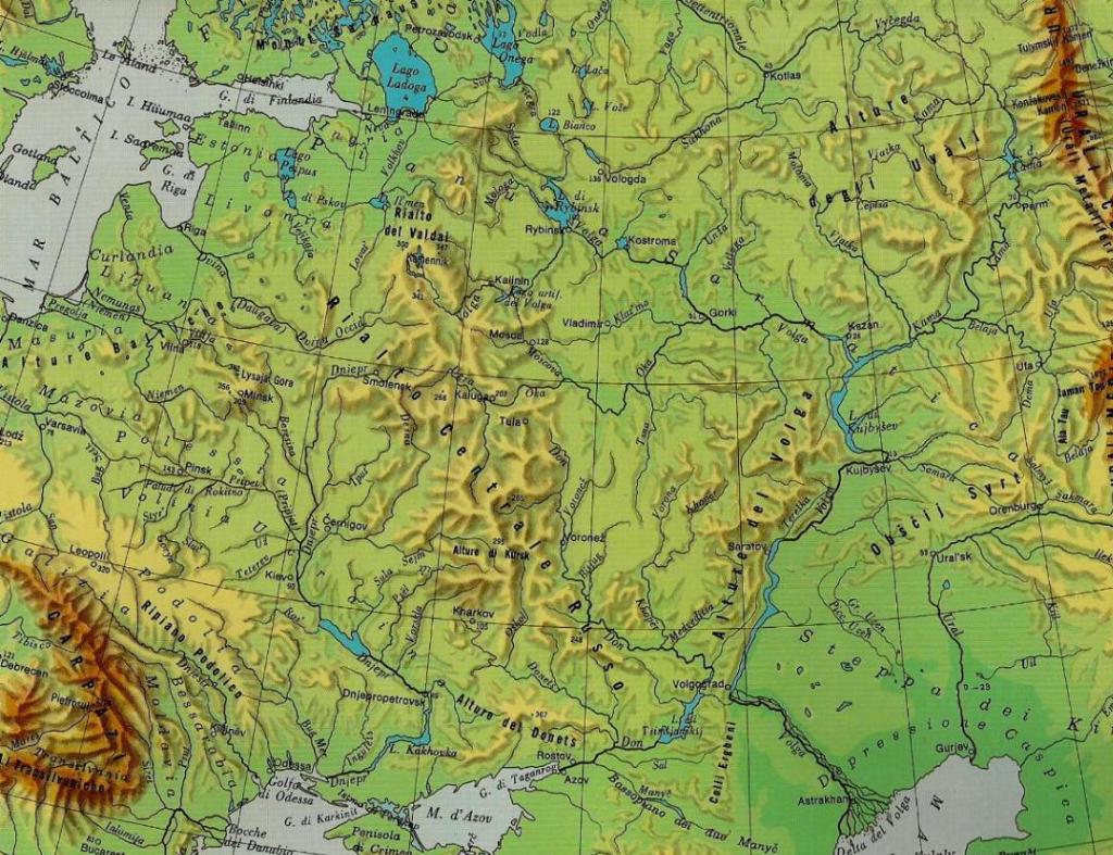
Operazione Barbarossa: ostacoli naturali
EUROPEAN RUSSIA: A NATURAL FORTRESS
No other European country can boast the size and number of natural obstacles
that protect even such a fraction of the Soviet realm. Any attack from the west
must hurdle those very obstacles, and, at the same time, overcome the military
resistance of the Soviets. In all that great expanse, only one major river, the
Pripyat, flows from west to east and appears to provide access to the interior.
But, of all the freaks of nature, just that river and its tributaries form such
a maze of swamps that the watershed of the Pripyat constitutes an obstacle
rather than a gateway to the interior of the USSR. Practically all other streams
and rivers of the Soviet Union flow from north to south, though a few flow in
the opposite direction. An attacker approaching from the west thus faces one
natural obstacle after the other. As one proceeds toward the east, those
obstacles become more and more formidable. The Dniestr, the Bug, the Neman, and
the Dvina conform reasonably well to the usual concept of natural obstacles in
the form of watercourses, although they are the very rivers that are peculiarly
treacherous. The watersheds of the Dnepr, the Don, and the Volga constitute
barriers of extreme difficulty. Moreover, the tributary streams of those
watersheds combine with the main rivers to form what amounts to a perfect
defense system. A look at the tributaries of the Dniestr on a 1:300,000 map, for
example, shows that no military architect could have laid them out to any better
advantage. In central and western Europe and on the Balkan Peninsula, not many
swamplands have been left in their primitive state. Western Russia, however,
still abounds in them. At one place or another, a high embankment may carry one
of the strategic railroads through these swamps (in most instances in an
unerringly straight line over every obstacle). Some stretches are crossed by a
hard-surfaced road, but aside from these few man-made structures the picture
remains as nature first painted it. Since the swamplands are part of the river
systems, they form a double obstacle. Natural obstacles like the Prip-yat area,
which blocks the approaches to central European Russia, and swamp and water
barriers like those formed by the Volkhov or the lower course of the Volga are
not to be found in central and western Europe. Then there are the Eussian
forests, most of which merge with the swamplands. Northern European Russia is a
woodland interspersed with swamps; the central part of European Russia abounds
in forests; the southern part of European Russia is practically devoid of woods.
As a matter of fact, European Russia is the only region of the Continent that
has arid steppes and sand flats of typical desert character. Northern European
Russia proper, that is to say the swampy woodland north and northeast of the
Valdai Hills, is not suitable for mobile warfare, particularly not for large
armored formations. The crucial blows of an offensive, therefore, have to fall
in central and southern European Russia. In central European Russia lies the
Smolensk-Moscow Ridge, a low glacial moraine whose western extension is known to
the Germans as the Orsha Corridor (Landbruecke von Orscha). This is the
watershed between the Black and Caspian Seas in the south, and the Baltic and
White Seas in the north. Here are the sources of the Dnepr, the Dvina, the Lovat,
and the Volga. Access to this ridge is of paramount importance for any conduct
of military operations in the western part of European Russia. But the western
approaches to the Orsha Corridor are protected by a wide belt of swamps and
forests which extends from the Pripyat Marshes past Velikiye Luki and up to
Leningrad. After breaking through this belt, an attacker still faces the
watersheds of the Don and the Volga. Even if he has reached the Volga, an enemy
coming from the west will find himself only in the outer ramparts of the Soviet
domain; before him lie the Ural Mountains, and beyond them, Siberia. (trad.
sotto)
http://www.allworldwars.com/Terrain-Factors-in-the-Russian-Campaign.html
La vetta più elevata della Bielorussia è rappresentata dal
Monte Dzierzhinsky che raggiunge i 345 metri slm. Minsk, capitale, è a 234 m slm. Tra Minsk e Varsavia
ci sono 500 Km e tra Minsk e Smolensk 300. Tra Smolensk e Mosca ci
sono 360 km. Varsavia dista da Stalingrado (Volgograd) in linea retta 1700 km.
L'attacco a Mosca si è pertanto sviluppato su una distanza di
oltre 1.000 km !!! in 3 mesi e mezzo.
Russia europea: una fortezza naturale
Nessun altro paese europeo può vantare le dimensioni e il numero di ostacoli
naturali che proteggono anche se localmente il territorio sovietico. Ogni
attacco da ovest deve superare questi ostacoli molto e, allo stesso tempo,
superare la resistenza militare dei sovietici. In tutto questo sistema un solo
grande fiume, il Pripyat, scorre da ovest verso est (ma anche la Dvina che
sfocia a Riga) mentre gli altri vanno da nord a sud o viceversa. Ma proprio quel
fiume e i suoi affluenti formano un labirinto di acquitrini che costituisce un
ostacolo piuttosto che una porta per l'interno dell'URSS. Chi malintenzionato si
avvicina da ovest se li trova davanti uno dopo l'altro. E più si va avanti e più
gli ostacoli aumentano e diventano grandi. Il Dniestr, il Bug, il Njemen, e la
Dvina sono fiumi e i bacini del Dnepr, del Don e del Volga costituiscono con i
loro affluenti (ragnatela di affluenti) un ulteriore ostacolo. Uno sguardo agli
affluenti del Dniestr su una mappa 1:300,000, per esempio, dimostra che nessun
architetto militare avrebbe fatto di meglio. Se al di fuori della Russia le
paludi sono state bonificate qui sono state lasciate allo stato primitivo. Solo
il passaggio di una ferrovia a volte modifica il paesaggio col suo terrapieno
dritto per diversi chilometri. Alcuni tratti sono attraversati da una strada
asfaltata, ma a parte queste poche strutture artificiali il quadro rimane come
natura lo ha fatto (le strade naturali diventavano acquitrini
con la Rasputiza, il micidiale fango russo stagionale (autunno e disgelo)). Poi ci sono le foreste russe, molte delle quali si fondono
con le paludi (dove regnerà la guerra partigiana). Come ci sono foreste al nord così ci sono steppe aride al sud in
Russia. La parte meridionale della Russia europea è praticamente priva di
boschi. Montagne (rilievi): I Valdai (cima maggiore m.347), non sono adatti ad
una guerra mobile, in particolare non per le grandi formazioni corazzate. Una
offensiva, di conseguenza, deve cadere nel centro e nel sud della Russia
europea. Nella Russia centrale (europea) si trova la cresta Smolensk-Mosca
(parte del rialto centrale russo anche qui cime modeste), residuo di una morena
glaciale la cui estensione occidentale è nota ai tedeschi come il Corridoio di Orsha (Landbruecke von Orscha). Questo è lo spartiacque tra il Mar Nero e il Mar
Caspio a sud, e il Mar Baltico e Bianco a nord. Qui ci sono le sorgenti del
Dniepr, Dvina, Lovat e Volga (qui pochi metri di dislivello segnano il destino
di un fiume che si alimenta non per le altezze dei monti ma per la alta piovosità e
le precipitazioni nevose invernali e se i fiumi sembrano toccarsi molto spesso è
una linea costituita da canali navigabili di collegamento). L'accesso a questo crinale è di
fondamentale importanza per qualsiasi condotta delle operazioni militari nella
parte occidentale della Russia europea. Ma l'approccio occidentale al Corridoio Orsha è protetto da una larga fascia di paludi e foreste che si estende dalle
paludi di Pripyat fino a Leningrado. ....
Torna all'indice
delle piantine