Earth is as ancient as the cartographic science, they think that an inhabitant of Asia
Small named Aristagora around the 500 a.c. has introduced a geographical paper drawn on
bronze tablets to the Spartanis and with that has incited them to the war against the
Persia of Dario I. Of the Cartography were founders Eratostene, that measured for first
the terrestrial ray and an arc of meridian and the messinese Dicearco 300
a.c., this last tried of to measure the dimensions of the Earth perhaps before Eratostene
(in the number of February 1998 of the National Geographic Magazine pagg. 8 and 9 there
are a photo of the well of Assuan where Eratostene is thought that it tried his/her theses
during the solstice in summer) .Dicearco divided the known space with a kind of grid
anticipating the meridians and the parallels; the word meridian derives from the Latin
" meridies ", two points that have the same time to midday are found on the same
meridian. Ipparco (190 - 125 a.cs.) that surely the biggest astronomer of the Greek
age, criticized the paper of Eratostene because of the lack of precise references and
determined the position of numerous places with measurements of longitude gotten after
repeated observations astronomiche. The beginning of the Roman conquests and the
relief of the busy territories to fiscal purpose brought to the big
cartographic work begun by Caesar and concluded from August (44 - 19 a.cs.). Marinus of
Tiro (110 d.c.) on the bases of the job of Ipparco introduced for first the
measure of the longitude and the latitude in degrees of arc rather than in stadi.Tolomeo,
lived between the 90 d.c. and 170 d.c. , conditioned from the work of Marinus of Tiro ,
invented the first Cartographic Projections ; he introduced two Projections
that although as conic were not considered such. In the Middle Ages the Cartography was
all to base of respects, the study and the search had buried inside the
monasteries, where only few monks could have entered. In this period they are the Arabs to
guard the tradition Tolemaica studying and redelivering to the West as beginning of
a new period of Cartographic rebirth. In the XIII century ; with the development use
of the compass a new cartography borns, that nautical, that uses the portolanis, maps
built with observations of angles and distances, maps that assumed an inestimable value.
In the XV and in the XVI century, also with the advent of the press and the marinate
enterprises , there was a cartographic revolution due to the enormous diffusion of the map
. The abandon of Mediterranean Sea , the extraordinary oceanic enterprises, the need
to know the position in sea, brought to the construction of the first geodetic tools. From
this moment in then the Projections are developed used today still and that we will
see following exposed with a trace of their more famous
Fig. A
Fig. B
2) The Shape of the Earth
The first humans believed that the earth around them was flat (there is
someone that believes today still that the Earth doesn't nearly have a spherical form).
The idea of the sphericity came to the philosophers of the era pre-Christian that they set
each other to reason on this problem; 500 years or more before the birth of Christ the
theory of the spherical Earth was formed. The sphericity of the Earth had generally
recognized from the second century A.D. If we remove the irregularities of the terrestrial
crust, the form of the Earth is been able approssimare to a sphere. The form assumed by
our planet, that wheel around its polar axis in the space, is the result of the
interaction of the centrifugal strength of rotation, of the strength of attraction
gravitational newtonian and of the variations of density of the rocks that constitute it.
The tectonics has produced irregularity of the terrestrial crust very light in comparison
to the equatorial ray; you are enough to think that on a world map of the ray of 25 cm.
the Everest mountain would be tall as soon as 0.032 cm.
3) The Geoid
The geoid is the shape that would assume the level of the sea undisturbed crossing the
continents. The geoid is a equipotenzial surface in which the tangent plan in every point
is perpendicular that is to the direction of the thread to lead in that point to the
vertical passing for that point. This surface has influenced from the variations of
density of the Earth and it is generally lifted above the continents to kneel on the
oceans. The irregularities of the geoid are equal to around 60 m. The geodesy has a
fundamental part in the determination of the precise shape of the Earth.
Fig. 1
4) The Spheroid
The spheroid is the geometric shaape of the Earth. The Earth is
squeezing to the poles. The difference between the equatorial and polar ray is equal to
around 21.5 km. and it depends on the Spherois that is considered. For precise
mapping of large areas, such as topographic mapping, a regular geometric figure must be
used. This is an ellipsoid of revolution, that is a figure produced by an ellipse rotated
around its minor axis.The Program Atlas.exe
downloadable from the site uses the Spheroid of Clarke 1866
that has the following parameters:
a = equatorial Ray = 6378206 m. s b = polar Ray = 6356584
m. 1/f = 294.98
If we consider the sphere of equal area-----> RSphere = 6370997 m.
f = (a-b)/a
In the underlying figure we have let coincide the vertical v with the
normal n,
really if the Spheroid is considered
it would be had to consider the normal , if it considers the Geoid
the vertical
fi
is the latitude of the point P lambda
is the longitude di P
Fig. 2
5) The Cartographic Projections
The alone true representation of the Earth free from distorsions is the globe. The
procedure through which has passed by the spherical surface of the Earth to a
bidimensional surface is called Projection.
This can be completed through direct geometric Projection or through the use of
mathematical formulas that modifying reads proiettive to them they arrive to you determine
conditions. Reports that tie a point on the map with a point on the Spheroid or on the
equivalent sphere are called Equations of the Map;
these can be directed or inverse. The shortest distance between 2 points is a straight
line; on the sphere it would be impossible to connect 2 points with a straight line to
have the shortest distance. On the earth the shortest distance between 2 points is the arc
that unites the 2 points gotten by the intersection of the sphere with the passing plan
for the 2 points and for the center of the earth (arc of great circle). This line is
always called Ortodromica and ransom the
meridians under different angles. Any great circle ransom the Earth in manner that for
half it is found in a hemisphere and for the other half in the opposite hemisphere. The
line that cuts the meridians under the same angle is called Lossodromica
the length of the Lossodromica is major than to the corresponding Ortodromica, however it
has the advantage to be the easiest run from to follow. Tracing a right line between two
points on a map of Mercatore we have the rout from to follow after the opportune
corrections to the declination of the compass.
6) Coordinate Systems
System of reference for Plain
Rectangular Coordinate
All the points have reported to a system of axes perpendicular among them
The intersection point of these axes is called Origin.
The position of any point on the plane with reference to the point of origin may then be
stated
by indicating the distance from each axis to the point, measured in each case parallel to
the other axis.
P(x,y)
x = distance of the point from the ordinate axis
y = distance of the point from the abscissas axis
System of reference forRectangular
Geodetic Coordinate
All the points have reported to a system in which the origin is always in
O. This time the position of a point P is defined by the abscissa, that
is her geodetic one for perpendicular P to the passing meridian forO (P
P') and from the ordinate that it is the arc of inclusive
meridian between O and the
point P' previously
described.
System
of reference for Plain
Polar Coordinate
All the points have reported to a system constituted by a point
P that is called pole and from a vertical semiasse that is directed toward the
tall (generally the Magnetic or Geographical North) from P. La position of a point S is defined through the distance of the point by the pole P and from the angle (azimuth (PS)) that the axis vertical form rotating in hourly sense up to be added to the
direction considered PS. S (PS,(PS)).System of reference forPolar Geodetic Coordinate
All the points have reported to a system constituted by a point
P that is called pole and from the passing meridian for P. La position of a point S is defined through the distance s = arc of geodetic
PS and from the angle (azimuth (PS)) that passing meridian for P forms rotating in hourly sense up to be added to the direction considered PS. S(PS,(PS)) System of reference forGeographical Ellissoidical Coordinate
The position of the points is individualized making reference to a system of lines in
which 2 are fixed of reference from there. The parallels are the lines gotten through the
intersection of parallel plans to the equator with the ellipsoid while the meridians are
being the lines of intersection of the arcs of maximum circle with the ellipsoid. The
lines of reference are the equator and the meridian in Greenwich. The position of a
punto
P is defined
through the Longitude (angle diedro that the
containing plan the meridian in Greenwich forms with the containing plan the meridian of
the punto P ) (lambda) and the Latitude
(angle that the normal to the ellipsoid passing per P forms with the equatorial plan ) ( fi )
Fig.2.
Equator = Place of the points with Latitude 0�.0000
Meridian = Place of the points with constant Longitude.
The situated points in the northern hemisphere have Latitude positive North from 0�.0000
to 90�.0000 (Pole North). The situated points in the southern hemisphere have Latitude
South from 0�.0000 to -90�.0000 (Pole South). The situated points to East of the
meridian in Greenwich they have values of Longitude from 0�.0000 to 180�.0000 while the
the meridian in Greenwich based situated points are having values of Longitude from
0�.0000 to -180�.0000.
7) Properties of the Projections
It's inevitable that there are errors of distorsion in the passage
from a spherical surface to a plain in every Projection. Every Projection distorts one ,
two , three and at times the whole following ownerships. Shape, Area, Distance and
Direction.
Conforming
Any map preserves the form of big areas, but a conforming
Projection maintains the forms in small and you locate areas . This Projection is
accompanied by the exact transformation of the angles around the points. Necessary
condition is that the parallels and the meridians are met perpendicularly as on the globe.
This ownership is exploited in the realization of the nautical papers. True-shape is often
defined even if the quality of the form has limited.
Equivalent
It shows the areas of all the zones on the map in the scale of
rappresentation . Preserv the areas means to transform in inaccurate manner the angles
around the points therefore exclusion of the ownership previously described. This
ownership is very important in the cadastral maps in which the revenue taxes the
ownerships in base to their surface.
Equidistant
Any map can represent the correct distance between 2 points, but
only from one or to the maximum one from 2 points to every other point. Usually the
equidistance is long the equator, along the meridian belonging to the center of Projection
or along one or two standard parallels or standard meridians.
Azimuthal
It shows the correct direction (azimuth) between two points; the line that unites
the two points ransom the meridians under the same angle " Lossodromic Line ".
However on a spherical surface the shortest distance between two points is a long great
circle which the azimuths constantly change. All the meridians are maximum circles while
the equator is being the only parallel that is a great circle.
8) Classification of the Projections
A method to classify the Projections is that to gather them in
the type of surface in which the graticule has been projected.
The principal Projections are:
Azimuthal
A plan is tangent to the globe, the point of contact it is the center
of Projection. If a source of light inside the globe projects the light on the plan, the
result it will be an azimuthal Projection. The choice of the Center of Projection
determines the aspect of the Projection. In the Polar Aspect
the center of Projection is the pole, in the Equatorial
Aspect the center of Projection is a point on the equator, in the Oblique Aspect the center of Projection is an any
other point.
The principal Azimuthal Projections are:
Azimuthal Equidistant : It's probablethat this Projection has been used for the first
oneby the Egyptians for the representation
of the stellar maps. This Projection is not neither conforming neither equivalent. The
parallels are generally complex curves, only in the polar aspect they are circles. The
equator is a right line in the equatorial aspect, the greatest part of the meridians they
are curved complex, they make exception the meridians in the polar aspect and the central
meridian that are right lines. The distances measured by the center of Projection are
true; the distances that are not measured along the rays from the center are not correct.
The only point without distorsions is the center of Projection. With this Projection it is
possible to represent all the Earth. The pole of the center of Projection is a point,
while the other pole is being a circle with double ray of that equatorial.
Gnomonica : The point of view V is in the center of the globe O, all the meridians and the equator are right lines, all the parallels except,
the equator and the poles are, ellipsis, parables or exaggeration. This Projection is not
neither conforming neither equivalent, less than a hemisphere can be seen. Only to the
center of Projection C there
are not distorsions, the distorsions increase as that it gets further there from the
center of Projection.
Stereografica :Il point of view V and from the opposite part to the center
of Projection C . It 's used
for representing the zones nearby the polar regions . The Projection is conforming . All
the meridians in the polar vision and the equator in the equatorial vision are straight
lines. All the other meridians and parallels are arcs of circle. The directions from the
center of Projection are true ( except on that oblique ellipsoidal and equatorial ). The
scale increases as that it gets further there from the center of Projection.
Orthographic : The point of view is to the infinity V, it is visible only a hemisphere. The
Projection is not neither conforming neither equivalent. The greatest distorsions are to
the edges of the hemisphere. Any distorsion next to the center of Projection C . The directions from the center are true. The
factor of radial scale decreases to increase some distance from the center to him.
Fig.6
Azimuthal Equivalent of Lambert : This Projection
was introduced by Johann Heinrich Lambert in 1772. It's also known as Equivalent
Zenith Projection. The Projection of the not perspective azimuthal type is equivalent.
Only the center of Projection is free from distorsions, but the distorsions have moderated
in an area of 90� around this point. The scale is true only in the center of Projection,
it increases in tangential manner and it decreases radially from the center of Projection.
The Projection is not neither conforming neither equidistante.With this Projection it's
possible to see the whole globe. You frequently use in the representation of the polar
regions.
Johann Heinrich Lambert (1728-1777) it was born
26/08/1728 in Alsazia today's Switzerland. It was done alone, considering that it
abandoned the school to the 12 year-old age to help his father that was a tailor. During
this period he read books of mathematics, astronomy and physics exclusively, but he didn't
return to school anymore. To the 20 year-old age it was already master of those
disciplines from him you prefer and he/she spoke 5 languages fluently (German, French,
Italian, Latin, and Greek) .Nel 1761 he became a member of the academy of Fredrick the
Greatto Berlin. It began to work for him in
1764. After one year Fredrick put him in the Directive Committee of the Academy next to
two famous mathematical as Leonhard Euler and Joseph-Louis Lagrange. While it was being to
the service of Fredrick Lambert it showed that the constant � was irrational and
developed the hyperbolic function in trigonometry. during this period was created the
Cartographic Projections her most famous of which (Lambert Conformal Conic) was used for
the representation of Russia and the Mediterranean. Johann Heinrich Lambert died of
respiratory illness 25/09/1777. Although many remembers him for his Projections it was
more than a cartographer considering that it devoted the greatest part of his life tostudy about parallel disciplines.
Cylindrical
The graticule is projected on a cylinder ; the Projection has directed if
the cylinder is tangent to the equator, it's inverse if it's tangent to a meridian, it's
secant if it's tangent to a different parallel from the equator, it's oblique if the
directrixes of the cylinder are not perpendicular or parallel to the polar axis . The
point of view is in the center of the globe. Meridians and parallels are right lines. In
this Projection the expansions increases as that it gets further there from the
equator; really for this the Projection is used for representing the zones around the
equator.
Fig.7
The principal Cylindrical Projections are:
Miller : Osborn Maitland MIller introduced this Projection in 1942.
The cylinder is tangent to the sphere along the equator. This Projection has meridians and
right parallels, perpendicular therefore among them, but the right lines don't have
constant azimuth. The length of the meridians is equal to 0.73 times around that of the
equator. The parallels have spaced otherwise, the distance among them increases toward the
poles, however this distance is always small of that of the direct Projection of
Mercatore; in this manner the poles can be represented. The Projection of Miller is not
neither equivalent neither equidistant, neither conforming neither perspective. The scale
is true only along the equator. The distorsions become unacceptable to the poles. This
Projection avoids the exaggerations of scale of the Projection of Mercatore.
Mercatore : Drawn by Gerardo Mercatore in the 1569 ,
this Projection has meridians and right parallels , the scale is true along the parallel
of tangency. This Projection is used for the navigation in how much all the right lines on
the map have constant azimuth. To preserve the Conformality of the map the parallels
increased the distance from the equator. because of the big deformations it has rarely
extended over 80�.0000 of latitude North or South.
Fig.8
Fig. D
Gerardo Mercatore (1512-1594) it was born to
Rupelmunde in the Flanders (Belgium) 05/03/1512 his name was Gerhard de Kramer. He devoted
his life to the Cartography although was also scientist and extraordinary engraver. Child
of a cobbler frequented the university of Louvain where he studied philosophy and
humanism. He was graduated in 1532 and he immediately was embarked for looking for the
tests of the word of the Bible in antithesis with the opinions of Aristotle. It didn't
reach to any conclusion, it acquired the passion instead for the Geography. In 1535 a
laboratory of cartography opened and in 1537 it realized hist map an equivalent Projection
of Palestine. The Projection of Mercatore of the world had realized in 1538 and for that
time it was a big conquest. It was approached to the tied up problems to the navigation
creating a Projection where the right lines compensate the variations and the magnetic
deviations. These lines are known as lossodromic . In 1540 it realized
and a map of the Flanders to which paid attention the Cardinal of Grandeville engraved
(Charles' IV Primo Ministro) that the realization of a world map commissioned him for the
Emperor that realized in 1541. In 1544 it escaped for miracle from the death when was
imprisoned for 7 months with the accusation of heresy from the Regina of Hungary that was
contrary to the Protestant reform. The greatest part of the men and the women considered
to be heretical Lutheran had put to death. Mercatore abandoned religious ideas as
soon as he was released. In the 1552 was named Cosmografo from Charles V. In the years
following Mercatore realized numerous maps, a lot of of which were not published never. In
1594 he died to Antwerp a city of the Flanders. Although many his jobs are gone forgotten
or lost, his Projection more famous it is still the standard for the navigation.
Oblique Mercators Hotine To and B : Oblique
Projection. It was used to the beginning for cartograf the regions that had an oblique
development in comparison to the meridians and to the parallels, then it was used before
the Space Oblique Mercator for mapping the Landsats. The Projection is conforming. The
parallels are curved complex. The meridians are curved complex except the two meridians
that are to the sides that are right lines. The scale extends to the endless one to
90�.0000 from the central line. The Hotine A uses 2 points that belong to the central
line, the first point fixes the point of contact while the second is giving the direction.
The Hotine B uses a central point of contact and an Azimuth to give the rotation to the
cylinder of tangency; Azimuth = 0�.0000 crossbeam cylindrical Projection; Azimuth =
90�.00000 direct cylindrical Projection. The distances are true along the maximum circle
of tangency.
Fig.9
Cassini : This projection is the transverse aspect of the
Plate Carr�e projection, developed by C�sar Fran�ois Cassini de Thury (1714-84). It is
still used for the topographic mapping of a few countries. Central Meridian is a straight
line (includes meridian opposite the central meridian in one continuous line). Other
Meridians are straight lines if 90� from central meridian, complex curves concave toward
the central meridian otherwise. Parallels are complex curves concave toward the nearest
pole. Poles are points along the central meridian. Symmetry is about
any straight meridian or the Equator. This is a projection onto a cylinder tangent at the
central meridian. Distortion of both shape and area are functions of distance from the
central meridian. Scale is true along the central meridian and along any straight line
perpendicular to the central meridian (i.e., it is equidistant). For
cylindrical projections, only one standard parallel is specified. The other standard
parallel is the same latitude with the opposite sign. For this projection, the standard
parallel of the base projection is by definition fixed at 0�.
Equirectangular : Equivalent Projection. In the
classical version the meridians are straight lines equally spaced , while the
parallels are being straight lines otherwise spaced more you bring closer to the poles
that cut the meridians with the correct angle. The scale is true along the equator or long
2 equidistant parallels from the equator. In the trasverse version, the central meridian
and the equator are straight lines, while the other parallels and meridians are being
curved complex.
U.T.M. : The Universal Trasverse Mercator Projection
divides the world in the ample vertical zones 6� and ample horizontal bands 8�. The
Projection has its center in the central meridian of the considered zone . The zones are
extended by 80� Latitude South to 84� Latitude North. The conventional abscissa of the
central meridian has generally fixed in 500 km, for the hemisphere North the ordinate has
fixed to 0.00 km while for the hemisphere South the ordinate has fixed to 10000 km
Fig.10
PseudoCilindrical
The Projection PseudoCilindrical recalls the Cylindrical Projections
but in this case while the parallels are being right the meridians they are curved.
The principal Projections Pseudocilindrical are:
Robinson : This Projection was introduced by Arthur
H. Robinson in 1963 and has also called The Orthophanic Projection , that
means right appearing. The central meridian is a line right long 0.51 times the equator,
while the other meridians are resembling to arcs concave elliptical toward the central
meridian. The parallels are perpendicular right lines to the central meridian; they have
spaced equally up to 38� of latitude, over this limit the distances decrease. The poles
are lines long 0.53 times the equator.The
scale is true solo along the 38� parallel and is constant along any parallel or between
every couple of equidistant parallels from the equator. The distorsions have limited
within 45� from the center and along the equator. This Projection is not equivalent,
neither conforming, neither equidistant, it is therefore a Projection that extends to have
contained deformations. It is a good Projection for the representation of the world. Was
the Rand McNally Publishing Company that commissioned to Robinson its
realization. It's surely the better Projection for the representation of the world as
dimension and form. In the 1988 the National Geographic Society replaced
the Projection with which had represented the world for 65 years with the Projection of
Robinson.The characteristic of this
Projection is the use of charts of coordinates rather than mathematical formulas of
Projection of the graticule
Fig. E
Mollweide : This equivalent Projection (introduced
by Karl Mollweide in 1805)is used for the
representation of the world. The central meridian is right and perpendicular to the
equator. The first one is half the second. The 90th meridians are arcs of circle while the
other is being arcs of ellipsis that connect the two poles. The parallels are right but
otherwise spaced. The scale is true only along the parallels 40�44 's N and 40�44 's S.
Karl Brandan Mollweide (1774-1825) it was born
03/02/1774 to Lipsia. After a precocious infancy it was graduated to the University of
Halle and it was teacher to the Franckesche Stiftung. During this period it created his
Projection. In 1811 Stiftung left for the University of astronomy of Lipsia where teacher
was named head and he occupied the desk of mathematics. It was an authority for the
mathematical sciences and it developed trigonometry.
Sinusoidal : This Projection had developed in the sixteenth century
and used by Cassini in 1570 and from Jodocus Hondius in the atlas of Mercatore before the
seventeenth century. It's currently the oldest Projection pseudocilindrical in use, it
takes the name of Sanson-Flamsteed or Equivalent Projection of Mercatore. it's an
equivalent Projection with right parallels equally spaced they intersect the central
meridian, long half the equator, with the correct angle (parallel perpendicular to the
central meridian), the other meridians are curved sinusoidalis equally spaced that they
are met to the poles; they are concave toward the central meridian. The poles are points.
The Projection is symmetrical in comparison to the central meridian and to the equator.
The scale is true only on the central meridian and the parallels, the distorsions they
begin to increase next to the external meridians to the tall latitudes. This Projection
has a fictitious because fixed standard parallel to the latitude of 0�.0000. Often used
for the representation of states with vertical rather than horizontal development (Chile).
Projection used since half the sixteenth century
Wagner IV : This Projection had introduced from Karlheinz Wagner in
1932. The central meridian is long half the equator. The other meridians are parts of
ellipsis, concave toward the central meridian, equally you space. The meridians with
longitude 103�55 ' East and West are arcs of circle. The parallels are right lines
otherwise spaced perpendicular to the central meridian. The distance between the parallels
increases approaching each other to the equator. The poles are lines long half the
equator. You Projection is equivalent. The scale is true solo along the parallel 42�59 '
and it is constant along any parallel and between every couple of equidistant parallels
from the equator. You distorsions are not so extreme toward the external meridians to the
tall latitudes, but there are a considerable distorsion of the polar regions. The
distorsions are annulled in the two points where the parallels 42�59 ' they meet the
central meridian. This Projection is not neither conforming neither equidistant.
Conic
In a Conic Projection the grid is projected on a tangent or secant cone to the globe
along a small circle (usually a parallel of middle latitude in comparison to the zone from
to represent). In the normal version the parallels are projected to form arcs of circle,
while the meridians are being projected as right lines that are radiated to intervals
uniforms of angle from the apex of the flattened cone. The conic Projections are not very
you use in the maps. The secant case that produces two standard parallels is used more
frequently with the conic Projections. The scale of the map distorts the distances quickly
for all the points that I am estranged by the standard parallels. Because of this problem
the conic Projections are used for representing zones that are developed along the
parallels, the United States of America they are frequently represented with conic
Projections.
Fig.11
Fig.12
The principal Conic Projections are:
Albers : This Projection had introduced from
Heinrich Christian Albers in 1805.it is an
equivalent Projection that distorts scale and distance except along the standard
parallels, the scale is constant along any parallel. The parallels are arcs of circle
concentric otherwise spaced, the space between the parallels decreases as that we estrange
from the central latitudes. The meridians are rays of the same circle equally spaced, they
cut the parallels with the correct angle, the angle between the meridians it is small of
that true. The poles are arcs of circle. This Projection is used for representing regions
that are developed long east-west ( United States of America ). For the Projection of the
United States the standard parallels of 29�30'00" and 45�30'00" are used. You
Projection is not neither conforming neither equidistant. The classical parallels are 15�
and 75�
Bonne : This projection dates in
a rudimentary form back to Claudius Ptolemy (about A.D. 100). It was further developed by
Bernardus Sylvanus in 1511. It derives its name from its considerable use by Rigobert
Bonne, especially in 1752. The Central Meridian is a straight line. Meridians
are complex curves connecting points equally spaced along each parallel and concave toward
the Central Meridian. Parallels are concentric circular arcs spaced at true distances
along the central meridian. Poles are points. The symmetry is about the Central
Meridian.This is an equal-area projection. The curvature of the standard parallel is
identical to that on a cone tangent at that latitude. The central meridian and the central
parallel are free of distortion. This projection is not conformal.This
projection has one standard parallel, which is 30� N by default. It has two interesting
limiting forms. If a pole is employed as the standard parallel, a Werner projection
results; if the Equator is used, a Sinusoidal projection results.
Lambert Conformal Conic : This Projection was
introduced by Johann Heinrich Lambert in 1772, is known also as the Projection Conic
Ortomorfic. It's a conforming Projection that distorts the area and the form as that we
estrange from the standard parallels, the distorsions are constant along any other
parallel . The scaleis constant along any
parallel and it is her same one in every direction toward point any. The parallels are
concentric arcs of circle otherwise spaced, more brought closer next to the center of the
Projection. The meridians are rays of the same circle equally spaced, that cut the
parallels with the correct angle, the angle between the meridians it is small of that
real. For the Projection of the United States the standard parallels of 33�00'00"
and 45�00'00" are used. The Projection is not neither equivalent neither
equidistant.
Policonic : Developed in 1820 from Ferdinando
Hassler, this Projection has founded on an endless number of tangent cones to an endless
number of parallels . The central meridian is right while the other meridians are being
curved complex. The parallels are arcs of circle non concentric. All the meridians are
concave toward the central meridian. The parallels cut the central meridian to equal
intervals, these intervals they increase as that we estrange from the central meridian.
The scale is true solo along every parallel and solo along the central meridian.
The modified Projections are all those Projections that don't revert
completely in one of the cases previously examined.
Hammer : This Projection had introduced from H. H.
Ernst von Hammer in 1892. This Projection is equivalent, the only point free from
distorsions is the center of Projection. It has less angular distorsions in the most
external meridians next to the poles, in comparison to the Projections pseudocilindrical .
The central meridian is a line right long half the equator; the other meridians are curved
complex equally you space along the equator and concave toward the central meridian. The
equator is right, while the other parallels are being curved complex equally you space
along the central and concave meridian toward the nearest pole. This Projection is an
equivalent Projection to edge ellittical. It's a change of the Azimuthal Projection of
Lambert inspired by the Projection of Aitoff.
General Vertical Near/Side Perspective : This
Projection ( known from the Greek and from
the Egyptians around 2000 years ago ) it's a Projection of the type Perspective Azimuthal
Scenografich, only that the point of view V is not from the opposite part
of the center of Projection C , but from the same part. The Projections
previously azimuthal sights are of the particular perspective Projections. The distance
between the point of view V and the center of Projection C
is the height of the point of view above of the surface terrestrial HAboveS.
it is often used for showing the planet as seen by the space. The meridian and the
parallel of the center of Projection are straight lines. The other meridians and parallels
are arcs of circle and ellipsis, but you/they can be also parables and exaggeration. The
Projection is not neither conforming neither equivalent. The greatest distorsions are to
the limits of the zone of Projection.
Fig.13
Van der Grinten : This Projection had introduced
from Alphons J. Van der Grinten in 1898. it is a Projection that can have classified as
policonic. The central meridian is a right line while the other meridians are being arcs
of circle spaced equally along the equator and concave toward the central meridian. The
equator is a right line, while the other parallels are being arcs of circle concave toward
the nearest pole. The Projection is not neither conforming neither equivalent. The world
is contained in a circle. The scale is true solo along the equator and increases quickly
as that we get further of it. The distorsion of area they are extreme next to the poles.
Interrupted
The interrupted Projections are used for representing the world and
to minimize the distorsions.
Goode's Homolosine : J.P.Goode studied this
Projection composite Pseudocilindrical of the Equivalent type (Equal Area). The parallels
are perpendicular parallel and right lines to the central meridians. They have spaced
equally between the latitudes 40� 44' N and S. Per great values of latitude the parallels
extend to draw near hand to hand that the poles are approached. Between the latitudes 40�
44 ' N and S, the meridians are curved sinusoidalis equally you space, otherwise they are
arcs ellittici, concave toward the central meridian. The meridians have turned slightly
toward the suitable latitudes. The six central meridians are right lines that have a value
0.22 times that of the equator. The northern hemisphere has two central meridians to
-100� and 30� degrees of longitude. The southern hemispherehas the central meridians to the longitude of
-160�, -60�, 20� and 140� degrees. The center of the map is to 0� degrees of
longitude and 0� degrees of latitude. In the northern hemisphere, the interruption is set
to-40� degrees of longitude. In the southern
hemisphere the interruptions are mails to -100�, -20� and 80� degrees of longitude. The
meridian -180� degrees it represents the edge of the Projection. Between the given
latitudes, the scale is true along every latitude and along the central meridian. Over
these latitudes, the scale is identical for the latitude of opposite sign. The Poles are
points.
Mollweide : It's a Projection Pseudocilindrical of
the Equivalent type (Equal Area). The Parallels are right lines otherwise spaced more
outdistanced near the equator and perpendicular to the central meridian. The Meridians are
arcs spaced semielliptical equally that they are intersected to the poles and they turn
concavity toward the central meridian. There are six central meridians that are right
lines from the poles to the Equator. The northern hemisphere has the central meridians to
the longitudes of 60�, -170� and -30� degrees. The southern hemisphere has the central
meridians to the longitudes of 90�, -140� and -20� degrees. The center of the map is
set to the longitude -160� and to the latitude 0� degrees.In the northern hemisphere the interruptions are
mails to the meridians 110� and -100� degrees. In the southern hemisphere the
interruptions are mails to the meridians 140� and -70� degrees. The meridian 20�
degrees it represents the edges of the Projection. The scale is true along the latitudes
40� degs 44 ' min N and S and it is constant along any gives latitude. It is her same one
for the latitude of opposite sign. The Poles are points. The central meridians and the
equator are elements of symmetry.
References
Map Projection Overview / Peter H. Dana Department of Geography
The University of Texas at Austin.
"Map Projections - A Working Manual" by John P. Snyder
U.S. Geological Survey Professional Paper 1395
United States Government Printing Office, Washington: 1987
Aviation Formulary V1.19 by Ed
William - Modified for East + and West -
WOLFRAM - RESEARCH
- Eric Weisstein's world of MATHEMATICS -
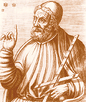 Fig. A
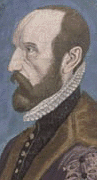 Fig. B
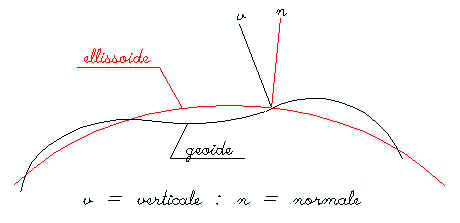 Fig. 1
 Fig. 2
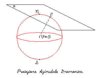 Fig.3
Fig.3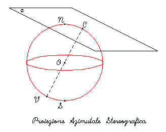 Fig.4
Fig.4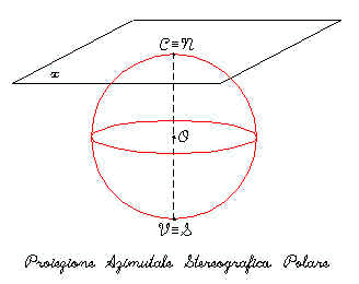 Fig.5
Fig.5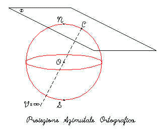 Fig.6
Fig.6 Fig. C
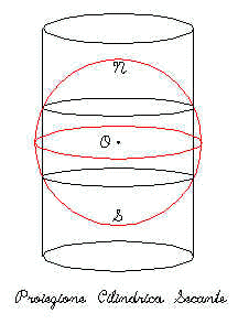 Fig.7
Fig.7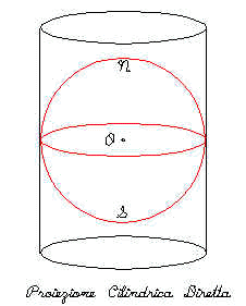 Fig.8
Fig.8 Fig. D
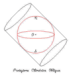 Fig.9
Fig.9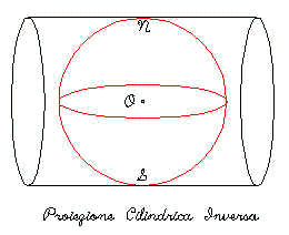 Fig.10
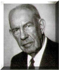 Fig. E
 Fig.11
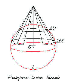 Fig.12
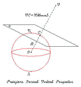 Fig.13