|
It is now uniformly agreed that the
crustal plates
of the Earth are in horizontal motion. This is called continental
drift colloquially, and
plate tectonics
(see also
this summary)
in technically more precise language. This is newly won knowledge.
Although the idea has been around for almost a century, it was not generally
accepted (indeed, was often considered crackpot) until the last few decades.
The following animation illustrates the drift of the continental plates over
the last 750 million years
(Source).
Here is a
better animation
(but it is a 1.44 MB animated GIF file).
 |
 |
| Animation of
the drift of the continental plates over the last 750 million years. Click
the "stop" button on your browser to stop the animation at a particular
time. Restart the animation by hitting the "reload" button on your
browser. Click on the geologic time periods on the right for more
information on those periods. |
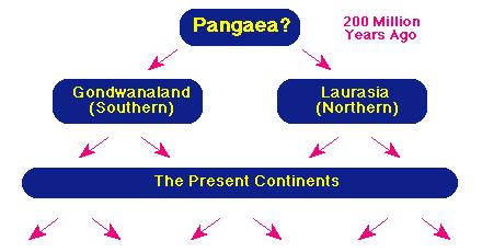
The Drift of the Continents
We now believe that the surface of the Earth
looked very different 200 million years ago from its present appearance. In
particular, the continents have changed because they sit on blocks of the
lithosphere that are in horizontal motion with respect to each other, and indeed
they continue to change because the horizontal motion continues. The following figure illustrates.
 |
|
The separation of the continents by plate tectonics |
The present continents separated from two supercontinents called Laurasia and
Gondwanaland through this process of plate tectonics. The two supercontinents
may have once been united in a single supercontinent called Pangaea, though this is less certain.
The Origin of Plate Tectonics
What is the origin of plate tectonics? The
continents drift slowly (the timescale for substantial change is 10-100 million
years), but that they drift at all is remarkable. The following figure
illustrates the structure of the first 100-200 kilometers of the Earth's
interior, and provides an answer to this question.
 |
|
The lithosphere and the aesthenosphere |
The crust is thin, varying from a few tens of kilometers thick beneath the
continents to to less than 10 km thick beneath the many of the oceans. The crust
and upper mantle together constitute the lithosphere, which is typically 50-100
km thick and is broken into large plates (not illustrated). These plates sit on the aesthenosphere.
The aesthenosphere is kept plastic (deformable) largely through heat
generated by radioactive decay. The material that is decaying is primarily
radioactive isotopes of light elements like aluminum and magnesium. This heat
source is small on an absolute scale (the corresponding heat flow at the surface
out of the Earth is only about 1/6000 of the Solar energy falling on the
surface). Nevertheless, because of the insulating properties of the Earth's
rocks this is sufficient to keep the aesthenosphere plastic in consistency.
Convection Currents
Very slow convection currents flow in this plastic
layer, and these currents provide horizontal forces on the plates of the
lithosphere much as convection in a pan of boiling water causes a piece of cork
on the surface of the water to be pushed sideways (following figure).
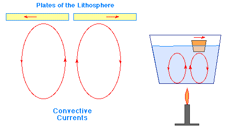 |
|
The plates of the lithosphere and convection in the aesthenosphere |
Of course, the timescale for convection in the pan is seconds and for plate
tectonics is 10-100 million years, but the principles are similar. Thus, we see
that differentiation is crucial to plate tectonics on the Earth, because it is
responsible for producing an interior that can support tectonic motion.
Evidence for Plate Tectonics
The original conjectures concerning plate tectonics were based on
circumstantial evidence like the shapes of continents being such that they would
fit well if pushed together. Today, we have a much broader set of evidence in favor of the hypothesis.
Indications of Tectonic Activity
Among the classes of evidence for continental drift and the underlying plate tectonics we may list
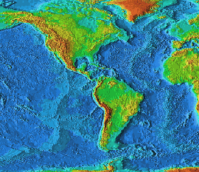
- The shapes of many continents are such that they look like they are
separated pieces of a jig-saw puzzle. For example, look in the adjacent map at
the shape of the east coast of North and South Americal relative to the shape
of the west coast of Africa and Europe.
- Many fossil comparisons along the edges of continents that look like they
fit together suggest species similarities that would only make sense if the
two continents were joined at some point in the past.
- There is a large amount of seismic, volcanic, and geothermal activity
along the conjectured plate boundaries. This is shown clearly below in the
figure labeled "Crustal plate boundaries" where the epicenters of earthquakes
above
Richter magnitude
5.0 are plotted for a 10-year period. The concentration is
striking, and indeed this plot serves to define the plate boundaries extremely
well. Here is a
clickable map
of current volcanic activity on Earth.
- There are ridges, such as the Mid-Atlantic Ridge (see figures above and
below) where plates are separating that are produced by lava welling up from
between the plates as they pull apart. Likewise, there are mountain ranges
being formed where plates are pushing against each other (e.g., the Himalayas,
which are still growing).
Plate tectonic motion, which may be only
centimeters per century, is now being studied by careful laser ranging
techniques that are capable of detecting such small motions.
Age of the Sea Floor
If the crustal plates are pulling apart at boundaries like the Mid-Atlantic Ridge (see the line of earthquake epicenters
down the center of the Atlantic in the preceding figure), the sea floor near
these ridges should be very young geologically, since it is formed of material
upwelling from the interior. This is indeed the case, as the following figure shows.
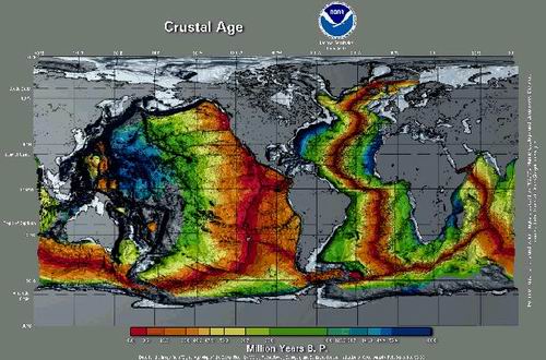 |
| Age
of the sea floor crustal plates |
This figure displays the estimated age of sea floor crustal plates with red the youngest and blue the oldest
(more information).
Click on the image for a larger one with legible writing (but
it is a 385 kB file). One can see clearly that material near the crustal boundaries is very young geologically.
Consequences of Plate Tectonics
Past and future consequences of plate tectonics for the Earth's surface are enormous.
Some Past and Present Consequences
Plate tectonics has been responsible
for many of the features that we find on the surface of the Earth today. A few examples include
- The Appalachian Mountains were formed from wrinkling of the Earth's
surface produced by the collision of the North American and African plates.
- The seismic and volcanic activity of the West Coast of the United States
(for example, the
San Andreas Fault)
is produced by the grinding of the Pacific and North
American Plates against each other. Indeed, the entire "ring of fire" around
the Pacific, corresponding to regions of high volcanic and seismic activity,
is caused primarly by the motion of the Pacific Plate.
- The Dead Sea in Israel is part of a rift system produced by plates that
are pulling apart in that region.
- The Himalayan Mountains were formed (indeed are still growing) as a result
of the Indian subplate burrowing under the Eurasian plate and raising its
edge.
Here are links to
animations
of the motion of continental plates for the last 750 million years.
Some Future Consequences of Plate Tectonics
Plate tectonics is still an active process, and will drastically reshape the face of the Earth over the next
50 million years or so. A few consequences of plate tectonics based on
projections of present motion include:
- Portions of California will separate from the rest of North America.
- The Italian "boot" will disappear.
- Australia will become linked to Asia.
- Africa will separate from the Near East.
As a consequence of plate tectonics (supplemented by wind and water erosion), we live on the surface of a
geologically active planet that has obliterated most of its early geological history.
| 


)
)
)
)