Figure 1 Figure 2
THE CLIMATIC RISK FOR THE CIRCUMMEDITERRANEAN AREA
Franco Ortolani (1); Silvana Pagliuca (2); Valerio Buonomo(1)
(1) Dipartimento di Pianificazione e Scienza del Territorio, Università di Napoli Federico II, Napoli, Italy; fortolan@unina.it
(2) ISAFOM, CNR, via Cupa Patacca, Ercolano, Napoli, Italy; pagliuca@ispaim.na.cnr.it
KEY WARDS: climate change, geological risk, Circummediterranean Area
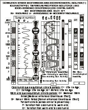
Geoarchaeological studies carried out in the Circummediterranean Area evidence that, during the last thousands years, the beginning of each millennium has been characterized by rapid and severe change of climatic-environmental conditions, according to a millennial cyclicity. Correlation of the geoarchaeological stratigraphy with the reconstruction of multicentennial solar activity shows that significant and cyclical environmental changes occurred in the Mediterranean Area in concomitance with significant multicentennial changes in solar activity (figure 1). During the periods in which the temperature increased by 1-2° C the coastal zones were affected by desertification up to a latitude of about 42°.
The acme of these changes was recorded during warmer periods of 100-200 years connected to a northwards shift of present day environmental conditions.
We defined these climatic variations, similar to those expected in the near future (“Enhanced Greenhouse Effect of the third millennium”) and connected to the Greenhouse Effect increase, “Enhanced Roman Greenhouse Effect” (100-300 A.D.) and “Crusades Greenhouse Effect” 1100-1270 A.D..
The palaeoenvironmental reconstructions evidence that during the past warmer periods all the Circummediterranean Area was affected by severe physical modifications due to the variation of geomorphological equilibrium, pedogenetic processes, water availability, river discharge, cultivated areas.
On the base of the results acquired with the geoarchaeological researches and evaluating the present day cities localization it is possible predict that many urban areas will be affected by severe modifications of the stable geoenvironmental conditions that have favoured the development of the anthropised areas, until present day. The predictable climatic risk that will affect the cities in the near future, during the climatic transition period, will be different according to the latitude.
The Mediterranean cities will be interested by:
- significant decrease of fresh water availability;
- increase of groundwater and river pollution;
- severe beach erosion;
- slopes geomorphological instability.
The shift of Mediterranean climatic conditions a few degrees to the north will cause an appreciable variation in rainfall in central-northern Europe and will cause a seasonalisation of rainfall with consequent periods of concentrated bankful flows which will be far greater than current levels.
Given that the urbanisation of river valleys has up to now occurred in relation to the hydrological river regime, hence without alternating periods of marked lows and highs, it is forecast that river valleys will be affected by repeated catastrophic flooding that will result in serious damage to the consolidated socio-economic organisation of the cities (figure 1).
On the basis of scientific data acquired, it is possible to predict climatic and environmental changes expected in the next 100 years.
A- The most serious environmental changes are expected in coastal areas where a sharp reduction in rainfall and a marked temperature rise are expected, such as to cause climatic desertification (annual rainfall about 200-250 mm). According to the three-dimensional relationships, the alluvial aquifers in these belts may be naturally fed only by vertical rainfall (e.g. the northern and southern parts of the Sele river plain, the Alento and Bussento plains) or also by feeding from neighbouring limestone aquifers (e.g. the Campanian Plain and Agro Nocerino-Sarnese). The most serious water crisis may be forecast on those plains that do not benefit from the feeding of groundwater from confining limestone aquifers; the sharp reduction in water feeding into coastal aquifers will cause greater salt water intrusion into depressed retrodunal plains with a resulting crisis for agriculture.
In Southern Italy considerable problems for irrigation, industrial and domestic uses will arise from the serious reduction in renewable water resources that will affect the limestone aquifers (over 50% less). Indeed, not only is the drinking water requirement but also industrial and irrigation requirements are based on spring water and on water extracted from alluvial aquifers.
On the basis of the knowledge acquired on soil surface changes and short-term trends in water resources, it is possible to outline the main problems that will affect agriculture in relation to geographical position, morphology and the three-dimensional geological regime. The most significant expected environmental variations will occur on the eastern Southern Apennine belt, consisting of a chiefly clayey substrate, in which durum wheat cultivation is chiefly concentrated, representing a staple for pasta production which is known to play an important role in the Italian economy. From the predicted change in rainfall in the near future it is clear that in most of this area farmland there will no longer be the soil moisture needed throughout the durum wheat vegetative cycle.
During the past warm periods the littorals with silicoclastic sands where affected by severe erosion while the beaches with bioclastic sands where characterised by evident progradation. During the decreases in temperature the areas of the alluvial plains subject to human impact and settlements were affected by an accumulation of huge volumes of sediments with consequent aggradation and progradation of the coastlines in the northern part of the Mediterranean while severe erosion occurred along the beaches with bioclastic sands of the southern part (Archaic Little Ice Age, 500-300 B.C.; Dark Age Little Ice Age, 500-750 A.D.; Little Ice Age, 1500-1830 A.D.) (figure 1).
On the basis of scientific data it is possible to predict that the beach erosion, prevalently caused by the climate variation, will continue for 150 years at least. Many thousands of kilometres of the Mediterranean coastline are affected by serious erosion which undermines not only the aggressive anthropisation that has taken place up to a few metres from the sea, but also the social and economic structure of entire regions whose economy is largely based on seaside tourism. It is undeniable, in fact, that coastline economy based on quality tourism, fostered by beautiful beaches, has made a considerable contribution to the improvement of the social and economic position of the coastal regions. The beach erosion, consequently, represent a direct economic danger for the national and regional socio-economic condition.
Without effective and coordinated planning of the safeguarding, improvement and protection of the coastal areas, deterioration accentuated by predictable defence work made necessary by local emergency situations, will become more and more seriuos.
Studies on the stratigraphic and hydrogeological characteristics of the alluvial coastal plain of the River Volturno allowed the boundary to be drawn between seawater saline intrusion into the aquifer and the freshwater aquifer from inland sources and partly from precipitation (the more superficial part).
The latter is decidedly brackish, caused by contamination due to intense groundwater use for agricultural purposes during the summer and the unsuitable drilling of wells.
This situation affects much of the plain (at least 3000 hectares) and at least two-thirds of the plain may be said to be at risk, hence about 9000 hectares in all.
Previous chemical, physical and hydrological studies from the 1950s to the 1970s highlighted the presence of soils affected by salinisation and alkalinisation.
The chemical characteristics of the aquifers in the subsoils showed a medium-hoil soil salinity risk due to the large presence of chlorides.
A soil survey showed, after sampling at over 100 water sources (wells) and measuring electrical conductivity, that many wells used for irrigation are affected by saline and/or brackish water and that the salt-water intrusion affects not only the low-lying retrodunal areas, as shown previously by some authors, but vast portions of the alluvial hinterland of the River Volturno.
As regards the agronomic use of this water, in some cases, irrigation water was found to have conductivity levels that made it virtually unsuited to irrigation and, in other cases, conductivity values were detected that suggest mean productive losses ranging from 10% to 25%.
The results of geoelectrical surveys show that the coastal plain of the Lower Volturno is affected by saltwater intrusion as far as 3 km inland from the coast.
The problems affecting the area of the Lower Volturno are similar to those described, with the same study methods, by other researchers for other coastal plains in Italy (the coastal delta plain in Emilia-Romagna, the Veneto plain between the mouths of the Rivers Bacchiglione-Brenta, the southern area of Venice and Padua, the coastal plain of the Rivers Cecina and Albegna, the area close to the Po delta, the farmland around Bari, the coastal plain of northern Lazio, the coastal plains of south-eastern Sardinia).
The beginning of the third millennium will be characterised by the climatic-environmental modifications, connected to the increase of the Greenhouse Effect, and by their impact on the urban areas.
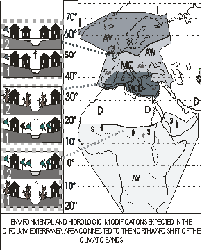
According to the different latitudes many urban areas will be affected, also, by new geoenvironmental problems (figure 2), such as: - anomalous and instantaneous sea-water movements along the urbanised coastal areas; - decrease of the precipitation and of the fresh water availability in the Mediterranean area; - sea water intrusion and subsidence along the coastal alluvial plane; - beach erosion; - catasthrophic flooding in Central Europe; - cathastrophic landslides in the Alpine valleys; - catasthrophic very fast mud flows at the base of slopes characterised by rocky bedroch covered by loose water saturated sediment.
The geoenvironmental security of urban areas must be assured by a modern and advanced knowledge relative to this arguments:
- Geoenvironmental evolution of the anthropised areas: including geoenvironmental knowledge relative the vasta area around the town having a potential influence on the security of the urbanised area (seismicity, volcanism, geomorphological instability of emerged and submerged area, surface hydrology, hydrogeology) and potentially influenced (natural resources, water availability and qualityt) by human activity (polluted water and trash discharge).
- Urban Geology: including the geoenvironmental evolution of the urban area inhabited along a periods of many century where and for this reason representing an important archive containing informations relative to the impact of the geoenvironment on the urban area and viceversa.
- Three dimensional Geology of Urban areas: including the reconstruction of the detailed three-dimensional geologic model of the subsurface, representing the phisical base of the town. It is possible to distinguish the modern urban area into two part: an “emerged” one, representing the surface urbanisation and a “submerged” one, representing the anthropised subsurface. It is evident that in the first century of the third millennium the importance of the submerged town will rapidly increase. In fact, the new urban frontier will be represented by the trhee dimensional plannig of the urban area.
Figure 1 Figure 2