Maremoto nel sud-est asiatico -
Oceano Indiano
26 Dicembre 2004
Sunday 26 December 2004:
at 0100 GMT, an 8.9 magnitude earthquake occurs on the seafloor near
Aceh in northern Indonesia. This earthquake generated a huge tsunami
wave, hitting the coasts of Indonesia, Malaysia, Thailand, Myanmar,
India, Sri Lanka, Maldives and even Somalia.
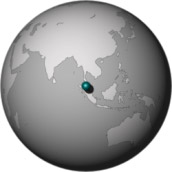
Dove è nel mondo:
Massive
tsunami hits Indian Ocean Coasts
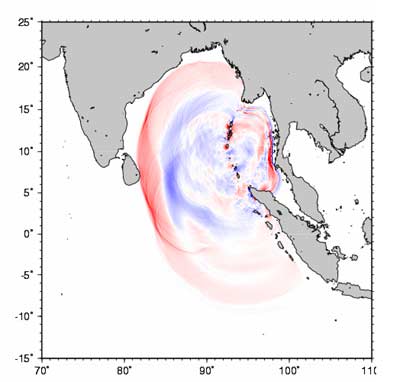
Sunday 26
December 2004.
The image shows how the wave moved towards the surrounding coasts
(Indonesia, Malaysia, Thailand, Myanmar, India, Sri Lanka, Maldives and even
Somalia).
Earthquake Spawns Tsunamis

26 December 2004.
Large earthquakes often cause permanent movement of the Earth’s surface, a result of the motion that occurs deep underground. The tsunamis spawned by the magnitude 9.0 earthquake on December 26, 2004, were the result of motions of the sea floor above the earthquake fault. Seismic measurements and computer models show that the Burma Plate slipped up to 20 meters (66 feet) at the location of the earthquake, 18 kilometers underground. The sea floor above moved less, up to 5 meters (16 feet) vertically and 11 meters (36 feet) horizontally.
The maps above show estimates of how much the Earth moved as a result of the quake. These calculations are the result of a computer simulation that was based on data from a global network of seismic instruments. A black star marks the earthquake epicenter.
On the left is vertical displacement, or uplift. Positive values (red, yellow, and green) show areas that rose during the earthquake, and negative values (blue) show regions that dropped. The maximum rise, along the subduction zone where the Burma Plate is moving over the India Plate, was over 5 meters (16 feet). Along the western edge of Sumatra, the calculations predict the land dropped a maximum of one meter (3.3 feet). This may have moved portions of the coastline permanently below sea level.
On the right is horizontal motion. The greatest motion on the sea floor was 11 meters (36 feet). The coast of Sumatra moved as much as 3 meters (9.8 feet), and the north end of Simeulue Island moved 2 meters (6.6 feet).
Geologists hope to use remote sensing data, combined with on-site GPS measurements, to evaluate the motion predicted by these computer models.
|
Earthquake Spawns Tsunamis
The true-color image above shows an inlet of Little Andaman Island, near the village of Kwate-tu-Kwage. Little Andaman Island is part of India’s Andaman Island chain, situated in the eastern Indian Ocean roughly 965 km (600 miles) south-southeast of Bangladesh. The image shows a swath of destruction (grayish patches) just inland from the beach as buildings and houses were damaged or swept away by surging seawater. The image was acquired on January 2, 2005, by the IKONOS satellite.
On December 26, 2004, a magnitude 9.0 earthquake hit off the west coast of Sumatra, Indonesia, sending shockwaves and tsunamis radiating out from the epicenter. According to news reports, as of January 2, 2005, no relief aid has been sent to the Andaman and Nicobar Islands and little is currently known about the extent of the damage and loss of life there. Although this scene is partly obscured by a thin cloud overhead, many striking details can be seen in the full-resolution copy. A dark crescent of standing water can be seen to the west (left) of the village—possibly the remnants of the tsunami. The image also reveals tsunami destruction to structures along the coast and damage fairly far inland as well. In some cases structures have been ripped off foundations, which is especially noticeable near the inlet.
|

Earthquake Spawns Tsunamis
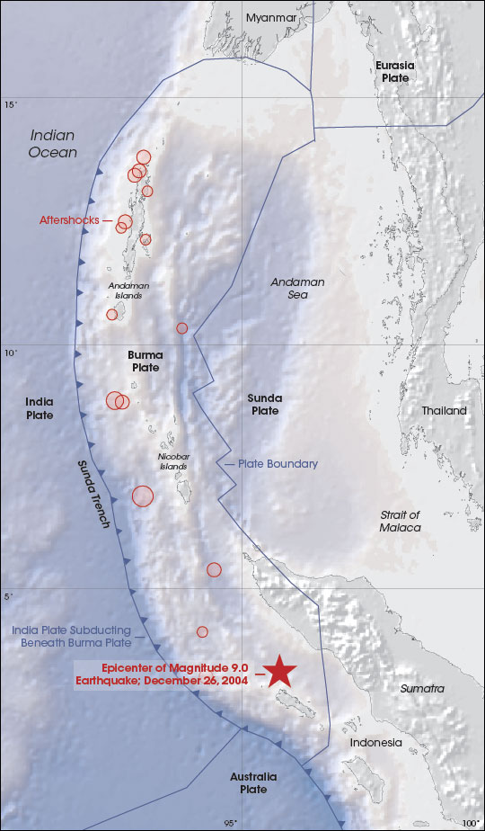
The Earth’s solid surface floats on a layer of softer rock as a collection of interlocking, movable puzzle pieces called tectonic plates. At 7:58 a.m. (local time), on December 26, 2004, beneath the Indian Ocean west of Sumatra, Indonesia, pent-up energy from the compressional forces of one tectonic plate grinding under another found a weak spot in the overlying rock. The rock was thrust upward, and the Earth shook as a 9.0 magnitude earthquake sent its vibrations out into the ocean. Tsunamis spread out in all directions; the massive waves washed over islands and crashed against coastlines in Sri Lanka, Southern India, and even the east coast of Africa. Tens of thousands of people were killed; millions are homeless.
The image above shows how the tectonic puzzle pieces fit together around Indonesia. The epicenter of the recent quake is marked with a red star in the image. It is located just to the east of the Sunda Trench, where the India Plate begins to get subducted beneath (forced under) the Burma Plate. The blue arrows along the plate boundary show the direction of subduction.
As the India Plate slides beneath the Burma Plate, it meets pockets of resistance, which causes compressional forces to build up. Weakened overlying rock gets forced upward. Based on the location of aftershocks (red shaded circles on the image), the United States Geological Survey reports that approximately 1,200 kilometers of the plate boundary probably slipped as a result of the quake. The initial rupture was likely more than 100 kilometers wide, and probably produced an average vertical displacement along the fault plane (the slope along which the two plates meet) of 15 meters.
When the
bottom of the ocean is deformed by this type of “megathrust” quake, the
upward force acts like a fist rising up from underwater. Water rolls down
off the sides of the “fist,” creating massive waves that can travel as fast
as an airplane. The waves can move across the ocean and barely disturb the
surface, but when they reach shallow coastal water, the earthquake’s energy
thrusts them tens of meters into the air. The tsunami created by this
earthquake reached India and Sri Lanka in about four hours. The wave
eventually reached Africa, the Pacific Ocean, Hawaii, and the west coast of
North and South America
Earthquake Spawns Tsunamis
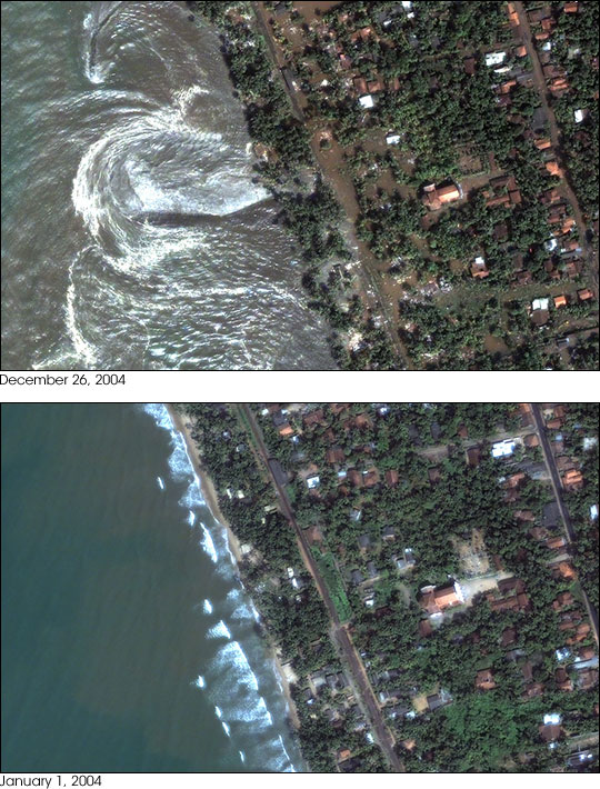
On December 26, 2004, tsunamis swept across the Indian ocean, spawned by a magnitude 9.0 earthquake off the coast of Sumatra. Aside from Indonesia, the island nation of Sri Lanka likely suffered the most casualties, with the death toll reported at 21,715 on December 29th.
DigitalGlobe’s Quickbird satellite captured an image of the devestation around Kalutara, Sri Lanka (top), on December 26, 2004, at 10:20 a.m. local time—about an hour after the first in the series of waves hit. A Quickbird image taken on January 1, 2004 (lower), shows the normal ocean conditions. Water is flowing out of the inundated area and back into the sea, creating turbulence offshore. Some near-shore streets and yards are covered with muddy water. It is possible that the image was acquired in a “trough” between wave crests. Imagery of nearby beaches shows that the edge of the ocean had receded about 150 meters from the shoreline.
Earthquake Spawns Tsunamis
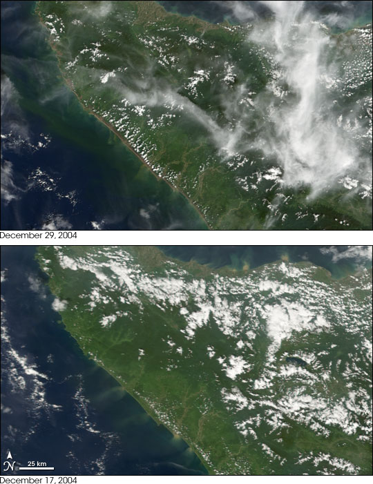
The island of Sumatra suffered from both the rumblings of the submarine earthquake and the tsunamis that were generated on December 26, 2004. Within minutes of the quake, the sea surged ashore, bringing destruction to the coasts of the northern Sumatra. This pair of images from the Moderate Resolution Imaging Spectroradiometer (MODIS) on NASA’s Terra satellite shows the Aceh province of northern Sumatra, Indonesia, on December 17, 2004, before the quake (bottom), and on December 29, 2004 (top), three days after the catastrophe.
Though MODIS was not specifically designed to make the very detailed observations that are usually necessary for mapping coastline changes, the sensor nevertheless observed obvious differences in the Sumatran coastline. On December 17, the green vegetation along the west coast appears to reach all the way to the sea, with only an occasional thin stretch of white that is likely sand. After the earthquake and tsunamis, the entire western coast is lined with a noticeable purplish-brown border.
The brownish border could be deposited sand, or perhaps exposed soil that was stripped bare of vegetation when the large waves rushed ashore and then raced away. On a moderate-resolution image such as this, the affected area may seem small, but each pixel in the full resolution image is 250 by 250 meters. In places the brown strip reaches inland roughly 13 pixels, equal to a distance of 3.25 kilometers, or about 2 miles. On the northern tip of the island (shown in the large image), the incursion is even larger.
Earthquake Spawns Tsunamis
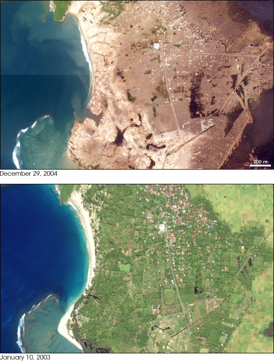
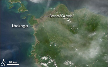
The Indonesian province of Aceh was hit hardest by the earthquake and tsunamis of December 26, 2004. Aceh is located on the northern tip of the island of Sumatra. Early Western media attention was focused on Sri Lanka and Thailand, even though the earthquake epicenter was closer to Aceh, and the largest waves struck the northwestern coast of Sumatra. On Decemebr 29, estimates of the death toll in Indonesia were over 80,000—more than half the global total. The town of Lhoknga, on the west coast of Sumatra near the capital of Aceh, Banda Aceh, was completely destroyed by the tsunami, with the exception of the mosque in the city’s center.
These high-resolution satellite images, acquired by Space Imaging’s Ikonos satellite, show Lhoknga before (lower) and after (top) the earthquake and Tsunami. Almost all the trees, vegetation, and buildings in the area were washed away. Behind the town, low-lying agricultural areas remained covered with water 4 days after the disaster, and sand on the nearby beaches was completely removed. The wave height might have exceeded 15 meters (50 feet) when it struck the shore.
Equivalent devestation extends 225 km southeast along the Sumatran Coast, in a band up to 3 km (1.9 miles) deep. Imagery from the Moderate Resolution Imaging Spectroradiometer (above) shows the affected area as a thin strip of brown along the coast.
Earthquake Spawns Tsunamis
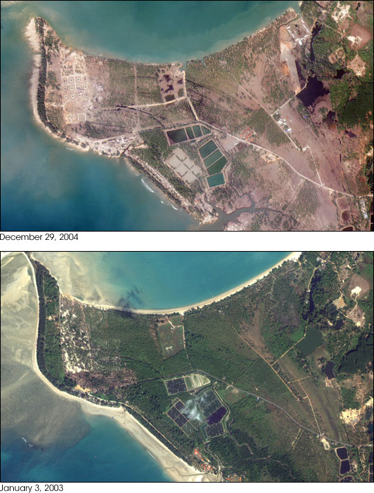
The
beaches of Khao Lak, Thailand were struck by a tsunami 2-3 hours after the
magnitude 9.0 earthquake of December 26, 2004. Although 500 km away from the
epicenter, the waves were 10 meters (33 feet) high. A resort area popular
with Northern European tourists, luxury resorts dotted the coastline (January
3, 2003 image, lower center). Buildings and vegetation were scoured by the
waves, leaving foundations and bare soil. Beach sand was also removed by the
tsunamis. These high-resolution satellite images were acquired by Space
Imaging’s Ikonos satellite.
Earthquake Spawns Tsunamis

Among the first places to be affected by the massive tidal wave that ripped across the Indian Ocean on December 26, 2004, were the Andaman Islands. Located approximately 850 kilometers north of the epicenter of the earthquake that triggered the tsunami, the islands were not only among the first land masses to be swept under the wave, they have also been rattled by a series of aftershocks. Administrated by the Indian government, about 300,000 people live on the remote island chain, including several indigenous tribes. As of January 3, over 6,000 were confirmed dead or missing in the Andaman Islands.
This Moderate Resolution Imaging Spectroradiometer (MODIS) image pair shows a portion of the Andaman Islands on January 3, 2005, left, and January 23, 2003, right. In the most recent image, the beaches along the west side of the islands have been stripped bare, leaving a strip of bright tan land along the coast. The change is most notable on North Sentinel Island, home of the Sentinelese aboriginals, and on Interview Island, where the formerly green coastline has been replaced with an abnormally bright ring of bare sand. North Sentinel is fringed by a coral reef, which appears turquiose in the pre-tsunami image, but which may have been smothered in sand and sediment in the post-tsunami image. The large image reveals additional damage along all the islands of the Andaman chain.