|
Biospeleology of the Piemonte |
 |
Systematic Photographic |
|
Biospeleology of the Piemonte |
|
Systematic Photographic |
 |
|
|
|
 |
 |
 |
|
 |
 |
|
|
|
|
|

The karstic phenomenon in Piemonte
Introduction
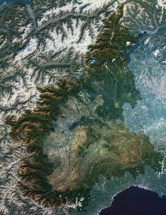
Going along the alpine chain, from the Ligurian Alps to the Monte Rosa (Pink Mons), we are affected by the diversity of forms between the crystalline and metamorphic rock massifs, characterized by indented tops, steep walls and valleys deeply engraved by glaciers and rivers, and the zones where the calcareous rocks emerge, with rather sweet morphologies, tablelands and wide basins without the superficial hydrography.
The karstic phenomenon that interests the karstic lands is in fact characterized by a barrel landscape, different forms of superficial corrosion (furrowed fields, dolines, etc), absence of water circulation in surface that instead exercise their corrosive and erosive action deeply, digging cavities and abysses.
In Piemonte the more important karstic areas are localized in the sector of the Ligurian Alps where the exceptional intensity of the superficial and hypogean phenomena make this zone one of the more interesting areas in the Italian and European karstic panorama. Elsewhere the karstic formations are much more limited: if we exclude some valley, they are generally belts associated to the calcschistes or marbles lenses incorporated in metamorphic grounds. In these zones the epigean karstic phenomena are nearly negligible while the underground karstification is characterized by some cavities with discreet development.
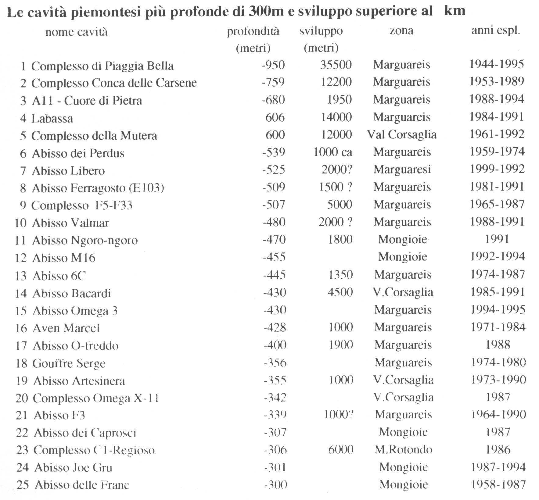
The speleological cadastre groups nearly 2,000 caves on the piemontese territory (identified by a number and the region and province initials), and many of these have very limited interest, but the cavities with particular importance are equally numerous both under the closely speleological point of view and under the scientific, naturalistic, landscaped and even economic aspects.
The main cavities are listed in Table 1; among these the first place is occupied by the system of Piaggia Bella that, with 950 meters of depth and a development of more than 36 km, is considered one of the more important cavities on the italian territory. As we can see, the list appears long and many cavities are also among the greater ones in Italy; their visit, also only for sports purposes, attracts a enough intense flow of speleologists from other Italian regions and from foreign countries.
Under the paleontological, palethnological and archaeological aspects, many cavities have given fossils finds, testimonies of prehistoric human installations or of the use of cavities in ancient historical times. Some caves (like those of Fenera Mons in the Sesia Valley, the "Boira Fusca" in the Orco Valley and the Balm 'Cianto' in Chisone Valley) are became famous in order to have supplied the evidence, until today unique, of the human presence in Piemonte before the Neolithic. But we must consider that the search effected are not many and that the potentiality with regard to this are judged of extreme interest.
Other caves are important for the biospeleology, with rarest endemic troglobite species, as those that we can find in the Camoscere Caves in Pesio Valley, in the Rossana Caves, in the Pugnetto Caves in Lanzo Valley, in order to cite only the more well-known examples.
Some cavities have historical importance, in order to have given shelter to persecuted people during the invasions, the wars of religion, the Resistance.
Not little is the number of caves interesting for the natural beauties that we can observe, and that therefore can be protected or eventually brought out in order to establish tourist flows vital for the local economy. Currently only the Bossea, the Dossi and the Caudano caves, all in the Monregalese, are equipped for the visit of the public, while in others have been facilitated the internal courses in order to allow the approaching without danger or excessive difficulties. Unfortunately in some caves the irresponsibility of the visitors has caused serious damages to the natural and ecological patrimony.
Because of some local situations of deficiency, the use of the groundwater resources of many cavities is one possibility to estimate. The particular stratigraphy and structural situations favor in fact a remarkable groundwater circulation and the presence of numerous systems that feed sources also with much elevated outflows (like those of "La Foce" and "Le Vene" in the High Tanaro Valley, of the Pesio, the Dragonera and the Bandito in the low river basin of the Gesso, of the Maira, etc). Such important points of water supplying are generally little renowned for the territorial operators, but well-known for the speleologists, that, also in collaboration with university agencies, are studying them through direct explorations, tracing tests and specific analyses.
Not only the caves but also the karstic areas of the Piemonte have an interest from the naturalistic point of view, in particolar way for the singularity of the epigean karstic forms and for the abundance of botanical endemites that grow on the limestone substratum.
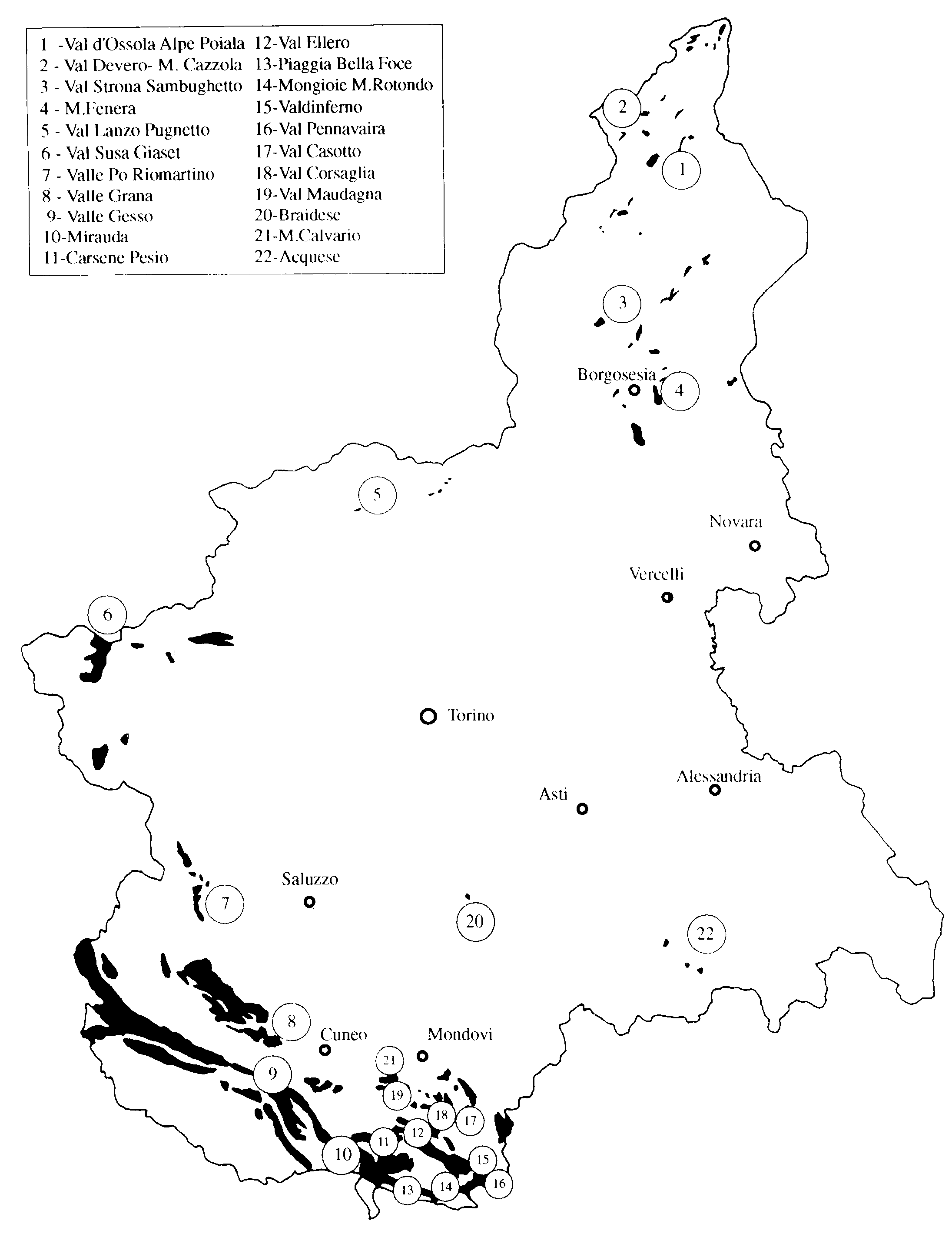
Location of the main calcareous zones (in black) and of the karstic areas
The karstic phenomenon
The karstic areas in Piemonte show a remarkable variety of the superficial forms that, like the geo-lithological factors, are essentially linked to the hypsometry of the zone.
Also the hypogean morphologies show very different aspects; generally we can identify, in the absorption areas, cavities with mostly vertical course with wells and meanders that can reach also remarkable depht, while the rising zones have caves with sub-horizontal course. The circulation of waters is linked to local structural conditions and in particular to the position of the limit of the permeability threshold. There are therefore completely submerged systems, situated under the "talweg" of the rivers; systems with submerged basis or hanging, are characterized by a zone of absorption and transfer active or half-active and a saturated zone with more or less important dimensions; and finally there are systems completely fossil, that testify the lowering of the basal level and the existence of sure prew�rmian deep karstification.
The karstic areas of the Piemonte have been subdivided on the basis of the various geographic, climatic and morphologic characteristics in three main types: high altitude karsts, medium altitude karsts and low elevation karsts.
The high altitude karsts are situated in the higher alpine zones, generally localized near the heads of the main valley systems, they belong to the periglacial morphogenetic systems; the snow in fact covers for more than 6 months a year the ground, and in particular zones remains nearly all the year. The vegetation, very scarce, belongs to the alpine series on limestone and to specialized groupings of the alpine level (little snowy basins, fresh marshy basins, small lakes), is limited to the typical forms of high mountain pasture, of the cliffs, of the detritus stratum and of the moraines.
The superficial morphology is characterized by glacial-karstic basins, wide closed river basins situated above all in the glacial cirques linked both to the glacial erosion and to the karstification. There are also absorbing tablelands, sometimes arranged in series, closed Walloons generally lengthened with parallel direction to the tectonic discontinuity, without superficial hydrology. The more typical macro-formations are the doline with any dimensions (generally prevail those of dissolution), the snowy wells and the swallets. The limestone series are characterized by numerous lithotypes as limestones, dolomitic limestones, arenaceous-marly limestones, dolomites, and shows several shapes according to the lithology of the ground. In the purer and solid limestones, the micro-forms of superficial dissolution which lapiaz, furrows, meanders, little basins are abundant, while the lithotypes more fractured are subject to fast modification due to the sensibility of rocks to the ices, and to one consequent lack of the corrosion forms. The arenaceous and marly impure limestomes with their insoluble residual generate the mature and humiferous grounds with small, usually dry, water furrows where the grass can grow.
As general morphologic outline we can distinguish wide zones of absorption with terraces and karstic-glacial formation, that are followed by steep walls and slopes, at the feet of which are situated the main rising zones. The absorption of waters is very quick and dispersed, the water-drainage in depht follows usually vertical courses, until to reach the local basal level generally situated hundred of meters lower. The geologic-structural situation conditions the entire circulation of waters, organized generally in important systems that drain immense sectors. The springs are therefore characterized by high flows with very variable regimes, because of the high index of karstification.
The more representative and important areas are localized in the south-western zones of the Piemonte.
Along the watersheds between the Varaita-Maira and Stura-Maira-Grana valleys, the karstic landscape is characterized by wide closed river basins, absence of micro-forms of corrosion and swallets, more frequent are the dissolution dolines. In the Ligurian Alps, in the massif of the Marguareis-Mongioie, the karstic phenomena assume an exceptional intensity, the superficial morphology shows wide nude rock areas and mixed karstic-glacial forms. Numerous cavities, decapitate by the glacial exaration or with morainic accumulations, testify the presence of a much developed karstification already in prew�rmian age.
The current forms are constituted by furrowed fiels and richest morphologies of detail on montonate rocks and structural steps of glacial exaration.
The medium altitude karsts are localized in the upper-middle parts of the main hydrographical basins, generally comprised between 1,000 and 2,000 meters of altitude; the morphology is usually characterized by reliefs with enough sweet shapes, that join together with the valley-floor by means of steep slopes. The limestone rocks are generally covered by detritus deriving from the residual effects of the gelifraction and by insoluble detritus. They show a very varied vegetable cover changeable from the beechwoods to the rhododendrons until the typical alpine grasslands, since in them there are vegetation series characteristic both of the mountain level and of the sub-alpine level (in this last one, is very interesting the series of the Mugo pine).
The superficial micro-forms are scarce because of the fast modifications of the rocks due to the intense cryoclastic processes, while abundant are the macro-forms represented by the dolines. Their dimensions are very variable, the walls and the bottom are generally grassy, with limited outcrops of limestone rocks.
The absorption of superficial waters is partially disseminated, partially concentrated in active swallet placed along secondary torrential courses. The position of the main karstic structures, localized cross-sectionally regarding the valley axis, favors the loss under the riverbed of waters coming from contiguous basins. This singular situation generates a conspicuous circulation of groundwaters: testimonies of this fact are underground systems drained by sources characterized by high flows not correlate with the reduced dimensions of the groundwater karstic systems. In the medium altitude karsts there are numerous systems, completely submerged and situated generally under the bed of the main rivers (Rio Mondini, Rio Borello, Vermenagna Torrent, Maudagna Torrent, etc), or systems with important collectors with course mostly sub-horizontal (Mottera Cave, Bossea Cave, etc).
The karstic areas are localized in the Monregalese and more precisely in the Maudagna Valley, in the zone comprised between the pastures of Prato Nevoso and the Balma at the feet of the Mondol� Mons, in Corsaglia Valley, from the Colla dei Termini towards Cima Verzera and the Zottazzo, until the sources of the Mottera and of Borello.
The low altitude karsts interest the areas with prealpine character, in the sections medium and low of the main hydrographical basins, with altimetries comprised between 500 and 1,000 meters of height. The superficial morphology is characterized by a karst generally covered by thick eluvio-colluvial deposits, little permeable, on which grows a thick grassy and wooded vegetation (little oaks -roverella-, chestnut trees, birches, beeches), extremely varied also as number of species and associations, since there are vegetation series of the hilly level of medium-European type, of the hilly level of supramediterranean or submediterranean type and even of the Mediterranean level (as in the Caprauna-Alto zone and in the south-eastern belt of Ormea, that are at the upper limit of such level). The karstic landscape shows hilly reliefs separated by usually dry torrential furrows, and stony and barren tops; the morphologies more typical are constituted by dry valleys and closed depressions, formed frequently by several associated basins, and by series of plateaus, with little marked slope, and strongly absorption, without superficial flowing waters. In the more depressed zones are localized idrovore dolines that drain the temporary waters transported by little torrents. The eluvio-colluvial covers are frequently collapsed and show small funnel-shaped dolines in continuous evolution. The superficial outflow is generally concentrated in swallets and fissures in the torrential riverbeds or in the bottom of the depressions. The waters are collected in small sub-horizontal streams, generally situated along the limits of permeability, characterized by siphoning sections. The karstic systems generally don't reach great dimensions because of the potential limitation of the groundwater flow, but feed numerous sources near them are frequently localized the inhabited centers. These springs have been generally picked up and are used for drinkable use.
The urbanization and the tourist increment that took place in the latter years in the high zones have in many cases facilitated the pollution of the superficial waters and consequently of the below karstic groundwaters.
The more representative karstic areas of the low altitude karst are localized on the Fenera Mons and above all in the Roburentello Valley, in the Monregalese. In this zone there are in fact some of the closed depressions more important of the Piemonte (Bassa di S. Salvatore, Conca delle Turbiglie).
The Marguareis Mons massif
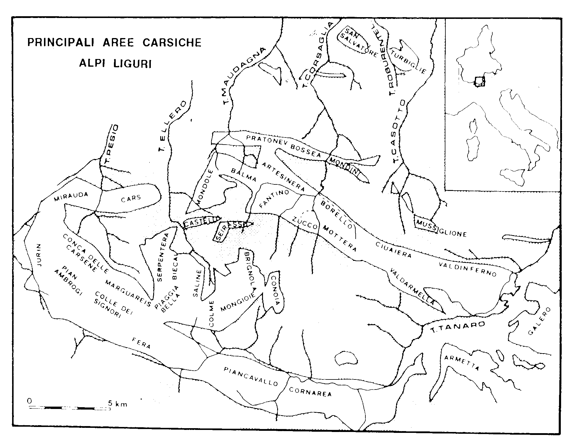
The karstic phenomenon in the southern Piemonte is dominated by the image of the Marguareis but, also in other southern zones, exist phenomena of extreme interest. The massif of the Marguareis, and its continuation towards east (Tanaro Valley) is situated, geographically, in the Ligurian Alps, to the border between the Piemonte and Liguria italian regions and the France; it represents the oriental extremity of the mountainous chain of the Argentera-Mercantour. The zone represents together the Canin and the Apuane Alps one of the main italian karstic areas. The karstic structure extends for more than 60 km�, from the Jurin Mons and the Cima della Fascia in the Vermenagna Valley (over Limone Piemonte) until the Passo delle Saline and to the ridge of the Mongioie Mons in the high Tanaro Valley. The limestone tablelands are situated in this sector at an average altitude of 2,000-2,200 m and are separated from the valley floors, situated around 1,000 m of altitude, by steep calcareous walls, at which basis spring the waters collected in the absorption zones. The explorations carried out in many years by hundred of speleologists have permitted, together to the scientific studies, to have a superficial (epigean), but above all deeply, knowledge of the different karstic systems. all this has allowed to clear which are the key points and above all what are the subterranean courses and where the flows of waters are concentrated, from the surface (absorption zone) until the spring. The massif is subdivided in fact in several absorption zones with relative karstic systems and numerous sources. Some of these have conspicuous outflows (source "La Foce" in the Tanaro Valley, source "Pis del Pesio" in high Pesio Valley, etc) while other emergencies often have modest flows and often we know only partially the absorption zones with the relative caves.
The illustrations and the text have been taken from:
"Atlante delle grotte e delle aree carsiche piemontesi"
("Atlas of the piemontese caves and karstic areas")
AA.VV., 1995
 |
|
|
BIBLIOGRAPHY |
BIBLIOGRAPHY |


|
|
|
 |
|


Some embellishments, Javascript, etc. have been modified
from them situated on the site 
"A SBAFO! All for the WEB gratis and in
Italian... "; the author advise you to visit it.