|
|
PROGRAM
DOWNLOAD - Version 1.6.3
The
program doesn't require to be installed. Just unzip the archive and
run
the main executable file. The help will be available through the
program
menu.
The
program will start with the OpenGL support active and by using a
rendering mode that should work with all the graphic cards,
however, the frame rate may result quite low in some cases. You can try to
choose a better rendering mode for your system by executing the bath (.bat) files.
Note:
- for
Window users (Vista and Seven):
the run-time error '339' may occur. In that case it may be necessary to
unregister and register again the file 'COMCTL32.OCX'. From the folder
where
the program has been unzipped, execute the following commands as
administrator:
In some cases, the problem can be fixed simply by selecting to run
the program in "Windows XP compatibility" (right click on the
executable file and select the option).
If
the
program still doesn't start, right click on the executable file and
select 'Run as administrator'.
- for Linux users: the
program can work under wine
after the necessary fonts are installed (font couri.ttf and pala.ttf). However, OpenGL may not work properly. If you need support, get in touch.
You need or would like a new specific function in the next release? Propose! (satrack@libero.it)
You can now support the development of this program:
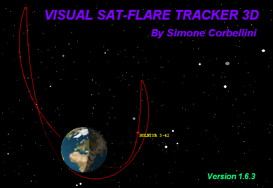 The image represents two orbits of the satellite
Molnya 3-42 plotted with respect to the ground
The image represents two orbits of the satellite
Molnya 3-42 plotted with respect to the ground (ECEF).
Program features (version
1.6.3 - 15 August 2010)
- 3D
/ 2D graphics
- OpenGL
support
- Globe
with
realistic texture and country borders
- Stars
up to magnitude 10 (about 100.000 stars)
- Improved
stars representation
- More
than 1.000 satellites
- ECEF
(Earth Centered Earth Fixed) 3D orbit plotting
- Ground
Track plotting
- Sky
Chart plotting
- Lock View
on Satellite with 3D, skymap, and horizon views
- Real
time capability (video mode, activable with the [V] key)
- Floating
Coordinates Capability (for site searching)
- Transit
search across Sun / Moon
- Ground
Track of Transit Visibility
- Horizon
view
- Visibility
circle plotting
- SGP1,
SDP4/SGP4 Orbit propagation models
- Visual
Flare representation
- Sun/Moon
Light source for flare plotting
- Flare
ground track plotting
- KML
Export for Flare/Transit Tracks (for Google Maps / Google Earth)
- City
along track search (more than 80.000 cities)
- Satellite
surface modelling (mirrors)
- Automatic
orientation of surfaces to flare
- Flare
Predictions
- Graphically
generable IOD reports
- Up
to 10 programmable user views (automatic view switching with
[F] key)
- Load/Save
Workspace capability
- Mouse Wheel support for zooming
on Earth / Sky
- Multi TLE support (what is that?)
By
Simone Corbellini
|
|
|